209.212.195.236 - IP Lookup: Free IP Address Lookup, Postal Code Lookup, IP Location Lookup, IP ASN, Public IP
Country:
 Maldives
Region:
City:
Location:
Time Zone:
Postal Code:
ISP:
ASN:
language:
User-Agent:
Proxy IP:
Blacklist:
IP information under different IP Channel
ip-api
Country
Region
City
ASN
Time Zone
ISP
Blacklist
Proxy
Latitude
Longitude
Postal
Route
db-ip
Country
Region
City
ASN
Time Zone
ISP
Blacklist
Proxy
Latitude
Longitude
Postal
Route
IPinfo
Country
Region
City
ASN
Time Zone
ISP
Blacklist
Proxy
Latitude
Longitude
Postal
Route
IP2Location
209.212.195.236Country
mvRegion
fuvammulah
City
fuvahmulah
Time Zone
ISP
Language
User-Agent
Latitude
Longitude
Postal
ipdata
Country
Region
City
ASN
Time Zone
ISP
Blacklist
Proxy
Latitude
Longitude
Postal
Route
Popular places and events near this IP address

Gnaviyani Atoll
Atoll of the Maldives
Distance: Approx. 1048 meters
Latitude and longitude: -0.3,73.43333333
Gnaviyani Atoll (Dhivehi: ޏ. އަތޮޅު, pronounced [ɳaʋijan̪i at̪oɭu], Nyaviyani) is one of the administrative divisions of the Maldives corresponding to the natural atoll Fuvahmulah. Surfacewise, it is the smallest administrative unit in the Maldives, situated on the Equatorial Channel (Addu - Mulah Kandu) between Huvadhu Atoll and Addu Atoll.
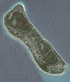
Fuvahmulah
Inhabited island in Gnaviyani Atoll, Maldives
Distance: Approx. 624 meters
Latitude and longitude: -0.29321111,73.4236
Fuvahmulah (Dhivehi: ފުވައްމުލައް) is an island (atoll) in the Maldives. It is under Maldives' administrative division of Gnaviyani (or Nyaviyani) Atoll. The island is the second southernmost administrative atoll, located to the south of Huvadhu Atoll and to the north of Seenu Atoll.

Gen Mosque
Sunni mosque in Fuvahmulah, Maldives
Distance: Approx. 334 meters
Latitude and longitude: -0.29836111,73.42697222
The Gen Miskit (Dhivehi: ގެން މިސްކިތް) is a Sunni Islam mosque, located in the district of Dhadimagu, in Fuvahmulah, on the Gnaviyani Atoll, in the Maldives. Built in c. 1300 and before 1378, it is one of the oldest mosques in the Maldives. The mosque is made of coral stone and was built straight after the conversion to Islam.

Miskiymagu
Administrative division in the Maldives
Distance: Approx. 115 meters
Latitude and longitude: -0.29805556,73.42472222
Miskiymagu is an administrative division of Fuvahmulah, Maldives. The former Dhashokubaa village was merged with Miskimmago.
Funaadu
Administrative division of Fuvahmulah, Maldives
Distance: Approx. 1238 meters
Latitude and longitude: -0.3076,73.4308
Funaadu is an administrative division of Fuvahmulah, Maldives. This is one of the largest wards in Fuvahmulah. The origin of its name lies in some large groves of the tree known locally as "Funa" (Calophyllum inophyllum) that were located on its southern end.

Thoondu
Beach in Fuvahmulah, Maldives
Distance: Approx. 2505 meters
Latitude and longitude: -0.277227,73.417609
Thoondu is a white sandy beach on the north of Fuvahmulah, Maldives. Located within Dhadimagu ward of the island, it is believed to be one of the most well known features of Fuvahmulah. Hundreds of people visit the beach every day, and this figure is much higher during special occasions like Maahefun.
Fuvahmulah Airport
Airport
Distance: Approx. 1516 meters
Latitude and longitude: -0.30944444,73.4325
Fuvahmulah Airport (Dhivehi: ފުވައްމުލަކު އެއަރޕޯޓް, IATA: FVM, ICAO: VRMR) is a domestic airport located on the island of Fuvahmulah (also known as Fuvahmulaku) in Gnaviyani Atoll, Maldives. It was opened in November 2011.
Weather in this IP's area
few clouds
28 Celsius
30 Celsius
28 Celsius
28 Celsius
1009 hPa
67 %
1009 hPa
1009 hPa
10000 meters
5.35 m/s
5.5 m/s
355 degree
14 %