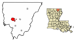
Country:
 USA
USARegion:
City:
Latitude and Longitude:
Time Zone:
Postal Code:
IP information under different IP Channel
ip-api
Country
Region
City
ASN
Time Zone
ISP
Blacklist
Proxy
Latitude
Longitude
Postal
Route
IPinfo
Country
Region
City
ASN
Time Zone
ISP
Blacklist
Proxy
Latitude
Longitude
Postal
Route
MaxMind
Country
Region
City
ASN
Time Zone
ISP
Blacklist
Proxy
Latitude
Longitude
Postal
Route
Luminati
Country
USRegion
la
City
bastrop
ASN
Time Zone
America/Chicago
ISP
UNITI-FIBER
Latitude
Longitude
Postal
db-ip
Country
Region
City
ASN
Time Zone
ISP
Blacklist
Proxy
Latitude
Longitude
Postal
Route
ipdata
Country
Region
City
ASN
Time Zone
ISP
Blacklist
Proxy
Latitude
Longitude
Postal
Route
Popular places and events near this IP address
Bastrop, Louisiana
City in Louisiana, United States
Distance: Approx. 5344 meters
Latitude and longitude: 32.75611111,-91.87222222
Bastrop is a city in Morehouse Parish, Louisiana, United States. It is the parish seat of Morehouse Parish. The population was 9,691 at the 2020 census, down from 11,365 in 2010.
Morehouse Parish School Board
School district in Louisiana, United States
Distance: Approx. 5806 meters
Latitude and longitude: 32.7572,-91.9561
Morehouse Parish School Board is a school district headquartered in an unincorporated area of Morehouse Parish, Louisiana, United States, near the city of Bastrop, the parish seat. The district serves Morehouse Parish.
Christ Episcopal Church (Bastrop, Louisiana)
Historic church in Louisiana, United States
Distance: Approx. 1853 meters
Latitude and longitude: 32.77658,-91.91717
Christ Episcopal Church is a historic Episcopal church building at 206 South Locust Street in Bastrop, Louisiana. The Gothic Revival style building was constructed in 1897 and added to the National Register of Historic Places on July 22, 1982. It has a cruciform plan, and the main entrance is through a square tower set into one corner.

Bastrop High School (Louisiana)
Public high school in Bastrop, , Louisiana, United States
Distance: Approx. 1040 meters
Latitude and longitude: 32.7884,-91.9202
Bastrop High School is a senior high school in Bastrop, Louisiana, United States. It is a part of the Morehouse Parish School Board.
Morehouse Memorial Airport
Airport
Distance: Approx. 4863 meters
Latitude and longitude: 32.75611111,-91.88055556
Morehouse Memorial Airport (ICAO: KBQP, FAA LID: BQP, formerly 2F8) is a public use airport in Morehouse Parish, Louisiana, United States. It is owned by the City of Bastrop and located two nautical miles (4 km) southeast of its central business district. This airport is included in the National Plan of Integrated Airport Systems for 2011–2015, which categorized it as a general aviation facility.

Rose Theatre (Bastrop, Louisiana)
United States historic place
Distance: Approx. 1718 meters
Latitude and longitude: 32.77707,-91.91419
The Rose Theatre in downtown Bastrop in Morehouse Parish, Louisiana was built in 1927. It was listed on the National Register of Historic Places on September 8, 1987. It is a two-story Arts and Crafts-style brick building.

Morehouse Parish Courthouse
United States historic place
Distance: Approx. 1635 meters
Latitude and longitude: 32.77778,-91.91387
The Morehouse Parish Courthouse, at 100 East Madison Avenue in Bastrop in Morehouse Parish, Louisiana, is a Beaux Arts-style building which was built in 1914. It was listed on the National Register of Historic Places on December 27, 2002. It is a three-story monumental building on a half-story-high basement, with beige brick veneer walls and a four-stage dome.
Bastrop High School Building (Bastrop, Louisiana)
United States historic place
Distance: Approx. 2287 meters
Latitude and longitude: 32.77181,-91.91386
Bastrop High School, at 715 S. Washington St. in Bastrop, Morehouse Parish, Louisiana in north Louisiana, was built in two stages in 1927 and 1930. It was listed on the National Register of Historic Places on December 20, 2002.
Snyder Memorial Museum and Creative Arts Center
United States historic place
Distance: Approx. 1926 meters
Latitude and longitude: 32.77959,-91.89579
The Snyder Memorial Museum and Creative Arts Center, formerly the Snyder House, at 1620 East Madison Avenue in Bastrop in Morehouse Parish in northern Louisiana, was built in 1929. It was listed on the National Register of Historic Places on October 18, 1996. The listing included two contributing buildings.
Weather in this IP's area
clear sky
21 Celsius
20 Celsius
21 Celsius
21 Celsius
1027 hPa
30 %
1027 hPa
1022 hPa
10000 meters
0.45 m/s
2.68 m/s
98 degree
07:14:13
18:30:49