209.208.245.70 - IP Lookup: Free IP Address Lookup, Postal Code Lookup, IP Location Lookup, IP ASN, Public IP
Country:
Region:
City:
Location:
Time Zone:
Postal Code:
IP information under different IP Channel
ip-api
Country
Region
City
ASN
Time Zone
ISP
Blacklist
Proxy
Latitude
Longitude
Postal
Route
Luminati
Country
Region
ga
City
atlanta
ASN
Time Zone
America/New_York
ISP
QTS-SUW1-ATL1
Latitude
Longitude
Postal
IPinfo
Country
Region
City
ASN
Time Zone
ISP
Blacklist
Proxy
Latitude
Longitude
Postal
Route
IP2Location
209.208.245.70Country
Region
district of columbia
City
washington
Time Zone
America/New_York
ISP
Language
User-Agent
Latitude
Longitude
Postal
db-ip
Country
Region
City
ASN
Time Zone
ISP
Blacklist
Proxy
Latitude
Longitude
Postal
Route
ipdata
Country
Region
City
ASN
Time Zone
ISP
Blacklist
Proxy
Latitude
Longitude
Postal
Route
Popular places and events near this IP address

M Street (Washington, D.C.)
Four streets of the same name in Washington, D.C.
Distance: Approx. 124 meters
Latitude and longitude: 38.9056494,-77.0414223
The name "M Street" refers to two major roads in the United States capital of Washington, D.C. Because of the Cartesian coordinate system used to name streets in Washington, the name "M Street" can be used to refer to any east–west street located twelve blocks north or south of the dome of the United States Capitol (not thirteen blocks, as there is no J Street).

Jefferson Place Gallery
Distance: Approx. 36 meters
Latitude and longitude: 38.907016,-77.042002
The Jefferson Place Gallery was an art gallery in Washington, D.C., founded in 1957 and closed in 1974. It had been located at 1216 Connecticut Street, NW in Washington, D.C.. The gallery was associated with the Washington Color School artists.

General Federation of Women's Clubs Headquarters
Historic house in Washington, D.C., United States
Distance: Approx. 143 meters
Latitude and longitude: 38.90694444,-77.04027778
The General Federation of Women's Clubs (GFWC) Headquarters, also known as the Miles Mansion, is located in Washington, D.C. Built as a private residence in 1875, it has served as the headquarters of GFWC since 1922. It was declared a National Historic Landmark in 1991 for its association with the federation, which serves as an umbrella organization for women's clubs, dating to the mid-19th century. Tours of the headquarters, available by appointment, provide information about the activities of the GFWC and several historic rooms, including the 1734 entryway, the Julia Ward Howe Drawing Room, the dining room, music room and the GFWC International President's office.

Elliott Coues House
Historic house in Washington, D.C., United States
Distance: Approx. 167 meters
Latitude and longitude: 38.90694444,-77.04
The Elliott Coues House is a historic house at 1726 N Street NW, in the Dupont Circle neighborhood of Washington, D.C. Built about 1880, it was the home of 19th-century historian and ornithologist Elliott Coues (1842–99) from about 1887 until his death. Coues helped found the American Ornithologists' Union in 1883 and edited about 15 volumes of journals, memoirs, and diaries by famous Western explorers and fur traders. The house was declared a National Historic Landmark in 1975.

Qorvis
American company
Distance: Approx. 115 meters
Latitude and longitude: 38.90601111,-77.04091389
Qorvis is an international Washington, D.C.–based public relations, advertising, media relations and crisis communications firm. It was acquired by the Publicis Groupe in January 2014, and became Qorvis/MSLGroup.On December 31, 2022, Qorvis was sold by Publicis to a group led by long-time Qorvis executive Matt J. Lauer. Qorvis provides public relations (PR) representation on behalf of a range of public companies, financial services firms, sovereign nations, and wealthy individuals.

Henry Wadsworth Longfellow Memorial
Statue in Washington, D.C., U.S.
Distance: Approx. 99 meters
Latitude and longitude: 38.90583333,-77.04166667
Henry Wadsworth Longfellow is a bronze statue, by William Couper, and Thomas Ball. The statue depicts American poet Henry Wadsworth Longfellow. It is located at the intersection of M Street and Connecticut Avenue, N.W. Washington, D.C., and was dedicated on May 7, 1909.
Statue of John Witherspoon
Statue by William Couper in Washington, D.C., U.S.
Distance: Approx. 53 meters
Latitude and longitude: 38.90716667,-77.04177778
Doctor John Witherspoon is a bronze sculpture and granite pedestal which depicts John Witherspoon, a Presbyterian minister, member of Congress, and signer of the Declaration of Independence. Born in Scotland, Witherspoon immigrated to the U.S. in the 1760s and later became president of the College of New Jersey (now known as Princeton University). He strongly supported the Thirteen Colonies in their fight to obtain freedom from the United Kingdom of Great Britain and Ireland.
Embassy of Honduras, Washington, D.C.
Diplomatic mission
Distance: Approx. 168 meters
Latitude and longitude: 38.90661111,-77.04383333
The Embassy of Honduras in Washington, D.C. is the diplomatic mission of Honduras to the United States. It is located at 1220 19th Street, Northwest, Washington, D.C. Separately, Honduras has a consulate-general located at 1990 M St NW, Washington, D.C. The embassy also operates consulates-general in Atlanta, Boston, Charlotte, Chicago, Dallas, Houston, Los Angeles, McAllen, Miami, New Orleans, New York City, San Francisco and Seattle. The ambassador is Luis Fernando Suazo Barahona.
National Association of Clean Water Agencies
Distance: Approx. 65 meters
Latitude and longitude: 38.906245,-77.042378
National Association of Clean Water Agencies (NACWA) represents the interests of publicly owned wastewater treatment facilities, collection systems, and stormwater management agencies before the United States Congress, several Federal agencies, and in the courts. National Association of Clean Water Agencies advocates for federal funding for clean water agencies and for responsible national policies that advance clean water and a healthy environment.
List of ambassadors of São Tomé and Príncipe to the United States
Distance: Approx. 97 meters
Latitude and longitude: 38.906292,-77.040908
The São Toméan] ambassador in Washington, D.C. is the official representative of the Government in São Tomé to the Government of the United States.

Demonet Building
Historic building in Washington, D.C., U.S.
Distance: Approx. 156 meters
Latitude and longitude: 38.9054212,-77.0411755
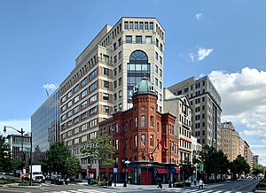
The Demonet Building is composed of a historic townhouse and adjoining office building on the southeast corner of Connecticut Avenue and M Street N.W. in Washington, D.C. Constructed in 1880, the townhouse is the last Victorian residence on Connecticut Avenue between Dupont Circle and Farragut Square that has not been significantly altered. It features an octagonal tower topped by a dome with cartouche windows. Following a multi-year legal battle to demolish the townhouse, which had been added to the District of Columbia Inventory of Historic Sites in 1979, the Demonet Building and adjoining lot were sold for what was then a record price for downtown real estate.
H2 USA
Alliance promoting US hydrogen technology
Distance: Approx. 86 meters
Latitude and longitude: 38.90628,-77.04106
H2 USA is a hybrid organization governed by a partnership affiliated with the United States private sector economy and the public sector services. The alliance is supportive of a hydrogen economy and hydrogen technologies with a representation by more than thirty cooperatives considering associations, automakers, energy companies, fuel cell suppliers, materials and component manufacturers, national laboratories, non-governmental organizations, and the United States Department of Energy.
Weather in this IP's area
scattered clouds
1 Celsius
-3 Celsius
-1 Celsius
2 Celsius
1034 hPa
51 %
1034 hPa
1031 hPa
10000 meters
4.12 m/s
140 degree
40 %
