Country:
 Slovakia
Region:
City:
Latitude and Longitude:
Time Zone:
Postal Code:
IP information under different IP Channel
ip-api
Country
Region
City
ASN
Time Zone
ISP
Blacklist
Proxy
Latitude
Longitude
Postal
Route
IPinfo
Country
Region
City
ASN
Time Zone
ISP
Blacklist
Proxy
Latitude
Longitude
Postal
Route
MaxMind
Country
Region
City
ASN
Time Zone
ISP
Blacklist
Proxy
Latitude
Longitude
Postal
Route
Luminati
Country
SKRegion
bl
City
bratislava
ASN
Time Zone
Europe/Bratislava
ISP
Cato Networks Ltd
Latitude
Longitude
Postal
db-ip
Country
Region
City
ASN
Time Zone
ISP
Blacklist
Proxy
Latitude
Longitude
Postal
Route
ipdata
Country
Region
City
ASN
Time Zone
ISP
Blacklist
Proxy
Latitude
Longitude
Postal
Route
Popular places and events near this IP address

Battle of Blumenau
Distance: Approx. 1558 meters
Latitude and longitude: 48.192398,17.053855
The Battle of Blumenau or Battle of Lamač was the last battle fought in the Austro-Prussian War, on 22 July 1866 (on the day of the conclusion of peace), with the Austrians defending against the Prussian army.

Sitina Tunnel
Tunnel in Bratislava
Distance: Approx. 3565 meters
Latitude and longitude: 48.16288056,17.0749
The Sitina Tunnel (alternatives Sitiny Tunnel or Františka Tunnel) is a motorway tunnel in Bratislava, Slovakia on the D2 motorway at the "Lamačská cesta - Staré grunty" section. The tunnel goes under the Little Carpathians forest. It is the first two-tube tunnel in Slovakia and by its opening, the entire D2 motorway in Slovakia was completed.

Devínska Kobyla
Distance: Approx. 3225 meters
Latitude and longitude: 48.19055556,16.99583333
Devínska Kobyla (Slovak pronunciation: [ˈɟeʋiːnska ˈkɔbila]; Hungarian: Dévényi-tető; German: Thebener Kogel) is the highest peak in the Devín Carpathians, part of the Little Carpathians mountain range, and the highest point of Bratislava, the capital of Slovakia. It is located between the boroughs of Devínska Nová Ves, Devín and Dúbravka, close to the border with Austria. Its peak elevation is 514 m (1686.3 ft) AMSL and its treeless summit contains an abandoned military missile base (Slovak: Rádiotechnická hláska protivzdušnej obrany štátu) that is officially inaccessible to the public.

Church of the Holy Spirit, Bratislava
Church building in Bratislava, Slovakia
Distance: Approx. 188 meters
Latitude and longitude: 48.18488889,17.03703889
Church of the Holy Spirit is a church in Bratislava, Slovakia. The cornerstone was sanctified by Pope John Paul II. It is an atypical building with an unusual roof, 30m high. It has a circular shape and consists of church and pastoral sections.
Bratislava Železná studienka railway station
Railway stop in Bratislava, Slovakia
Distance: Approx. 2770 meters
Latitude and longitude: 48.17444444,17.07277778
Bratislava Železná studienka railway station (Hungarian: Pozsony-Vaskutacska vasútállomás, Slovak: Železničná zastávka Bratislava-Železná studienka; Železničná zastávka Bratislava-Železná studnička; Železničná stanica Bratislava-Železná studienka; Železničná stanica Bratislava-Železná studnička, Czech: Železniční zastávka Bratislava-Železní studénka; Železniční zastávka Bratislava-Železní studnička; Železniční stanice Bratislava-Železní studénka; Železniční stanice Bratislava-Železní studnička) is a small railway station (technically a train halt) inside the Bratislava Forest Park recreational zone in northern Bratislava, Slovakia. The station is still in use, although few trains stop here nowadays. It has two platforms, the one by rail number one being 149 metres (489 ft) long and 3 metres (10 ft) wide and the one by rail number two being 160 metres (525 ft) long and 3.6 metres (12 ft) wide.

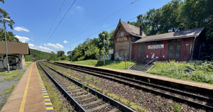
Bratislava Lamač railway station
Railway station in Bratislava, Slovakia
Distance: Approx. 844 meters
Latitude and longitude: 48.18583333,17.04861111
Bratislava Lamač railway station (Hungarian: Pozsony-Lamacs vasútállomás, Slovak: Železničná stanica Bratislava-Lamač, Czech: Železniční stanice Bratislava-Lamač) is a small railway station (technically a train halt) inside the Lamač borough of Bratislava, Slovakia. Until 1947 the station was called "Lamač". The railway station is administered under Bratislava main railway station, with the station master (Slovak: prednosta) residing there as well.

Evangelical Church, Dúbravka
Distance: Approx. 808 meters
Latitude and longitude: 48.17833333,17.04583333
The Evangelical church in Dúbravka, a suburb of Bratislava, is the second-youngest religious building in this part of Bratislava. Originally built as a ceremonial hall in the 1980s, regular evangelical worship services began in 1995. In 2003, the building became the property of the Slovak Evangelical Church.

Stadium ŠKP Inter Dúbravka
Distance: Approx. 1209 meters
Latitude and longitude: 48.17583333,17.04972222
Stadium ŠKP Inter Dúbravka (Slovak: Štadión ŠKP Inter Dúbravka) is a football stadium in Dúbravka, Slovakia and is the home stadium of the FK Inter Bratislava and FK ŠKP Inter Dúbravka Bratislava. FK Inter Bratislava started playing at the stadium in Summer 2014. Stadium capacity is 5000, including 250 VIP seats.
British International School Bratislava
Private school, international school in Dúbravka, Bratislava, Slovakia
Distance: Approx. 513 meters
Latitude and longitude: 48.187255,17.034355
The British International School Bratislava (BISB), established in 1997, is one of the oldest international schools in Slovakia. The school educates over 770 students between the ages of 3 and 18 years from over 45 countries. BISB educates children at pre-school, primary and secondary level and it is located in Dubravka.
Institute of Inorganic Chemistry Slovak Academy of Sciences
Distance: Approx. 2877 meters
Latitude and longitude: 48.1688741,17.0700497
Institute of Inorganic Chemistry Slovak Academy of Sciences (IIC SAS; Ústav anorganickej chémie Slovenskej akadémie vied) belongs to Scientific Section 2, Biological and Chemical Sciences of Slovak Academy of Sciences.
Lamač Gate
Distance: Approx. 2178 meters
Latitude and longitude: 48.1749,17.0644
Lamač Gate (Slovak: Lamačská brána) is a tectonic erosion subsidence in Bratislava, the capital of Slovakia. It is one out of four geomorphological areas of the Devín Carpathians, part of the Little Carpathians mountain range, separating Devín Carpathians from the central massif of Little Carpathians. The city borough of Lamač and parts of Dúbravka lie geographically within the Lamač Gate.

Bratislava Foothills
Mountain range in Bratislava
Distance: Approx. 3371 meters
Latitude and longitude: 48.2,17
Bratislava Foothills (Slovak: Bratislavské predhorie) is a small mountain range located in Bratislava, the capital of Slovakia. It is part of the Devín Carpathians mountain range, located in the northwest of the city. Mean altitude of the mountain range is 250 metres above sea level.
Weather in this IP's area
scattered clouds
12 Celsius
11 Celsius
11 Celsius
13 Celsius
1021 hPa
64 %
1021 hPa
994 hPa
10000 meters
5.7 m/s
13.6 m/s
131 degree
33 %
07:15:57
17:57:36