Country:
 Luxembourg
Region:
City:
Latitude and Longitude:
Time Zone:
Postal Code:
IP information under different IP Channel
ip-api
Country
Region
City
ASN
Time Zone
ISP
Blacklist
Proxy
Latitude
Longitude
Postal
Route
IPinfo
Country
Region
City
ASN
Time Zone
ISP
Blacklist
Proxy
Latitude
Longitude
Postal
Route
MaxMind
Country
Region
City
ASN
Time Zone
ISP
Blacklist
Proxy
Latitude
Longitude
Postal
Route
Luminati
Country
LUASN
Time Zone
Europe/Luxembourg
ISP
Cato Networks Ltd
Latitude
Longitude
Postal
db-ip
Country
Region
City
ASN
Time Zone
ISP
Blacklist
Proxy
Latitude
Longitude
Postal
Route
ipdata
Country
Region
City
ASN
Time Zone
ISP
Blacklist
Proxy
Latitude
Longitude
Postal
Route
Popular places and events near this IP address

Luxembourg City
Capital and largest city of Luxembourg
Distance: Approx. 7 meters
Latitude and longitude: 49.61166667,6.13194444
Luxembourg (Luxembourgish: Lëtzebuerg; French: Luxembourg; German: Luxemburg), also known as Luxembourg City (Luxembourgish: Stad Lëtzebuerg or d'Stad; French: Ville de Luxembourg; German: Stadt Luxemburg or Luxemburg-Stadt), is the capital city of Luxembourg and the country's most populous commune. Standing at the confluence of the Alzette and Pétrusse rivers in southern Luxembourg, the city lies at the heart of Western Europe, situated 213 km (132 mi) by road from Brussels and 209 km (130 mi) from Cologne. The city contains Luxembourg Castle, established by the Franks in the Early Middle Ages, around which a settlement developed.
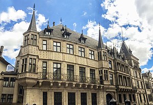
Grand Ducal Palace, Luxembourg
Official residence of the Grand Duke of Luxembourg
Distance: Approx. 103 meters
Latitude and longitude: 49.61088889,6.13283333
The Grand Ducal Palace (Luxembourgish: Groussherzogleche Palais, French: Palais grand-ducal, German: Großherzogliches Palais) is a palace in Luxembourg City, in southern Luxembourg. It is the official residence of the grand duke of Luxembourg, and where he performs most of his duties as head of state of the grand duchy, though his principal residence is Berg Castle, in Colmar-Berg.
Krautmaart
Distance: Approx. 123 meters
Latitude and longitude: 49.61055556,6.1325
Krautmaart (Luxembourgish) or rue du Marché aux Herbes (French), is an irregularly-shaped street in Luxembourg City, in southern Luxembourg. The street, whose name translates into English as Herb Market street, is situated in Ville Haute, the historic heart of the city. It lies to the east of Place Guillaume II, across the rue du Fossé.

National Museum of History and Art
Art museum in Luxembourg City, Luxembourg
Distance: Approx. 90 meters
Latitude and longitude: 49.61194444,6.13305556
The National Museum of History and Art (Luxembourgish: Nationalmusée fir Geschicht a Konscht, French: Musée national d'histoire et d'art, German: Nationalmuseum für Geschichte und Kunst), abbreviated to MNHA, is a museum located in Luxembourg City, in southern Luxembourg. It is dedicated to displaying artworks and artefacts from all epochs of Luxembourg history. The museum is situated in Fishmarket, the historic heart of the city, in the Ville Haute quarter.

Place Guillaume II
Square in Luxembourg, Luxembourg
Distance: Approx. 147 meters
Latitude and longitude: 49.61083333,6.13027778
Place Guillaume II is a town square in Luxembourg City, in southern Luxembourg. The square is in the heart of Luxembourg's historic Ville Haute quarter. It is colloquially known as Knuedler, from the Luxembourgish language's word for "knot", referring to the knot in the belt worn by Franciscan friars.
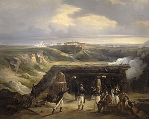
Siege of Luxembourg (1794–1795)
1794–1795 siege during the War of the First Coalition
Distance: Approx. 102 meters
Latitude and longitude: 49.611,6.133
The siege of Luxembourg was a siege by France of the Habsburg-held Fortress of Luxembourg that lasted from 1794 until 7 June 1795, during the French Revolutionary Wars. Although the French army failed to breach the walls of the city, which were renowned as amongst the best in the world, the fortress was forced to surrender after more than seven months. Luxembourg's long defence led Lazare Carnot to call Luxembourg "the best [fortress] in the world, except Gibraltar", giving rise to the city's nickname 'the Gibraltar of the North'.

Fishmarket
Neighborhood of Luxembourg City
Distance: Approx. 164 meters
Latitude and longitude: 49.611,6.134
Fishmarket (Luxembourgish: Fëschmaart, French: Marché-aux-Poissons, German: Fischmarkt), also spelt Fish Market, is a street in Luxembourg City, in southern Luxembourg, that shares its name with the neighbourhood directly surrounding it. It lies in the eastern part of the Ville Haute quarter. Fishmarket was historically the centre of the city.

Hôtel de la Chambre
Legislative building in Luxembourg City, Luxembourg
Distance: Approx. 136 meters
Latitude and longitude: 49.610625,6.13307222
The Hôtel de la Chambre des Députés (English: Hall of the Chamber of Deputies) is the meeting place of the Luxembourgish national legislature, the Chamber of Deputies, in Luxembourg City, in southern Luxembourg. It is located on Krautmaart, an irregularly shaped street in the historic heart of the city, in Ville Haute quarter. Next to the Chamber is the Grand Ducal Palace, the official residence of the Grand Duke of Luxembourg.

Cercle Municipal
Distance: Approx. 161 meters
Latitude and longitude: 49.61138889,6.12972222
The Cercle Municipal or Cercle Cité is a building in Luxembourg City, in southern Luxembourg. It is located at the eastern end of the Place d'Armes, in the historic central Ville Haute quarter of the city.
Timeline of Luxembourg City
Distance: Approx. 139 meters
Latitude and longitude: 49.611667,6.13
The following is a timeline of the history of Luxembourg City, Luxembourg.

ARBED building
Former headquarters of ArcelorMittal
Distance: Approx. 102 meters
Latitude and longitude: 49.6125,6.13166667
The ARBED building is the generally used name for the headquarters of ArcelorMittal and one of its predecessors, the ARBED steel manufacturing company, which was completed in 1922 on the Avenue de la Liberté, opposite the Rose Garden in Luxembourg City. The architect was the Frenchman René Théry, and construction was overseen by Sosthène Weis.

Old City of Luxembourg
UNESCO World Heritage Site
Distance: Approx. 154 meters
Latitude and longitude: 49.611,6.13
The Old City of Luxembourg (officially City of Luxembourg: its Old Quarters and Fortifications) is located mainly in Ville Haute (Uewerstad) in Luxembourg City, Grand Duchy of Luxembourg. The site was added to the UNESCO World Heritage list in 1994. The origin of the city was a fort built in the 10th century and had to be demolished in most parts in the 19th century (the casemates, the bastion and some walls still exist partly).
Weather in this IP's area
light rain
17 Celsius
17 Celsius
16 Celsius
17 Celsius
1012 hPa
92 %
1012 hPa
978 hPa
10000 meters
4.63 m/s
240 degree
20 %
07:01:53
20:04:36