209.20.152.191 - IP Lookup: Free IP Address Lookup, Postal Code Lookup, IP Location Lookup, IP ASN, Public IP
Country:
Region:
City:
Location:
Time Zone:
Postal Code:
IP information under different IP Channel
ip-api
Country
Region
City
ASN
Time Zone
ISP
Blacklist
Proxy
Latitude
Longitude
Postal
Route
Luminati
Country
ASN
Time Zone
America/Chicago
ISP
CHIRISA-TECHNOLOGY-PARKS-01
Latitude
Longitude
Postal
IPinfo
Country
Region
City
ASN
Time Zone
ISP
Blacklist
Proxy
Latitude
Longitude
Postal
Route
IP2Location
209.20.152.191Country
Region
virginia
City
chester
Time Zone
America/New_York
ISP
Language
User-Agent
Latitude
Longitude
Postal
db-ip
Country
Region
City
ASN
Time Zone
ISP
Blacklist
Proxy
Latitude
Longitude
Postal
Route
ipdata
Country
Region
City
ASN
Time Zone
ISP
Blacklist
Proxy
Latitude
Longitude
Postal
Route
Popular places and events near this IP address
CSS Hampton
Distance: Approx. 4061 meters
Latitude and longitude: 37.377,-77.357
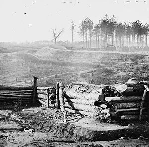
CSS Hampton was a wooden gunboat of the Confederate States Navy, one of the few Hampton class gunboats to be built. Hampton was built at Norfolk Naval Shipyard in 1862 and based there until May 1862, when the yard was abandoned and the fleet moved up the James River. With Lieutenant John Herndon Maury, CSN, in command, Hampton participated in significant river actions including the battle at Dutch Gap on August 13, 1864; operations against Fort Harrison on September 29-October 1; and the engagement at Chaffin's Bluff on October 22.

Bermuda Hundred campaign
Part of the American Civil War in Virginia
Distance: Approx. 944 meters
Latitude and longitude: 37.3432,-77.3197
The Bermuda Hundred campaign was a series of battles fought at the town of Bermuda Hundred, outside Richmond, Virginia, during May 1864 in the American Civil War. Union Maj. Gen.

Varina-Enon Bridge
Bridge in Chesterfield and Henrico counties, Virginia
Distance: Approx. 3780 meters
Latitude and longitude: 37.37974,-77.346368
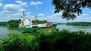
Varina-Enon Bridge is a cable-stayed bridge which carries Interstate 295 across the James River near Dutch Gap between Henrico County near Richmond and Chesterfield County near Hopewell, Virginia. It was opened to traffic in July 1990. The Varina-Enon Bridge has six lanes (three lanes each way) with full right and left shoulders, with 150 feet (46 m) of vertical navigational clearance and 630 feet (190 m) of horizontal navigational clearance.
Henricus
Archaeological site in Virginia, United States
Distance: Approx. 4139 meters
Latitude and longitude: 37.374,-77.362
The "Citie of Henricus"—also known as Henricopolis, Henrico Town or Henrico—was a settlement in Virginia founded by Sir Thomas Dale in 1611 as an alternative to the swampy and dangerous area around the original English settlement at Jamestown, Virginia. Named for Henry, Prince of Wales (1594–1612), the eldest son of King James I, Henricus is located on a former curl of the James River about 12 miles southeast of the modern city of Richmond, Virginia or 15 miles from the fall line of the James River. Today, the settlement is interpreted via Henricus Historical Park, a living history museum.

Dutch Gap Canal
Distance: Approx. 4180 meters
Latitude and longitude: 37.37723,-77.358698
Dutch Gap Canal is located on the James River in Chesterfield County, Virginia just north of the lost 17th-century town of Henricus. The canal's construction was initiated by Union forces during the American Civil War to bypass a meander loop of the river around a peninsula known as Farrar's Island that was controlled by Confederate artillery. The canal was completed after the war and is now the main channel of the James River in this area.

Varina, Virginia
Former unincorporated community and current magisterial district in Virginia, United States
Distance: Approx. 3696 meters
Latitude and longitude: 37.38194444,-77.33611111
Varina ( və-RY-nə) is a former unincorporated community and current magisterial district in the easternmost portion of Henrico County, Virginia, United States.

Varina Farms
Historic house in Virginia, United States
Distance: Approx. 3660 meters
Latitude and longitude: 37.38166667,-77.33583333
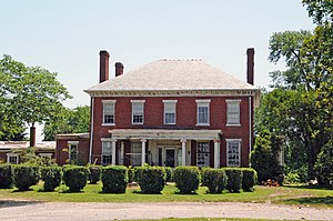
Varina Farms, also known as Varina Plantation or Varina Farms Plantation or Varina on the James, is a plantation established in the 17th century on the James River about 10 miles (16 km) south of Richmond, Virginia. An 820-acre (330 ha) property was listed on the National Register of Historic Places in 1977 as "Varina Plantation". At that time it included two contributing buildings and one other contributing site.
Enon, Virginia
Census-designated place in Virginia, US
Distance: Approx. 2573 meters
Latitude and longitude: 37.32722222,-77.31944444
Enon is a census-designated place (CDP) located in the eastern point of Chesterfield County, Virginia, United States, just east of Chester. The population as of the 2020 census was 4,075.

City of Henrico (Virginia Company)
Early colonial incorporation in Virginia
Distance: Approx. 3660 meters
Latitude and longitude: 37.38166667,-77.33583333
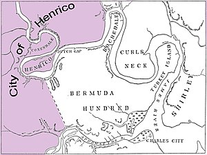
The City of Henrico (also known as Henrico) is one of the oldest counties in the Colony of Virginia. It was one of four incorporations established in the colony by its proprietor, the Virginia Company. The City of Henrico, which included the settlement of Henricus, was the furthest incorporation upstream on the James River.

Bermuda Hundred, Virginia
Unincorporated community in Virginia, United States
Distance: Approx. 4450 meters
Latitude and longitude: 37.33938889,-77.27808333
Bermuda Hundred was the first administrative division in the English colony of Virginia. It was founded by Sir Thomas Dale in 1613, six years after Jamestown. At the southwestern edge of the confluence of the Appomattox and James Rivers opposite City Point, annexed to Hopewell, Virginia in 1923, Bermuda Hundred was a port town for many years.
Dutch Gap Canal Lights
Lighthouses in Virginia, United States
Distance: Approx. 4178 meters
Latitude and longitude: 37.37658333,-77.35952778
The Dutch Gap Canal Lights were built to mark the ends of Dutch Gap Canal, now called Dutch Gap Cutoff, which is a 3⁄4 nautical mile (1.4 km; 0.86 mi) cut across the base of an oxbow in the James River between Hopewell and Richmond, Virginia. They were on Farrar's Island, on the south side of the river. The first two structures were small wood frame towers similar in design to the Jordan Point Light, together with a keeper's house, which were built in 1875.
Dominion Energy Charity Classic
American professional golf tournament
Distance: Approx. 3436 meters
Latitude and longitude: 37.3413,-77.3641
The Dominion Energy Charity Classic is a professional golf tournament in Virginia on the PGA Tour Champions, played at Country Club of Virginia in Henrico, Virginia. The inaugural edition was in November 2016. The event features a 72-player field competing for a $2.2 million purse, and is a no-cut 54-hole event.
Weather in this IP's area
moderate rain
10 Celsius
10 Celsius
9 Celsius
12 Celsius
1024 hPa
95 %
1024 hPa
1021 hPa
10000 meters
100 %
