Country:
 USA
USARegion:
City:
Latitude and Longitude:
Time Zone:
Postal Code:
IP information under different IP Channel
ip-api
Country
Region
City
ASN
Time Zone
ISP
Blacklist
Proxy
Latitude
Longitude
Postal
Route
IPinfo
Country
Region
City
ASN
Time Zone
ISP
Blacklist
Proxy
Latitude
Longitude
Postal
Route
MaxMind
Country
Region
City
ASN
Time Zone
ISP
Blacklist
Proxy
Latitude
Longitude
Postal
Route
Luminati
Country
USASN
Time Zone
America/Chicago
ISP
INTERNAP-BLK3
Latitude
Longitude
Postal
db-ip
Country
Region
City
ASN
Time Zone
ISP
Blacklist
Proxy
Latitude
Longitude
Postal
Route
ipdata
Country
Region
City
ASN
Time Zone
ISP
Blacklist
Proxy
Latitude
Longitude
Postal
Route
Popular places and events near this IP address

Shrewsbury Township, New Jersey
Township in Monmouth County, New Jersey, US
Distance: Approx. 1835 meters
Latitude and longitude: 40.313233,-74.071543
Shrewsbury Township is a township situated in the Jersey Shore region, within Monmouth County, in the U.S. state of New Jersey. As of the 2020 United States census, the township's population was 1,076, a decrease of 65 (−5.7%) from the 2010 census count of 1,141, which in turn reflected an increase of 43 (+3.9%) from the 1,098 counted in the 2000 census. Covering nearly 1,000 square miles (2,600 km2) when it was first formed in 1693, the originally large Shrewsbury Township steadily diminished in size as 74 new municipalities were created from its former boundaries, leaving the township as it currently exists, covering 0.097 square miles (0.25 km2), ranked as New Jersey's smallest municipality by area.

Shrewsbury, New Jersey
Borough in Monmouth County, New Jersey, US
Distance: Approx. 1183 meters
Latitude and longitude: 40.325,-74.06
Shrewsbury is a borough in eastern Monmouth County, in the U.S. state of New Jersey. Located within the heart of the northern Shore region, the borough is a bedroom community of New York City. As of the 2020 United States census, the borough's population was 4,184, its highest decennial count ever and an increase of 375 (+9.8%) from the 2010 census count of 3,809, which in turn reflected an increase of 219 (+6.1%) from the 3,590 counted in the 2000 census.

Red Bank station
NJ Transit rail station
Distance: Approx. 2084 meters
Latitude and longitude: 40.34836667,-74.07439722
Red Bank is a commuter train station located in Red Bank, Monmouth County, New Jersey, United States. It is one of 20 NJ Transit commuter rail stations on the North Jersey Coast Line. It is located on Bridge Avenue between Monmouth and Oakland Streets, just south of the Navesink River, and consists of two high-level platforms on either side of grade crossings.

T. Thomas Fortune House
Historic house in New Jersey, United States
Distance: Approx. 1351 meters
Latitude and longitude: 40.34184,-74.07242
The T. Thomas Fortune House, also known historically as Maple Hall, is a historic house at 94 Drs. James Parker Boulevard in Red Bank, Monmouth County, New Jersey, United States. Built in the mid-19th century, it was the home of Timothy Thomas Fortune (1856–1928), a leading African-American journalist and civil rights advocate, from 1901 to 1908.
Shrewsbury Borough School District
School district in Monmouth County, New Jersey, US
Distance: Approx. 724 meters
Latitude and longitude: 40.328548,-74.064107
The Shrewsbury Borough School District is a community public school district that serves students ranging from pre-kindergarten through eighth grade from Shrewsbury, in Monmouth County, in the U.S. state of New Jersey. The school features three homerooms per grade. As of the 2022–23 school year, the district, comprised of one school, had an enrollment of 465 students and 53.0 classroom teachers (on an FTE basis), for a student–teacher ratio of 8.8:1.
The Grove at Shrewsbury
Shopping mall in New Jersey, USA
Distance: Approx. 990 meters
Latitude and longitude: 40.3319,-74.0612
The Grove at Shrewsbury is an upscale lifestyle center located on Route 35 in Shrewsbury, New Jersey, United States, 1 mile (1.6 km) south of downtown Red Bank. The center opened in 1988 and has a gross leasable area of 150,000 sq ft (14,000 m2). A lifestyle center is a shopping center or mixed-use commercial development that combines the traditional retail functions of a shopping mall but with leisure amenities oriented towards upscale consumers.
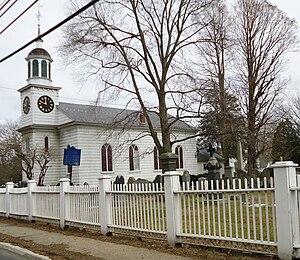
Christ Church (Episcopal), Shrewsbury
Historic church in New Jersey, United States
Distance: Approx. 1181 meters
Latitude and longitude: 40.32361111,-74.06111111
Christ Church (Episcopal), Shrewsbury is an historic church building at the junction of Broad Street and Sycamore Avenue in Shrewsbury, New Jersey, a location known as the historic "Four Corners" because the intersection hosts the Allen House, the Quaker Meeting House, the Presbyterian Church, and the Shrewsbury Historical Society / Borough Hall. The present church building was constructed in 1769 and added to the National Register of Historic Places in 1995. The congregation held its first mass in 1702 and it has been an active parish since.[1] The first female rector is the Mother Lisa Sauber Mitchell, who has served as Rector since 1997.[2] The building housed continental soldiers during the Revolutionary war.

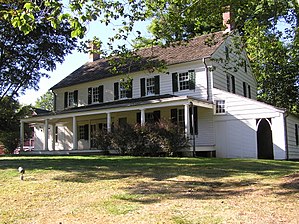
Allen House (Shrewsbury, New Jersey)
Historic house in New Jersey, United States
Distance: Approx. 1105 meters
Latitude and longitude: 40.32407,-74.06178
The Allen House is located in the borough of Shrewsbury in Monmouth County, New Jersey, United States. The historic house, which would later function as a tavern, was built around 1710 as a second residence for the Stillwell family of New York. Richard, a wealthy merchant, and his wife Mercy had eight children who were brought up primarily in Shrewsbury.

Wardell House (Shrewsbury, New Jersey)
Historic house in New Jersey, United States
Distance: Approx. 1129 meters
Latitude and longitude: 40.32277778,-74.06277778
Wardell House is located in Shrewsbury, Monmouth County, New Jersey, United States. The house was built in 1764 and was added to the National Register of Historic Places on July 24, 1974.
Red Bank Armory
Distance: Approx. 1951 meters
Latitude and longitude: 40.34722222,-74.07194444
The Red Bank Armory is a former armory located at 76 Chestnut Street in Red Bank, New Jersey that has been converted to ice rink. The armory was built in 1914 for Troop B of the National Guard's Red Bank Cavalry and featured a 100x144-foot equestrian riding hall. By the 1950s, it was used to store old tanks.
Parker Homestead
Historic house in New Jersey, United States
Distance: Approx. 1996 meters
Latitude and longitude: 40.34333333,-74.05722222
The Parker Homestead is a historic home and grounds in Little Silver, Monmouth County, New Jersey, United States, located at 235 Rumson Road near Sickles Park. The main house was originally built circa 1720, and includes materials from an earlier structure (c. 1667) the early and late 19th century, and the 1910s and 1920s.

Anthony Reckless Estate
Historic house and women's club
Distance: Approx. 1971 meters
Latitude and longitude: 40.3465402,-74.0653189
The Anthony Reckless Estate, now the Woman's Club of Red Bank, is a historic house in downtown Red Bank, New Jersey. It was completed in 1870 and it was added to both the National Register of Historic Places and the New Jersey Register of Historic Places in 1982.
Weather in this IP's area
overcast clouds
22 Celsius
23 Celsius
21 Celsius
23 Celsius
1009 hPa
68 %
1009 hPa
1008 hPa
10000 meters
5.14 m/s
300 degree
100 %
06:59:01
18:28:38