Country:
 USA
USARegion:
City:
Latitude and Longitude:
Time Zone:
Postal Code:
IP information under different IP Channel
ip-api
Country
Region
City
ASN
Time Zone
ISP
Blacklist
Proxy
Latitude
Longitude
Postal
Route
IPinfo
Country
Region
City
ASN
Time Zone
ISP
Blacklist
Proxy
Latitude
Longitude
Postal
Route
MaxMind
Country
Region
City
ASN
Time Zone
ISP
Blacklist
Proxy
Latitude
Longitude
Postal
Route
Luminati
Country
USASN
Time Zone
America/Chicago
ISP
RADIANZ-NUTLEY
Latitude
Longitude
Postal
db-ip
Country
Region
City
ASN
Time Zone
ISP
Blacklist
Proxy
Latitude
Longitude
Postal
Route
ipdata
Country
Region
City
ASN
Time Zone
ISP
Blacklist
Proxy
Latitude
Longitude
Postal
Route
Popular places and events near this IP address
Lyndhurst High School
High school in Bergen County, New Jersey, US
Distance: Approx. 1382 meters
Latitude and longitude: 40.810425,-74.126424
Lyndhurst High School is a four-year comprehensive public high school that serves students in ninth through twelfth grade from Lyndhurst, in Bergen County, in the U.S. state of New Jersey, operating as the lone secondary school of the Lyndhurst School District. As of the 2022–23 school year, the school had an enrollment of 824 students and 61.0 classroom teachers (on an FTE basis), for a student–teacher ratio of 13.5:1. There were 128 students (15.5% of enrollment) eligible for free lunch and 34 (4.1% of students) eligible for reduced-cost lunch.

Delawanna station
NJ Transit rail station
Distance: Approx. 1169 meters
Latitude and longitude: 40.8317,-74.1314
Delawanna is a commuter rail station for New Jersey Transit in the Delawanna section of Clifton, Passaic County, New Jersey. The station, located at the intersection of Delawanna Avenue (Passaic County Route 610) and Oak Street (County Route 605), serves trains on New Jersey Transit's Main Line, serving Hoboken Terminal on the east end and Suffern and Port Jervis stations on the west end in New York. Delawanna station has two low-level side platforms with a shelter on the inbound side, lacking access for the physically disabled under the Americans With Disabilities Act of 1990.
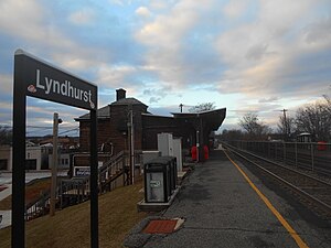
Lyndhurst station
NJ Transit rail station
Distance: Approx. 1009 meters
Latitude and longitude: 40.8163,-74.1242
Lyndhurst is a New Jersey Transit rail station located off of New York Avenue in Lyndhurst, New Jersey. The station is one of two in Lyndhurst, the other being Kingsland station. The Lyndhurst station is located at milepost 8.2 on the Main Line.

Rutt's Hut
Restaurant in Clifton, New Jersey, U.S.
Distance: Approx. 1075 meters
Latitude and longitude: 40.827,-74.1237
Rutt's Hut is a restaurant in Clifton, New Jersey known for its deep-fried hot dogs. In addition to the Ripper, customers can also order the dogs 'In-And-Out' style which is only in the hot oil briefly, and the 'Cremator' which is charred black. The original roadside stand was opened in 1928 by Royal "Abe" Rutt and his wife, Anna.
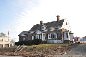
Jacob W. Van Winkle House
Historic house in New Jersey, United States
Distance: Approx. 574 meters
Latitude and longitude: 40.81638889,-74.1325
The Jacob W. Van Winkle House is located in Lyndhurst, Bergen County, in the U.S. state of New Jersey. The homestead was built in 1797 and is the current home of the Masonic Club of Lyndhurst. The homestead was added to the National Register of Historic Places on January 10, 1983.

River Road School
United States historic place
Distance: Approx. 744 meters
Latitude and longitude: 40.81472222,-74.13388889
The River Road School is located at 400 Riverside Avenue in the township of Lyndhurst in Bergen County, New Jersey, United States. The schoolhouse was built in 1893 and is the home of the Lyndhurst Historical Society. The schoolhouse was added to the National Register of Historic Places on November 11, 1977, for its significance in architecture and education.

Jeremiah J. Yeareance House
Historic house in New Jersey, United States
Distance: Approx. 653 meters
Latitude and longitude: 40.81555556,-74.13472222
The Jeremiah J. Yeareance House is located in Lyndhurst, Bergen County, New Jersey, United States. The house was built in 1804 and served as a residence for the teacher of River Road School. The house was added to the National Register of Historic Places on April 3, 1986.

Kingsland Manor
Historic house in New Jersey, United States
Distance: Approx. 937 meters
Latitude and longitude: 40.82638889,-74.14305556
The Kingsland Manor is a Dutch Colonial home with Federal-style elements located at 3 Kingsland Street in Nutley, Essex County, New Jersey, United States. The house was added to the National Register of Historic Places on March 24, 1978, for its significance in architecture, exploration/settlement, industry, and social history.

Van Riper House
Historic building in New Jersey, United States
Distance: Approx. 167 meters
Latitude and longitude: 40.8218354,-74.135997
The Van Riper House is a Bergen Dutch sandstone house located in Nutley, New Jersey, built in 1708. The building was owned in the 20th century by ITT Corporation and served as executives' residence and offices. In 2001, the building and 0.9 acres of land were transferred to the municipal government who then leased it to Van Riper House, Inc., a nonprofit corporation, for twenty years, with the intention that it would be restored and preserved.

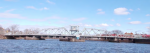
Lyndhurst Draw
Bridge in Clifton and Lyndhurst, New Jersey
Distance: Approx. 630 meters
Latitude and longitude: 40.8206,-74.1267
The Lyndhurst Draw is a railroad bridge crossing the Passaic River between Clifton and Lyndhurst in northeastern New Jersey. Built in 1903, it is owned and operated by New Jersey Transit Rail Operations (NJT). The swing bridge is situated between the Lyndhurst and Delawanna stations of NJT's Main Line, 8.52 miles (13.71 km) from its origination point at Hoboken Terminal, and 11.7 miles (18.8 km) from the river's mouth at Newark Bay.
Kingsland Avenue Bridge (Passaic River)
Bridge in Nutley and Lyndhurst, New Jersey
Distance: Approx. 1216 meters
Latitude and longitude: 40.811,-74.1385
Kingsland Avenue Bridge, earlier known as Avondale Bridge and designated the De Jessa Memorial Bridge, is a vehicular movable bridge over the Passaic River in northeastern New Jersey. It crosses the county line to connect the towns of Lyndhurst in Bergen and Nutley in Essex, originally taking its name from the Kingsland section. The bridge is 10.7 miles (17.2 km) from the river's mouth at Newark Bay, and is required to open on four hours' notice.

Eighth Street Bridge (Passaic River)
Bridge in Passaic and Wallington, New Jersey
Distance: Approx. 630 meters
Latitude and longitude: 40.8206,-74.1267
Eighth Street Bridge is a road bridge over the Passaic River in northeastern New Jersey, United States. It connects the City of Passaic in Passaic County with the Borough of Wallington in Bergen County and is jointly owned by both counties. The bridge connects Eighth Street in Passaic with County Route 507 in Wallington.
Weather in this IP's area
light rain
19 Celsius
19 Celsius
18 Celsius
21 Celsius
1009 hPa
78 %
1009 hPa
1009 hPa
10000 meters
5.14 m/s
230 degree
100 %
06:59:35
18:28:34