Country:
 USA
USARegion:
City:
Latitude and Longitude:
Time Zone:
Postal Code:
IP information under different IP Channel
ip-api
Country
Region
City
ASN
Time Zone
ISP
Blacklist
Proxy
Latitude
Longitude
Postal
Route
IPinfo
Country
Region
City
ASN
Time Zone
ISP
Blacklist
Proxy
Latitude
Longitude
Postal
Route
MaxMind
Country
Region
City
ASN
Time Zone
ISP
Blacklist
Proxy
Latitude
Longitude
Postal
Route
Luminati
Country
USASN
Time Zone
America/Chicago
ISP
INTERNAP-BLK3
Latitude
Longitude
Postal
db-ip
Country
Region
City
ASN
Time Zone
ISP
Blacklist
Proxy
Latitude
Longitude
Postal
Route
ipdata
Country
Region
City
ASN
Time Zone
ISP
Blacklist
Proxy
Latitude
Longitude
Postal
Route
Popular places and events near this IP address
New York Medical College
Medical school of Touro University
Distance: Approx. 1342 meters
Latitude and longitude: 41.085017,-73.810041
New York Medical College (NYMC or New York Med) is a private medical school in Valhalla, New York. Founded in 1860, it is a member of the Touro University System. NYMC offers advanced degrees through its three schools: the School of Medicine (SOM), the Graduate School of Biomedical Sciences (GSBMS) and the School of Health Sciences and Practice (SHSP).
Hackley School
Private, preparatory school in Tarrytown, New York, United States
Distance: Approx. 1865 meters
Latitude and longitude: 41.07011944,-73.84274722
Hackley School is a private college preparatory school located in Tarrytown, New York, and is a member of the Ivy Preparatory School League. Founded in 1899 by a wealthy philanthropist, Frances Hackley, the school was intended to be a Unitarian alternative to Episcopal boarding schools. Since its founding, Hackley has dropped its Unitarian affiliations and changed from all-boys to coeducational.
WXPK
Adult album alternative radio station in Briarcliff Manor, New York
Distance: Approx. 1426 meters
Latitude and longitude: 41.08027778,-73.80666667
WXPK (107.1 MHz), branded 107.1 The Peak, is a commercial radio station licensed to Briarcliff Manor, New York, and serving Westchester County, New York. It is owned by Pamal Broadcasting and broadcasts an Adult Album Alternative (AAA) radio format. The station's studios are in White Plains and its transmitter is off the Sprain Brook Parkway at the Westchester County Correctional Facility in Valhalla.

South County Trailway
Rail trail in New York
Distance: Approx. 1727 meters
Latitude and longitude: 41.06333333,-73.81916667
The South County Trailway is a 14.1-mile (22.7 km) long rail trail stretching from the Putnam Trail in Van Cortlandt Park in the Bronx to the North County Trailway in East View, New York. Westchester County Parks constructed the trailway in segments beginning in 1990 and completed it on October 31, 2017. The South County Trailway was constructed mostly along the main line of the former New York and Putnam Railroad railbed in Westchester County, New York (also known as "Westchester").
Eastview, New York
Business district in New York, United States
Distance: Approx. 591 meters
Latitude and longitude: 41.0815,-73.82930556
Eastview (or East View) is a business district and former hamlet in Mount Pleasant, Westchester County, New York, United States, located approximately 25 miles north of Midtown Manhattan. It was primarily residential, and had a post office, railroad station, and school. In the late 1920s, John D. Rockefeller Jr.
Captain Lawrence Brewing Company
Craft brewery located in Elmsford, New York
Distance: Approx. 1181 meters
Latitude and longitude: 41.07055556,-73.81416667
Captain Lawrence Brewing Company is a craft brewery located in Elmsford, New York. The brewery is owned and run by head brewer Scott Vaccaro. Vaccaro, a homebrewer since 1995, trained in brewing science at UC Davis.
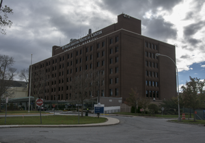
Westchester Medical Center
Hospital in New York, United States
Distance: Approx. 1739 meters
Latitude and longitude: 41.086133,-73.8054204
Westchester Medical Center University Hospital (WMC), formerly Grasslands Hospital, is an 895-bed Regional Trauma Center providing health services to residents of the Hudson Valley, northern New Jersey, and southern Connecticut. It is known for having one of the highest case mix index rates of all hospitals in the United States. 652 beds are at the hospital's primary location in Valhalla, while the other 243 beds are at the MidHudson Regional Hospital campus in Poughkeepsie.

Maria Fareri Children's Hospital
Hospital in NY, United States
Distance: Approx. 1776 meters
Latitude and longitude: 41.08608,-73.804877
Maria Fareri Children's Hospital, a member of the Westchester Medical Center Health Network (WMCHealth), is the advanced care pediatric hospital for New York's Hudson Valley region and Fairfield County, Connecticut. Maria Fareri Children's Hospital is part of the Valhalla, NY campus of WMCHealth along with Westchester Medical Center and the Behavioral Health Center. It is home to hundreds of clinical and surgical pediatric specialists in almost every medical field.

Tarrytown Reservoir
Reservoir in Tarrytown, New York
Distance: Approx. 1553 meters
Latitude and longitude: 41.08277778,-73.84111111
The Tarrytown Reservoir is an 81 acres (0.33 km2) storage reservoir in Tarrytown, New York. It was completed in 1897 by the Village of Tarrytown as the village's main storage reservoir. The reservoir was formed by the Tarrytown Waterworks Dam which impounded a tributary of the Saw Mill River.

Hammond House (Eastview, New York)
Historic house in New York, United States
Distance: Approx. 1028 meters
Latitude and longitude: 41.07611111,-73.81166667
The Hammond House is located on Grasslands Road (New York State Route 100C) in the Eastview section of the town of Mount Pleasant, New York, United States. It is a wooden building whose oldest part dates to the 1720s, with latter additions during the 19th century. In 1980 it was added to the National Register of Historic Places.
Catskill-Delaware Water Ultraviolet Disinfection Facility
Water treatment facility in New York, US
Distance: Approx. 1235 meters
Latitude and longitude: 41.078,-73.8088
The Catskill-Delaware Water Ultraviolet Disinfection Facility is a 160,000-square-foot (15,000 m2) ultraviolet (UV) water disinfection plant built in Westchester County, New York to disinfect water for the New York City water supply system. The compound is the largest ultraviolet germicidal irradiation plant in the world. The UV facility treats water delivered by two of the city's aqueduct systems, the Catskill Aqueduct and the Delaware Aqueduct, via the Kensico Reservoir.
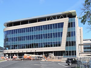
Touro College of Dental Medicine
Distance: Approx. 915 meters
Latitude and longitude: 41.085348,-73.817459
Touro College of Dental Medicine is a school of dentistry in Valhalla, New York on the New York Medical College campus. The school is a division of the Touro College and University System. The school is the fifth dental school in New York State and is the third private dental school in New York, along with NYU and Columbia.
Weather in this IP's area
light rain
18 Celsius
18 Celsius
17 Celsius
19 Celsius
1009 hPa
83 %
1009 hPa
1002 hPa
10000 meters
1.54 m/s
260 degree
100 %
06:58:30
18:27:09