209.189.233.76 - IP Lookup: Free IP Address Lookup, Postal Code Lookup, IP Location Lookup, IP ASN, Public IP
Country:
Region:
City:
Location:
Time Zone:
Postal Code:
ISP:
ASN:
language:
User-Agent:
Proxy IP:
Blacklist:
IP information under different IP Channel
ip-api
Country
Region
City
ASN
Time Zone
ISP
Blacklist
Proxy
Latitude
Longitude
Postal
Route
db-ip
Country
Region
City
ASN
Time Zone
ISP
Blacklist
Proxy
Latitude
Longitude
Postal
Route
IPinfo
Country
Region
City
ASN
Time Zone
ISP
Blacklist
Proxy
Latitude
Longitude
Postal
Route
IP2Location
209.189.233.76Country
Region
texas
City
austin
Time Zone
America/Chicago
ISP
Language
User-Agent
Latitude
Longitude
Postal
ipdata
Country
Region
City
ASN
Time Zone
ISP
Blacklist
Proxy
Latitude
Longitude
Postal
Route
Popular places and events near this IP address
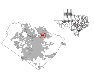
Wells Branch, Texas
CDP in Texas, United States
Distance: Approx. 70 meters
Latitude and longitude: 30.44388889,-97.67833333
Wells Branch is a census-designated place (CDP) in Travis County, Texas, United States. The population was 14,000 at the 2020 census.

Windermere, Texas
Former CDP in Texas, United States
Distance: Approx. 2393 meters
Latitude and longitude: 30.45805556,-97.66055556
Windermere is a former census-designated place (CDP) in Travis County, Texas, United States. The population was 1,037 at the 2010 census. It has since largely been annexed by the city of Pflugerville.

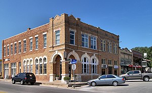
Pflugerville, Texas
City in Texas, United States
Distance: Approx. 4045 meters
Latitude and longitude: 30.4575,-97.64
Pflugerville ( FLOO-gər-vil) is a city in Travis County, Texas, United States, with a small portion in Williamson County. The population was 65,191 at the 2020 census. Pflugerville is a suburb of Austin and part of the Austin–Round Rock– Metropolitan Statistical Area.

McNeil, Travis County, Texas
Unincorporated community in Texas, United States
Distance: Approx. 4137 meters
Latitude and longitude: 30.45305556,-97.72055556
McNeil is an unincorporated community in Travis County, Texas, United States. According to the Handbook of Texas, the community had a population of 70 in 2000. It is located within the Greater Austin Metropolitan area.
Cook-Walden Capital Parks Cemetery
Cemetery in Travis County, Texas
Distance: Approx. 1434 meters
Latitude and longitude: 30.437,-97.666
Cook-Walden Capital Parks Cemetery (also known as Capital Memorial Park and Capital Memorial Park Cemetery) is a cemetery located in Pflugerville, Texas, United States a suburb of Austin, Texas.
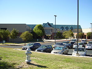
John B. Connally High School
Public high school in Austin, Texas, United States
Distance: Approx. 2760 meters
Latitude and longitude: 30.4188,-97.6764
John B. Connally High School is a public secondary school in Austin, Texas, United States. The school, which opened in 1996, serves 9–12 and is part of the Pflugerville Independent School District.

Howard station (CapMetro Rail)
Hybrid rail station in Austin, Texas
Distance: Approx. 2157 meters
Latitude and longitude: 30.440282,-97.701067
Howard station is a CapMetro Rail hybrid rail station in Austin, Texas. It is located in Northwest Austin at the corner of Howard Lane and MoPac Expressway. Howard includes a Park & Ride with 200 spaces.

La Frontera (Round Rock, Texas)
Distance: Approx. 4399 meters
Latitude and longitude: 30.48277778,-97.68388889
La Frontera is a mixed-use development in Round Rock, Texas. It consists of retail, residential and office properties. The name "La Frontera" means "the border" or "frontier" in Spanish, referring to the development's location on the border of Travis and Williamson counties.
Chaparral Star Academy
Public high school in Austin, Texas, United States
Distance: Approx. 1378 meters
Latitude and longitude: 30.437999,-97.691764
Chaparral Star Academy is a public charter school in Austin, Texas. It is an open-enrollment, publicly funded charter school in Austin, Texas. The students often participate in out-of-school activities, such as national figure skating, gymnastics, and equestrian competitions.

Waters Park, Texas
Distance: Approx. 3799 meters
Latitude and longitude: 30.41805556,-97.70527778
Waters Park (also known as Waters and Watters) was a village located eight miles north of downtown Austin, Texas defined by the boundaries of Farm to Market Road 1325, MoPac, and the Southern Pacific Railroad. It is now part of the City of Austin.
Three Points, Texas
Unincorporated community in Texas, United States
Distance: Approx. 1841 meters
Latitude and longitude: 30.45166667,-97.66222222
Three Points is an unincorporated community in Travis County, in the U.S. state of Texas. It is located within the Greater Austin metropolitan area.
Ramen Del Barrio
Restaurant in Austin, Texas, U.S.
Distance: Approx. 3493 meters
Latitude and longitude: 30.412838,-97.686618
Ramen Del Barrio is a restaurant in Austin, Texas, United States. It was a semifinalist in the Best New Restaurant category of the James Beard Foundation Awards in 2024.
Weather in this IP's area
clear sky
10 Celsius
8 Celsius
9 Celsius
12 Celsius
1026 hPa
28 %
1026 hPa
999 hPa
10000 meters
2.57 m/s
180 degree
