Country:
Region:
City:
Latitude and Longitude:
Time Zone:
Postal Code:
IP information under different IP Channel
ip-api
Country
Region
City
ASN
Time Zone
ISP
Blacklist
Proxy
Latitude
Longitude
Postal
Route
Luminati
Country
ASN
Time Zone
America/Chicago
ISP
CCH1-IPV4-01
Latitude
Longitude
Postal
IPinfo
Country
Region
City
ASN
Time Zone
ISP
Blacklist
Proxy
Latitude
Longitude
Postal
Route
db-ip
Country
Region
City
ASN
Time Zone
ISP
Blacklist
Proxy
Latitude
Longitude
Postal
Route
ipdata
Country
Region
City
ASN
Time Zone
ISP
Blacklist
Proxy
Latitude
Longitude
Postal
Route
Popular places and events near this IP address

Cathedral Basilica of Our Lady of Peace
Historic Roman Catholic church in Hawaii, United States
Distance: Approx. 175 meters
Latitude and longitude: 21.31075,-157.859417
The Cathedral Basilica of Our Lady of Peace is the mother church and cathedral of the Diocese of Honolulu.

Washington Place
United States historic place
Distance: Approx. 176 meters
Latitude and longitude: 21.30881667,-157.85676667
Washington Place is a Greek Revival palace in the Hawaii Capital Historic District in Honolulu, Hawaii. It was where Queen Liliʻuokalani was arrested during the overthrow of the Hawaiian Kingdom. Later it became the official residence of the governor of Hawaii.

Keōua Hale
Distance: Approx. 137 meters
Latitude and longitude: 21.31076667,-157.85706667
Keōua Hale was the mansion of Princess Ruth Keʻelikōlani at 1302 Queen Emma Street in downtown Honolulu, Hawaii.

Cathedral Church of Saint Andrew (Honolulu)
Historic church in Hawaii, United States
Distance: Approx. 83 meters
Latitude and longitude: 21.30972222,-157.85722222
The Cathedral Church of Saint Andrew, also commonly known as St. Andrew's Cathedral, is a cathedral of the Episcopal Church in the United States located in the State of Hawaii. Originally the seat of the Anglican Church of Hawaii, it is now the home of the bishop of the Episcopal Diocese of Hawaii.

Hawaii Pacific University
Private university in Hawaii, U.S.
Distance: Approx. 160 meters
Latitude and longitude: 21.311,-157.859
Hawaiʻi Pacific University (HPU) is a private university in Honolulu, Hawaiʻi. Oceanic Institute of HPU, an aquaculture research facility, is located at Makapuʻu Point. HPU is also present on military installations on the island of Oʻahu.
Episcopal Diocese of Hawaii
Diocese of the Episcopal Church in the United States
Distance: Approx. 66 meters
Latitude and longitude: 21.309777,-157.857375
The Episcopal Diocese of Hawai'i is the ecclesiastical territory or diocese of the Episcopal Church of the Anglican Communion in the United States encompassing the state of Hawaii and Episcopal congregations in Micronesia. It is led by the Episcopal Bishop of Hawaii pastoring the Hawaiian Islands from the Cathedral Church of Saint Andrew in Honolulu. The territorial jurisdiction which the Episcopal Diocese of Honolulu holds today was given up to American Episcopalians after the 1893 overthrow of Queen Liliuokalani, head of the Church of Hawaii.
KDNN
Radio station in Honolulu, Hawaii
Distance: Approx. 138 meters
Latitude and longitude: 21.31044444,-157.85919444
KDNN (98.5 FM, "Island 98.5") is a hawaiian contemporary hit radio formatted radio station based in Honolulu, Hawaii. The iHeartMedia, Inc. outlet broadcasts with an ERP of 51 kW. It also transmits on Oceanic Spectrum digital channel 851 for the entire state of Hawaii.
No. 1 Capitol District Building
Building in Honolulu, Hawaii, United States
Distance: Approx. 148 meters
Latitude and longitude: 21.30861111,-157.85833333
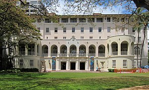
The No. 1 Capitol District Building, also known as the Hemmeter Building, is a 134,000-square-foot building (12,400 m2) on two acres (0.81 ha) in downtown Honolulu, Hawaii, United States. Formerly known as the Armed Services YMCA Building, it houses the Capitol Modern Museum, the Hawaii State Foundation on Culture and the Arts, and state offices.

Kauikeaouli Hale
District courthouse for the Island of Oʻahu in Hawaii
Distance: Approx. 129 meters
Latitude and longitude: 21.30888889,-157.85861111
Kauikeaouli Hale is a district courthouse for the Island of Oʻahu in Hawaii. It is located at 1111 Alakea Street between downtown Honolulu and the Hawaii Capital Historic District at 21°18′32″N 157°51′31″W. Its lower floors house the courts of the first circuit, covering the City and County of Honolulu, and upper floors have offices of some support departments of the Hawaii Supreme Court. It is adjacent to the Hawaii State Art Museum.

Alexander Young Hotel
United States historic place
Distance: Approx. 250 meters
Latitude and longitude: 21.30916667,-157.86027778
The Alexander Young Hotel was one of the first hotels in downtown Honolulu, Hawaii, opened in 1903. The hotel closed and was converted to offices in 1964. The structure was demolished in 1981.
Princess Ruth Keʻelikōlani Middle School
United States historic place
Distance: Approx. 216 meters
Latitude and longitude: 21.31138889,-157.85666667
Princess Ruth Keʻelikōlani Middle School (formerly Central Grammar School, Central Intermediate School, and Central Middle School) is a school of the Hawaii Department of Education that occupies a historic building in Honolulu, Hawaiʻi, built on the grounds of Keōua Hale, the former palace of Princess Ruth Keʻelikōlani of Hawaiʻi.
Capitol Modern
Museum in Honolulu, Hawaii, United States
Distance: Approx. 148 meters
Latitude and longitude: 21.30861111,-157.85833333
The Capitol Modern Museum, formerly (until 2023) named the Hawaii State Art Museum, is a small art gallery located on the second floor of the No. 1 Capitol District Building in downtown Honolulu, Hawaii, United States. Long known as HiSAM, the museum is operated by the Hawaii State Foundation on Culture and the Arts.
Weather in this IP's area
few clouds
28 Celsius
29 Celsius
27 Celsius
28 Celsius
1020 hPa
65 %
1020 hPa
1018 hPa
10000 meters
6.71 m/s
12.52 m/s
70 degree
20 %
06:43:28
17:49:30

