Country:
 USA
USARegion:
City:
Latitude and Longitude:
Time Zone:
Postal Code:
IP information under different IP Channel
ip-api
Country
Region
City
ASN
Time Zone
ISP
Blacklist
Proxy
Latitude
Longitude
Postal
Route
IPinfo
Country
Region
City
ASN
Time Zone
ISP
Blacklist
Proxy
Latitude
Longitude
Postal
Route
MaxMind
Country
Region
City
ASN
Time Zone
ISP
Blacklist
Proxy
Latitude
Longitude
Postal
Route
Luminati
Country
USRegion
la
City
mandeville
ASN
Time Zone
America/Chicago
ISP
NTSC-ASN2
Latitude
Longitude
Postal
db-ip
Country
Region
City
ASN
Time Zone
ISP
Blacklist
Proxy
Latitude
Longitude
Postal
Route
ipdata
Country
Region
City
ASN
Time Zone
ISP
Blacklist
Proxy
Latitude
Longitude
Postal
Route
Popular places and events near this IP address

Mandeville, Louisiana
City in Louisiana, United States
Distance: Approx. 2415 meters
Latitude and longitude: 30.36916667,-90.07805556
Mandeville is a city in St. Tammany Parish, Louisiana, United States. As of the 2020 United States census, its population was 13,192.

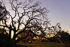
Seven Sisters Oak
Southern live oak in Mandeville, Louisiana
Distance: Approx. 4208 meters
Latitude and longitude: 30.36722222,-90.09875
Seven Sisters Oak, located in Mandeville, Louisiana, is a notably large southern live oak in Louisiana. The tree was originally registered at the Live Oak Society as "Doby's Seven Sisters" (No. 200) because the Doby family owned the property where the tree was located and Mrs.

Mandeville High School
Public school in Mandeville, LA, United States
Distance: Approx. 5040 meters
Latitude and longitude: 30.3813,-90.1015
Mandeville High School is a public high school located in Mandeville, Louisiana, United States, a suburban city located thirty miles north of New Orleans. It is part of the St. Tammany Parish Public Schools system.
Fontainebleau State Park
State park in Louisiana, United States
Distance: Approx. 3538 meters
Latitude and longitude: 30.34523,-90.02269
Fontainebleau State Park is located in St. Tammany Parish, Louisiana, on the north shore of Lake Pontchartrain. The park is 2,800 acres (1,100 ha) in size and was once the site of a sugar cane plantation and brickyard operated by Bernard de Marigny and later by his son Armand Marigny.
Chinchuba, Louisiana
Unincorporated community in Louisiana
Distance: Approx. 3911 meters
Latitude and longitude: 30.38722222,-90.07972222
Chinchuba (also Ozone Park) is an unincorporated community in St. Tammany Parish, Louisiana, United States. The community is on U.S. Route 190 just northwest of Mandeville.

Dew Drop Social and Benevolent Hall
United States historic place
Distance: Approx. 679 meters
Latitude and longitude: 30.35555556,-90.06222222
The Dew Drop Social and Benevolent Hall, in Mandeville, Louisiana, was built in 1895. It was home of the 1885-founded mutual assistance/social organization, the "Dew Drop Social and Benevolent No. 2 of Mandeville".
Bayou Castine
Stream in Louisiana, U.S.
Distance: Approx. 2983 meters
Latitude and longitude: 30.36429,-90.02575
Bayou Castine is a stream in the U.S. state of Louisiana.
Lewisburg, Louisiana
Census-designated place in Louisiana, United States
Distance: Approx. 4677 meters
Latitude and longitude: 30.36972222,-90.10305556
Lewisburg is an unincorporated community and census-designated place in St. Tammany Parish, Louisiana, United States. The community is located 7 miles (11.27 kilometres) south of Covington, Louisiana.
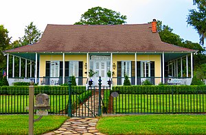
Bertus-Ducatel House
United States historic place
Distance: Approx. 1179 meters
Latitude and longitude: 30.35083333,-90.06444444
The Bertus-Ducatel House, at 1721 Lakeshore Dr. in Mandeville, Louisiana, was built around 1839. It was listed on the National Register of Historic Places in 1998.
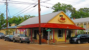
Griffin's Bakery
United States historic place
Distance: Approx. 1138 meters
Latitude and longitude: 30.355833,-90.0675
The Griffin's Bakery, in Mandeville in St. Tammany Parish, Louisiana, was built around 1900. It is a galleried corner commercial building located two blocks from Lake Pontchartrain in "Old Mandeville", a late nineteenth/early twentieth century neighborhood.
Johnson House (Mandeville, Louisiana)
United States historic place
Distance: Approx. 1099 meters
Latitude and longitude: 30.357778,-90.0675
The Johnson House, in Mandeville in St. Tammany Parish, Louisiana, was substantially built c.1915, redeveloping from a c.1890 predecessor. It is located three blocks from Lake Pontchartrain.
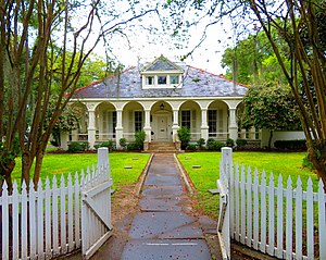
Morel-Nott House
United States historic place
Distance: Approx. 2234 meters
Latitude and longitude: 30.35851,-90.07936
The Morel-Nott House, on Lake Pontchartrain in Mandeville in St. Tammany Parish, Louisiana, was listed on the National Register of Historic Places in 2019. It is a French Creole raised cottage which was built in the 1830s or 1840s.
Weather in this IP's area
few clouds
31 Celsius
37 Celsius
30 Celsius
32 Celsius
1011 hPa
65 %
1011 hPa
1011 hPa
10000 meters
1.79 m/s
2.68 m/s
224 degree
17 %
06:45:33
19:04:25