Country:
 USA
USARegion:
City:
Latitude and Longitude:
Time Zone:
Postal Code:
IP information under different IP Channel
ip-api
Country
Region
City
ASN
Time Zone
ISP
Blacklist
Proxy
Latitude
Longitude
Postal
Route
IPinfo
Country
Region
City
ASN
Time Zone
ISP
Blacklist
Proxy
Latitude
Longitude
Postal
Route
MaxMind
Country
Region
City
ASN
Time Zone
ISP
Blacklist
Proxy
Latitude
Longitude
Postal
Route
Luminati
Country
USRegion
la
City
hammond
ASN
Time Zone
America/Chicago
ISP
NTSC-ASN2
Latitude
Longitude
Postal
db-ip
Country
Region
City
ASN
Time Zone
ISP
Blacklist
Proxy
Latitude
Longitude
Postal
Route
ipdata
Country
Region
City
ASN
Time Zone
ISP
Blacklist
Proxy
Latitude
Longitude
Postal
Route
Popular places and events near this IP address

Natalbany, Louisiana
CDP in Louisiana, United States
Distance: Approx. 2511 meters
Latitude and longitude: 30.54777778,-90.48388889
Natalbany is a census-designated place (CDP) in Tangipahoa Parish, Louisiana, United States. The population was 1,739 at the 2000 census. It is part of the Hammond Micropolitan Statistical Area.
Southeastern Louisiana University
Public university in Hammond, Louisiana, US
Distance: Approx. 1600 meters
Latitude and longitude: 30.51388889,-90.46833333
Southeastern Louisiana University (Southeastern) is a public university in Hammond, Louisiana. It was founded in 1925 by Linus A. Sims as Hammond Junior College. Sims succeeded in getting the campus moved to north Hammond in 1928, when it became known as Southeastern Louisiana College.

Pride Roofing University Center
Distance: Approx. 798 meters
Latitude and longitude: 30.52,-90.47277778
The University Center is a 7,500-seat multi-purpose arena in Hammond, Louisiana, United States, on the campus Southeastern Louisiana University. Often called "the UC" within the university, it was built in 1982 at a cost of $16.3 million. It is home to Southeastern Louisiana University's Lions and Lady Lions basketball teams and Lady Lions volleyball team.

Strawberry Stadium
Louisiana stadium
Distance: Approx. 1894 meters
Latitude and longitude: 30.51083333,-90.46833333
Strawberry Stadium is a 7,408-seat football/soccer stadium in Hammond, Louisiana. It is home to the Southeastern Louisiana University Lions American football team. The stadium also hosts St.

Hammond station (Louisiana)
Train station in Hammond, Louisiana, US
Distance: Approx. 2558 meters
Latitude and longitude: 30.5072,-90.462
Hammond station is an Amtrak train station in Hammond, Louisiana, United States. It is a station on Amtrak's daily City of New Orleans route which runs between Chicago and New Orleans. The Illinois Central Railroad built the station in 1912.
Saint Thomas Aquinas Regional Catholic High School
Private, coeducational school in Hammond, , Louisiana, United States
Distance: Approx. 1076 meters
Latitude and longitude: 30.52916667,-90.48805556
Saint Thomas Aquinas Regional Catholic High School is a private, Roman Catholic high school in unincorporated Tangipahoa Parish, Louisiana, near Hammond. It is located in the Roman Catholic Diocese of Baton Rouge.
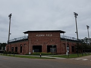
Pat Kenelly Diamond at Alumni Field
Distance: Approx. 1948 meters
Latitude and longitude: 30.50938889,-90.47077778
Pat Kenelly Diamond at Alumni Field is a baseball venue in Hammond, Louisiana, United States. It is home to the Southeastern Louisiana Lions baseball team of the NCAA's Division I Southland Conference. The facility has a capacity of 2,500 spectators.
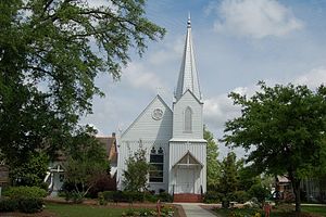
Grace Memorial Episcopal Church (Hammond, Louisiana)
Historic church in Louisiana, United States
Distance: Approx. 2566 meters
Latitude and longitude: 30.506941,-90.462276
Grace Memorial Episcopal Church is a historic church at 100 W. Church Street in Hammond, Louisiana, U.S.A. It was built in 1876, consecrated in 1888, and added to the National Register of Historic Places in 1973.

North Oak Park
Distance: Approx. 224 meters
Latitude and longitude: 30.52416667,-90.47630556
North Oak Park is the home stadium for the Division I (NCAA) Southeastern Louisiana Lady Lions softball team. The stadium is located on the campus of Southeastern Louisiana University in Hammond, Louisiana. Amenities include bleacher seating for 500 fans; field lighting; a brick wall along the foul lines; an electronic scoreboard; dugouts; outdoor batting cages; concessions; restrooms; and locker rooms.
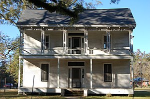
Randal House
Historic house in Louisiana, United States
Distance: Approx. 2329 meters
Latitude and longitude: 30.51138889,-90.46
The Randal House is a historic mansion in Hammond, Louisiana, U.S.. It has been listed on the National Register of Historic Places since February 19, 2008.
Wascom House
United States historic place
Distance: Approx. 2349 meters
Latitude and longitude: 30.51138889,-90.45972222
The Wascom House, at 303 E. Michigan Ave. in Hammond, Louisiana, was built around 1897. It was listed on the National Register of Historic Places in 2008.
Oaks Hotel
United States historic place
Distance: Approx. 1983 meters
Latitude and longitude: 30.51416667,-90.46194444
Oaks Hotel, in Hammond, Louisiana, was built in 1905. It is an L-shaped building that was listed on the National Register of Historic Places in 1979. It was designed by Favrot & Livaudais, an architectural firm active in Louisiana from 1891 to 1933.
Weather in this IP's area
broken clouds
31 Celsius
34 Celsius
30 Celsius
32 Celsius
1011 hPa
58 %
1011 hPa
1010 hPa
10000 meters
2.06 m/s
340 degree
75 %
06:47:12
19:06:09