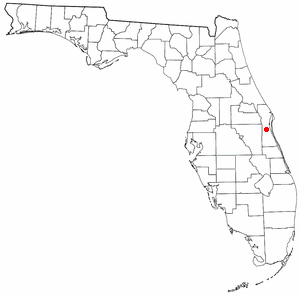
209.151.210.99 - IP Lookup: Free IP Address Lookup, Postal Code Lookup, IP Location Lookup, IP ASN, Public IP
Country:
Region:
City:
Location:
Time Zone:
Postal Code:
IP information under different IP Channel
ip-api
Country
Region
City
ASN
Time Zone
ISP
Blacklist
Proxy
Latitude
Longitude
Postal
Route
Luminati
Country
Region
fl
City
melbourne
ASN
Time Zone
America/New_York
ISP
SATCOM-DIRECT-INC
Latitude
Longitude
Postal
IPinfo
Country
Region
City
ASN
Time Zone
ISP
Blacklist
Proxy
Latitude
Longitude
Postal
Route
IP2Location
209.151.210.99Country
Region
florida
City
melbourne
Time Zone
America/New_York
ISP
Language
User-Agent
Latitude
Longitude
Postal
db-ip
Country
Region
City
ASN
Time Zone
ISP
Blacklist
Proxy
Latitude
Longitude
Postal
Route
ipdata
Country
Region
City
ASN
Time Zone
ISP
Blacklist
Proxy
Latitude
Longitude
Postal
Route
Popular places and events near this IP address

Palm Shores, Florida
Town in the state of Florida, United States
Distance: Approx. 4886 meters
Latitude and longitude: 28.19083333,-80.65944444
Palm Shores is a town in Brevard County, Florida. It is part of the Palm Bay–Melbourne–Titusville, Florida Metropolitan Statistical Area. The population was 1,200 at the 2020 US Census, up from 900 at the 2010 census.

Brevard Zoo
Zoo in Florida, United States
Distance: Approx. 2443 meters
Latitude and longitude: 28.225089,-80.713978
Brevard Zoo is a 75-acre nonprofit facility located in Melbourne, Florida, United States, that is home to more than 800 animals representing more than 170 species from Florida, South America, Africa, Asia, and Australia. The zoo features animal feedings, kayak tours, behind-the-scenes tours, and a train ride, along with the attraction Treetop Trek. The zoo has also featured a dinosaur exhibit several times in its past, including one titled "Dinosaurs are Back", which ran from November 2017 to April 2018.
USSSA Space Coast Complex
Distance: Approx. 6014 meters
Latitude and longitude: 28.25694444,-80.73944444
USSSA Space Coast Complex is a baseball stadium and 13 diamond multi-sports facility in Viera, Florida, owned by Brevard County, Florida. Under its original name, Space Coast Stadium, it served as the spring training facility for the Florida Marlins (1994–2002), Montreal Expos (2003–2004), and Washington Nationals (2005–2016) and as the home field of the Brevard County Manatees (1994–2016). After a full year of renovations, it officially reopened in 2017 with its new name as a baseball/softball venue – part of a new multi-sport complex operated by the United States Specialty Sports Association (USSSA).

Viera, Florida
Planned community in Florida, United States
Distance: Approx. 5949 meters
Latitude and longitude: 28.266401,-80.728934
Viera () is a planned community located in the central coastal region of Brevard County, Florida. It is part of an unincorporated section adjacent to the Melbourne, Florida area. However, Viera is actually much closer to Cocoa than to Melbourne.
Brevard Public Schools
School district in Florida, United States
Distance: Approx. 5218 meters
Latitude and longitude: 28.24822222,-80.73601111
Brevard Public Schools is a school district serving Brevard County, Florida, and based in Viera, Florida. In 2015, the district had about 74,000 students. 24% attend a school other than the one to which they are assigned.
United States Specialty Sports Association
Distance: Approx. 6014 meters
Latitude and longitude: 28.25694444,-80.73944444
The United States Specialty Sports Association (USSSA) is a volunteer, sports governing body and a nonprofit organization[2][3] based in Viera, Florida. Originally USSSA stood for United States Slowpitch Softball Association. However, in 1998, USSSA rebranded the name to United States Specialty Sports Association, because it expanded into other sports, including youth girls fastpitch, boys baseball, youth basketball, martial arts and more.

Lotus, Florida
Human settlement in Brevard County, Florida, United States of America
Distance: Approx. 5005 meters
Latitude and longitude: 28.21083333,-80.64111111
Lotus is a former village in Brevard County, Florida, United States. It is the location of Honeymoon Hill, the highest point on Merritt Island. Only one road runs through the area, CR 3, accessible to the south by Pineda Causeway and from the north via Florida State Road 520.

King Center for the Performing Arts
Distance: Approx. 6508 meters
Latitude and longitude: 28.1703,-80.6693
The King Center or the Maxwell C. King Center for the Performing Arts is a performing arts venue located at 3865 North Wickham Road, Melbourne, Florida. The main theater of the 126,000 square feet (11,700 m2) facility contains 2,016 seats. There is also a 250-seat venue named the Studio Theatre or the Black Box in the facility.
WLRQ-FM
Radio station in Cocoa, Florida
Distance: Approx. 5927 meters
Latitude and longitude: 28.27833333,-80.70083333
WLRQ-FM (99.3 MHz "Lite Rock 99.3") is a commercial radio station licensed to Cocoa, Florida, and serving the Space Coast including Melbourne and Brevard County. The station is owned by iHeartMedia, Inc.. It broadcasts an adult contemporary radio format, switching to Christmas music for much of November and December.
Viera High School
Public high school in Viera, Florida, United States
Distance: Approx. 5449 meters
Latitude and longitude: 28.252374,-80.735975
Viera High School is a public high school located in Viera, Florida, United States. It is part of the Brevard County School District.
Viera East, Florida
CDP in Florida, United States
Distance: Approx. 5204 meters
Latitude and longitude: 28.26527778,-80.71805556
Viera East is a census-designated place (CDP) in Brevard County, Florida, United States. The population was 11,687 at the 2020 census, up from 10,757 at the 2010 census. It forms a part of the larger unincorporated community of Viera and is part of the Palm Bay–Melbourne–Titusville Metropolitan, Florida Statistical Area.
Viera West, Florida
CDP in Florida, United States
Distance: Approx. 5335 meters
Latitude and longitude: 28.2475,-80.73777778
Viera West is a census-designated place (CDP) in Brevard County, Florida, United States. The population was 16,688 at the 2020 census, up from 6,641 at the 2010 census. It forms a part of the larger unincorporated community of Viera and is part of the Palm Bay–Melbourne–Titusville, Florida Metropolitan Statistical Area.
Weather in this IP's area
clear sky
6 Celsius
4 Celsius
6 Celsius
7 Celsius
1018 hPa
85 %
1018 hPa
1017 hPa
10000 meters
3.09 m/s
310 degree