209.137.196.27 - IP Lookup: Free IP Address Lookup, Postal Code Lookup, IP Location Lookup, IP ASN, Public IP
Country:
 USA
USARegion:
City:
Location:
Time Zone:
Postal Code:
ISP:
ASN:
language:
User-Agent:
Proxy IP:
Blacklist:
IP information under different IP Channel
ip-api
Country
Region
City
ASN
Time Zone
ISP
Blacklist
Proxy
Latitude
Longitude
Postal
Route
db-ip
Country
Region
City
ASN
Time Zone
ISP
Blacklist
Proxy
Latitude
Longitude
Postal
Route
IPinfo
Country
Region
City
ASN
Time Zone
ISP
Blacklist
Proxy
Latitude
Longitude
Postal
Route
IP2Location
209.137.196.27Country
usRegion
kansas
City
goddard
Time Zone
America/Chicago
ISP
Language
User-Agent
Latitude
Longitude
Postal
ipdata
Country
Region
City
ASN
Time Zone
ISP
Blacklist
Proxy
Latitude
Longitude
Postal
Route
Popular places and events near this IP address

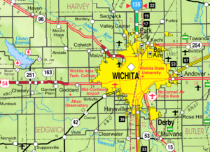
Goddard, Kansas
City in Sedgwick County, Kansas
Distance: Approx. 100 meters
Latitude and longitude: 37.65972222,-97.57416667
Goddard is a city in Sedgwick County, Kansas, United States, and a west suburb of Wichita. As of the 2020 census, the population of the city was 5,084.

Afton Township, Sedgwick County, Kansas
Township in Kansas, United States
Distance: Approx. 8053 meters
Latitude and longitude: 37.60277778,-97.63166667
Afton Township is a township in Sedgwick County, Kansas, United States. As of the 2000 United States Census, it had a population of 1,290.

Lake Afton Public Observatory
Observatory
Distance: Approx. 6174 meters
Latitude and longitude: 37.6222,-97.6269
Lake Afton Public Observatory (LAPO) is an astronomical observatory located southwest of Wichita, Kansas in a rural area of Sedgwick County on the north side of Lake Afton. At the heart of the observatory is a 16-inch (410 mm) F/13 Ritchey–Chrétien telescope along with a piggyback mounted 6-inch (150 mm) F/8 apochromatic refractor. The facility also features an exhibit room filled with educational material on stargazing, the physics of light, and the history of Astronomy.
Lake Afton
Lake in Sedgwick County, Kansas
Distance: Approx. 7062 meters
Latitude and longitude: 37.61138889,-97.62722222
Lake Afton is a 258-acre (104 ha) man-made recreational lake in Sedgwick County, Kansas, United States, and within the 720-acre (2.9 km2) Lake Afton Park. It is located east of the intersection of Viola Rd (263rd St W) and MacArthur Rd (39th St S), between the communities of Goddard, Garden Plain, Schulte, Viola.
Goddard High School (Kansas)
High school in Goddard, Kansas, United States
Distance: Approx. 1530 meters
Latitude and longitude: 37.647,-97.56866
Goddard High School is a public high school located in Goddard, Kansas, United States. It is operated by Goddard USD 265 school district and serves students in grades 9 to 12. It is one of two high schools located within the city limits of Goddard.

Attica Township, Sedgwick County, Kansas
Township in Kansas, United States
Distance: Approx. 5138 meters
Latitude and longitude: 37.69305556,-97.535
Attica Township is a township in Sedgwick County, Kansas, United States. As of the 2000 United States Census, it had a population of 4,959.

Garden Plain Township, Sedgwick County, Kansas
Township in Kansas, United States
Distance: Approx. 7051 meters
Latitude and longitude: 37.69305556,-97.64333333
Garden Plain Township is a township in Sedgwick County, Kansas, United States. As of the 2000 United States Census, it had a population of 1,780.

Illinois Township, Sedgwick County, Kansas
Township in Kansas, United States
Distance: Approx. 6864 meters
Latitude and longitude: 37.60694444,-97.535
Illinois Township is a township in Sedgwick County, Kansas, United States. As of the 2000 United States Census, it had a population of 1,620.
Eisenhower High School (Kansas)
High school in Goddard, Kansas, United States
Distance: Approx. 3706 meters
Latitude and longitude: 37.663219,-97.533478
Eisenhower High School is a public secondary school in Goddard, Kansas, United States. It is operated by Goddard USD 265 school district and serves students of grades 9 to 12. The school mascot is the Tiger and the school colors are black and Columbia blue.

St. Mark Church (Colwich, Kansas)
Historic church in Kansas, United States
Distance: Approx. 8727 meters
Latitude and longitude: 37.73777778,-97.56638889
The St. Mark Church in St. Marks, Kansas, United States, is a historic Roman Catholic church building.
Goddard USD 265
Public school district in Goddard, Kansas
Distance: Approx. 467 meters
Latitude and longitude: 37.65555556,-97.57611111
Goddard USD 265 is a public unified school district headquartered in Goddard, Kansas, United States. The district includes the communities of Goddard, Schulte, and nearby rural areas.
St. Marks, Kansas
Unincorporated community in Sedgwick County, Kansas
Distance: Approx. 8553 meters
Latitude and longitude: 37.73583333,-97.56222222
St. Marks is a census-designated place (CDP) in Sedgwick County, Kansas, United States. As of the 2020 census, the population was 124.
Weather in this IP's area
overcast clouds
-10 Celsius
-17 Celsius
-10 Celsius
-9 Celsius
1019 hPa
74 %
1019 hPa
965 hPa
10000 meters
7.2 m/s
360 degree
100 %