209.137.141.188 - IP Lookup: Free IP Address Lookup, Postal Code Lookup, IP Location Lookup, IP ASN, Public IP
Country:
Region:
City:
Location:
Time Zone:
Postal Code:
ISP:
ASN:
language:
User-Agent:
Proxy IP:
Blacklist:
IP information under different IP Channel
ip-api
Country
Region
City
ASN
Time Zone
ISP
Blacklist
Proxy
Latitude
Longitude
Postal
Route
db-ip
Country
Region
City
ASN
Time Zone
ISP
Blacklist
Proxy
Latitude
Longitude
Postal
Route
IPinfo
Country
Region
City
ASN
Time Zone
ISP
Blacklist
Proxy
Latitude
Longitude
Postal
Route
IP2Location
209.137.141.188Country
Region
new york
City
new york city
Time Zone
America/New_York
ISP
Language
User-Agent
Latitude
Longitude
Postal
ipdata
Country
Region
City
ASN
Time Zone
ISP
Blacklist
Proxy
Latitude
Longitude
Postal
Route
Popular places and events near this IP address
Windows on the World
Defunct restaurant in New York City
Distance: Approx. 37 meters
Latitude and longitude: 40.71222222,-74.01305556
Windows on the World was a complex of dining, meeting, and entertainment venues on the top floors (106th and 107th) of the North Tower (Building One) of the original World Trade Center complex in Lower Manhattan, New York City, United States. It included a restaurant called Windows on the World, a smaller restaurant called Wild Blue (before 1999 was called "Cellar in the Sky"), a bar called The Greatest Bar on Earth (which had previously been the Hors d'Oeuvrerie) as well as a wine school and conference and banquet rooms for private functions located on the 106th floor. Developed by restaurateur Joe Baum and designed initially by Warren Platner, Windows on the World occupied 50,000 square feet (4,600 m2) of space in the North Tower.

WNYW
TV station in New York City
Distance: Approx. 57 meters
Latitude and longitude: 40.713,-74.01313889
WNYW (channel 5) is a television station in New York City, serving as the flagship of the Fox network. It is owned and operated by the network's Fox Television Stations division alongside Secaucus, New Jersey–licensed MyNetworkTV flagship WWOR-TV (channel 9). The two stations share studios at the Fox Television Center on East 67th Street in Manhattan's Lenox Hill neighborhood; WNYW's transmitter is located at One World Trade Center.

6 World Trade Center
Former building in Manhattan, New York
Distance: Approx. 31 meters
Latitude and longitude: 40.71277778,-74.01333333
6 World Trade Center was a seven-story building in Lower Manhattan in New York City. It opened in 1974 and was the building in the World Trade Center complex that had the fewest stories. The building served as the U.S. Customs House for New York.
WNJU
TV station in Linden, New Jersey
Distance: Approx. 57 meters
Latitude and longitude: 40.713,-74.01313889
WNJU (channel 47) is a television station licensed to Linden, New Jersey, United States, serving as the Telemundo outlet for the New York City area. It is one of two flagship stations of the Spanish-language network (the other being WSCV in Miami–Fort Lauderdale). WNJU is owned and operated by NBCUniversal's Telemundo Station Group alongside NBC flagship WNBC (channel 4).

WMBC-TV
TV station in Newton, New Jersey
Distance: Approx. 57 meters
Latitude and longitude: 40.713,-74.01313889
WMBC-TV (channel 63) is a television station licensed to Newton, New Jersey, United States, serving the New York metropolitan area as an affiliate of Merit Street Media. The station is owned by the Mountain Broadcasting Corporation, and maintains studios on Clinton Road in West Caldwell, New Jersey; it transmits from atop One World Trade Center in Lower Manhattan.

WRNN-TV
TV station in New Rochelle, New York
Distance: Approx. 57 meters
Latitude and longitude: 40.713,-74.01313889
WRNN-TV (channel 48) is a television station licensed to New Rochelle, New York, United States, serving the New York City area as an affiliate of Shop LC. It serves as the flagship station of Rye Brook–based WRNN-TV Associates; its headquarters and WRNN-TV's studios are co-located on Westchester Avenue in Rye Brook. Through a channel sharing agreement with WWOR-TV (channel 9), the station transmits using WWOR-TV's spectrum from a tower atop One World Trade Center.

One World Trade Center
Skyscraper in Manhattan, New York
Distance: Approx. 62 meters
Latitude and longitude: 40.71305556,-74.01333333
One World Trade Center, also known as One WTC and erroneously as the Freedom Tower, is the main building of the rebuilt World Trade Center complex in Lower Manhattan, New York City. Designed by David Childs of Skidmore, Owings & Merrill, One World Trade Center is the tallest building in the United States, the tallest building in the Western Hemisphere, and the seventh-tallest in the world. The supertall structure has the same name as the North Tower of the original World Trade Center, which was destroyed in the terrorist attacks of September 11, 2001.
1998 Bank of America robbery
1998 robbery in New York City
Distance: Approx. 45 meters
Latitude and longitude: 40.7121,-74.0132
The 1998 Bank of America robbery was a bank robbery of $1.6 million in cash at the Bank of America in 1 World Trade Center, in New York City, on January 14, 1998. The robbery was plotted and executed by Ralph Guarino, an actor and petty criminal with connections to the DeCavalcante crime family. Guarino received some intelligence from a WTC worker named Salvatore Calciano, who told him about the increased security that followed the 1993 World Trade Center bombing and would later give him his employee ID badge from a friend of Calciano.

American Airlines Flight 11
9/11 hijacked passenger flight
Distance: Approx. 28 meters
Latitude and longitude: 40.71236111,-74.01302778
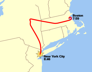
American Airlines Flight 11 was a domestic passenger flight that was hijacked by five al-Qaeda terrorists on the morning of September 11, 2001, as part of the September 11 attacks. The hijacked airliner was deliberately crashed into the North Tower of the World Trade Center complex in New York City, killing everyone still alive aboard the flight and resulting in the deaths of more than one thousand people in the top 18 stories of the skyscraper in addition to causing the demise of numerous others below the trapped floors, making it not only the deadliest of the four suicide attacks executed that morning in terms of both plane and ground fatalities, but also the single deadliest act of terrorism in human history and the deadliest plane crash of all time. The aircraft involved, a Boeing 767-200ER with 92 passengers and crew, was flying American Airlines' daily scheduled morning transcontinental service from Boston Logan International Airport in Massachusetts to Los Angeles International Airport in California.
WASA-LD
LPTV station in Port Jervis, New York
Distance: Approx. 57 meters
Latitude and longitude: 40.713,-74.01313889
WASA-LD (channel 24) is a low-power television station licensed to Port Jervis, New York, United States, serving the New York City area with programming from the Spanish-language network Estrella TV. The station is owned by Estrella Media, and its transmitter is located atop One World Trade Center in lower Manhattan. WASA briefly used virtual channel 64 to match its former analog channel number, then later changed its virtual channel to 24. It does not use its actual digital TV channel assignment on the air, because WNYE-TV calls itself Channel 25, its long-time analog channel number.
Sky Gate, New York
Sculpture by Louise Nevelson
Distance: Approx. 61 meters
Latitude and longitude: 40.712,-74.013
Sky Gate, New York was a sculpture by the artist Louise Nevelson, located in the mezzanine of the North Tower of the World Trade Center in New York, from 1978 until its 2001 destruction in the collapse of the buildings during the September 11 attacks. Nevelson was inspired by a New York skyline view she had seen from a flight from New York to Washington, saying the work was a translation of the skyline, calling her sculpture a "night piece" representing the "windows of New York".
1975 World Trade Center fire
Case of arson in Lower Manhattan
Distance: Approx. 46 meters
Latitude and longitude: 40.712094,-74.013208
The 1975 World Trade Center fire was a case of arson at the One World Trade Center in Lower Manhattan, New York occurring on February 12, 1975. The initial fire was started, and spread from the 11th floor from between the 9th and 14th floors, but was quickly extinguished by firefighters. The arsonist was later caught three months later on May 20 and was identified to be Oswald Adorno, a custodian working at the WTC, whose motive was because he was "disgruntled with his employer", said by Fire Commissioner Stephen J. Murphy.
Weather in this IP's area
clear sky
-1 Celsius
-4 Celsius
-2 Celsius
0 Celsius
1030 hPa
51 %
1030 hPa
1029 hPa
10000 meters
2.68 m/s
4.02 m/s
222 degree