209.137.131.186 - IP Lookup: Free IP Address Lookup, Postal Code Lookup, IP Location Lookup, IP ASN, Public IP
Country:
Region:
City:
Location:
Time Zone:
Postal Code:
IP information under different IP Channel
ip-api
Country
Region
City
ASN
Time Zone
ISP
Blacklist
Proxy
Latitude
Longitude
Postal
Route
Luminati
Country
Region
sc
City
greer
ASN
Time Zone
America/New_York
ISP
KDDIA-NET
Latitude
Longitude
Postal
IPinfo
Country
Region
City
ASN
Time Zone
ISP
Blacklist
Proxy
Latitude
Longitude
Postal
Route
IP2Location
209.137.131.186Country
Region
california
City
los angeles
Time Zone
America/Los_Angeles
ISP
Language
User-Agent
Latitude
Longitude
Postal
db-ip
Country
Region
City
ASN
Time Zone
ISP
Blacklist
Proxy
Latitude
Longitude
Postal
Route
ipdata
Country
Region
City
ASN
Time Zone
ISP
Blacklist
Proxy
Latitude
Longitude
Postal
Route
Popular places and events near this IP address

Denishawn school
Distance: Approx. 251 meters
Latitude and longitude: 34.0533,-118.261
The Denishawn School of Dancing and Related Arts, founded in 1915 by Ruth St. Denis and Ted Shawn in Los Angeles, California, helped many perfect their dancing talents and became the first dance academy in the United States to produce a professional dance company. Some of the school's more notable pupils include Martha Graham, Doris Humphrey, Lillian Powell, Charles Weidman, Jack Cole, and silent film star Louise Brooks.

Good Samaritan Hospital (Los Angeles)
Hospital in California, United States
Distance: Approx. 217 meters
Latitude and longitude: 34.05444444,-118.26527778
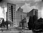
PIH Health Good Samaritan Hospital is a hospital in Los Angeles, California. The hospital has 408 beds. In 2019 Good Samaritan joined the PIH Health network.

1100 Wilshire
37-story residential and commercial skyscraper in Los Angeles, California
Distance: Approx. 90 meters
Latitude and longitude: 34.0522,-118.2638
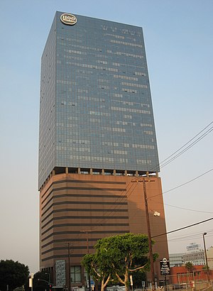
1100 Wilshire is a 37-story, 151.18 m (496.0 ft) residential and commercial skyscraper completed in 1987 in the Central City West neighborhood of Los Angeles. It is the 35th tallest building in the city, the 2nd tallest residential building in the entire Southern California region, and the 4th tallest residential building in the state of California. The 35,262 m2 (379,560 sq ft) tower was designed by AC Martin Partners.

ARCO Tower (Los Angeles)
Skyscraper in Los Angeles
Distance: Approx. 260 meters
Latitude and longitude: 34.0507,-118.2632
ARCO Tower (currently known as 1055 West Seventh) is a high-rise office building located at 1055 West Seventh Street in Los Angeles, California. It has 33 stories and stands at a height of 141 m (463 ft), making it the 32nd tallest building in Los Angeles. Located in Central City West, It has a prominent position in the local skyline, as it is across the 110 (Harbor) Freeway from the majority of the skyscrapers in downtown Los Angeles and the only other nearby building taller than it is 1100 Wilshire.

Figueroa at Wilshire
53-story skyscraper in Downtown Los Angeles, designed by Albert C. Martin & Associates.
Distance: Approx. 480 meters
Latitude and longitude: 34.0507,-118.2593
Figueroa at Wilshire, formerly Sanwa Bank Plaza, is a 53-story, 218.5 m (717 ft) skyscraper in Los Angeles, California, United States. It is the eighth-tallest building in Los Angeles. It was designed by Albert C. Martin & Associates, and developed by Hines Interests Limited Partnership.

Wilmington Branch
United States historic place
Distance: Approx. 433 meters
Latitude and longitude: 34.05361111,-118.26833333
Wilmington Branch is a branch library of the Los Angeles Public Library located in the Wilmington section of Los Angeles, California. It was built in 1927 based on a Spanish Colonial Revival design by architect W.E. McAllister. In 1987, the Wilmington Branch and several other branch libraries in Los Angeles were added to the National Register of Historic Places as part of a thematic group submission.
Los Angeles Center Studios
Building in Los Angeles, California
Distance: Approx. 359 meters
Latitude and longitude: 34.055393,-118.26109
Los Angeles Center Studios, is a 20-acre film production studio located in the City West neighborhood of Los Angeles, California, United States.

Global Cinematography Institute
Distance: Approx. 361 meters
Latitude and longitude: 34.0546,-118.2603
Global Cinematography Institute (GCI) is a film school that teaches new emerging technologies and concepts in the field of cinematography. Founded by Yuri Neyman, ASC and Vilmos Zsigmond, ASC, the Global Cinematography Institute aims to prepare filmmakers to take advantage of on-going advances in digital and virtual cinematography technologies through a curriculum known as Expanded Cinematography. In 2021, GCI announced that they were deferring all sessions and stopped taking student applications, due to the COVID-19 pandemic.
Quality Cafe (diner)
Distance: Approx. 310 meters
Latitude and longitude: 34.052057,-118.266857
The Quality Cafe (also known as Quality Diner) was a diner at 1236 West 7th Street in Los Angeles, California. The restaurant ceased to function as a diner in late 2006 but has appeared as a location featured in a number of Hollywood films, including Million Dollar Baby, Training Day, Old School, Se7en, Ghost World, Gone in 60 Seconds, The Stepfather, What's Love Got to Do with It, Sex and Death 101, and Catch Me If You Can. It was also featured in Season 1 of the 2007 television series Mad Men, in the episode "5G".
Studio School Los Angeles
School in California, United States
Distance: Approx. 347 meters
Latitude and longitude: 34.0545,-118.2604
Studio School Los Angeles was a performing arts and film school located in downtown Los Angeles. The school was founded in 2013 by Glenn Kalison, American actor, producer and entrepreneur, as Relativity School with the former film studio, Relativity Media. The name was changed to Studio School in 2017 following Relativity Media's bankruptcy.

The Beaudry
Residential in Los Angeles, California
Distance: Approx. 470 meters
Latitude and longitude: 34.049067,-118.261843
The Beaudry is a residential tower in downtown Los Angeles, California that is located within FIGat7th shopping mall. It was developed by Brookfield Properties and designed by architects Marmol Radziner and LARGE Architecture. The tower is named after former 19th century Los Angeles mayor, Prudent Beaudry.

Mayfair Hotel (Los Angeles)
Historic hotel in Los Angeles, California
Distance: Approx. 374 meters
Latitude and longitude: 34.05217868,-118.26763283
The Mayfair Hotel is a historic hotel in the Westlake neighborhood of Los Angeles, California. The Sun Realty Company commissioned the building in 1926 and architectural firm Curlett & Beelman designed it in the Renaissance Revival style. The hotel opened on February 1, 1927.
Weather in this IP's area
smoke
21 Celsius
20 Celsius
19 Celsius
22 Celsius
1013 hPa
29 %
1013 hPa
1000 hPa
10000 meters
6.17 m/s
11.83 m/s
20 degree