Country:
 USA
USARegion:
City:
Latitude and Longitude:
Time Zone:
Postal Code:
IP information under different IP Channel
ip-api
Country
Region
City
ASN
Time Zone
ISP
Blacklist
Proxy
Latitude
Longitude
Postal
Route
IPinfo
Country
Region
City
ASN
Time Zone
ISP
Blacklist
Proxy
Latitude
Longitude
Postal
Route
MaxMind
Country
Region
City
ASN
Time Zone
ISP
Blacklist
Proxy
Latitude
Longitude
Postal
Route
Luminati
Country
USASN
Time Zone
America/Chicago
ISP
DREAMHOST-AS
Latitude
Longitude
Postal
db-ip
Country
Region
City
ASN
Time Zone
ISP
Blacklist
Proxy
Latitude
Longitude
Postal
Route
ipdata
Country
Region
City
ASN
Time Zone
ISP
Blacklist
Proxy
Latitude
Longitude
Postal
Route
Popular places and events near this IP address

Brea, California
City in California, United States
Distance: Approx. 1264 meters
Latitude and longitude: 33.92333333,-117.88888889
Brea (; Spanish for 'tar') is a city in northern Orange County, California. The population as of the 2010 census was 39,282. It is 33 miles (53 km) southeast of Los Angeles.

Brea Mall
Shopping mall in California, United States
Distance: Approx. 1276 meters
Latitude and longitude: 33.91548,-117.88627
The Brea Mall is an enclosed shopping mall located in the Orange County city of Brea, California. Since 1998, the mall has been owned and operated by the Simon Property Group. It is home to four major department stores, 179 specialty shops and boutiques, and a food court.

Brea Olinda High School
Public 4-year school in Brea, California, United States
Distance: Approx. 2887 meters
Latitude and longitude: 33.933244,-117.875925
Brea Olinda High School is a 9th–12th grade public high school located in Brea, California. Established in 1927, the school was originally located across the street from the Brea Mall. In 1989, the school moved to its current location on the northern hills of Brea.
California's 40th congressional district
U.S. House district for California
Distance: Approx. 3245 meters
Latitude and longitude: 33.894642,-117.922955
California's 40th congressional district is a congressional district in the U.S. state of California, encompassing Orange, San Bernardino, and Riverside counties. The district is currently represented by Republican Young Kim. It was one of 18 districts that would have voted for Joe Biden in the 2020 presidential election had they existed in their current configuration while being won or held by a Republican in 2022.

Titan Stadium (Cal State Fullerton)
Multi-purpose stadium at Cal State Fullerton
Distance: Approx. 3555 meters
Latitude and longitude: 33.886646,-117.886992
Titan Stadium is a 10,000-capacity multi-purpose stadium on the campus of California State University, Fullerton in Fullerton, California.

Brea-Olinda Unified School District
School district in California
Distance: Approx. 1025 meters
Latitude and longitude: 33.917163,-117.888913
Brea Olinda Unified School District is the school district serving the City of Brea in Orange County, California, United States. It also serves portions of the nearby cities of Fullerton, Yorba Linda and La Habra.
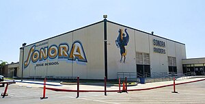
Sonora High School (La Habra, California)
Public secondary school in La Habra, California, USA
Distance: Approx. 2649 meters
Latitude and longitude: 33.9275,-117.92555556
Sonora High School (SOHS) is a public high school located at 401 S. Palm Street in La Habra, north Orange County, California. One of seven high schools in the Fullerton Joint Union High School District, Sonora served over 1,944 students in the 2012-2013 school year. The school has an International Baccalaureate program, honors, and Advanced Placement (AP) options available for certain classes and is accredited by the Western Association of Schools and Colleges (WASC).
St. Jude Medical Center
Hospital in California, United States
Distance: Approx. 3509 meters
Latitude and longitude: 33.89472222,-117.92722222
St. Jude Medical Center is a faith-based, not-for-profit hospital, located in Fullerton, California, which was established by the Sisters of St. Joseph of Orange in 1957.
Marshall B. Ketchum University
Private university in Fullerton, California, US
Distance: Approx. 3296 meters
Latitude and longitude: 33.8894478,-117.88606612
Marshall B. Ketchum University is a private university focused on graduate programs in healthcare and located in Fullerton, California. MBKU expanded from the Southern California College of Optometry which was founded in 1904. The university was officially established as a multidisciplinary university with the addition of School of PA Studies in 2011 and College of Pharmacy in 2013.

Brea City Hall and Park
Historic place in California, United States
Distance: Approx. 310 meters
Latitude and longitude: 33.91416667,-117.90138889
Brea City Hall Park, in Brea, California, was listed on the National Register of Historic Places in 1984. The Brea City Hall, designed by architect Allen Ruott, is combination of Art Deco and Spanish Colonial Revival in styling and was built in 1928. It included a public library as well as the site for the Brea Police Department and jail.
East Coyote Hills
Californian mountain range
Distance: Approx. 2730 meters
Latitude and longitude: 33.89223639,-117.90200444
The East Coyote Hills are a low mountain range in northern Orange County, California, mostly in the cities of Fullerton and Placentia. The hills received their name from the nearby Rancho Los Coyotes; by the 1870s they were being called Coyote Hills. Most of the East Coyote Hills were developed as residential areas in the 1980s and 1990s.

2014 La Habra earthquake
Earthquake in California, U.S.
Distance: Approx. 2340 meters
Latitude and longitude: 33.933,-117.916
The 2014 La Habra earthquake was a magnitude 5.1 earthquake that occurred on March 28, 2014, at 9:09:42 p.m. PDT. Although given the name "La Habra" it was centered in Brea, a city in northern Orange County. Despite its moderate magnitude, it had a maximum Mercalli intensity of VII (Very strong), and caused a total of $10.8 million in damage.
Weather in this IP's area
clear sky
26 Celsius
26 Celsius
23 Celsius
29 Celsius
1016 hPa
35 %
1016 hPa
1004 hPa
10000 meters
5.14 m/s
220 degree
07:00:08
18:12:27