Country:
 Australia
Region:
City:
Latitude and Longitude:
Time Zone:
Postal Code:
IP information under different IP Channel
ip-api
Country
Region
City
ASN
Time Zone
ISP
Blacklist
Proxy
Latitude
Longitude
Postal
Route
IPinfo
Country
Region
City
ASN
Time Zone
ISP
Blacklist
Proxy
Latitude
Longitude
Postal
Route
MaxMind
Country
Region
City
ASN
Time Zone
ISP
Blacklist
Proxy
Latitude
Longitude
Postal
Route
Luminati
Country
 US
USASN
Time Zone
America/Chicago
ISP
TIGGEE
Latitude
Longitude
Postal
db-ip
Country
Region
City
ASN
Time Zone
ISP
Blacklist
Proxy
Latitude
Longitude
Postal
Route
ipdata
Country
Region
City
ASN
Time Zone
ISP
Blacklist
Proxy
Latitude
Longitude
Postal
Route
Popular places and events near this IP address
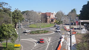
Sutherland, New South Wales
Suburb of Sydney, New South Wales, Australia
Distance: Approx. 377 meters
Latitude and longitude: -34.03314,151.0583
Sutherland is a suburb in southern Sydney, in the state of New South Wales, Australia. Sutherland is located 26 kilometres south of the Sydney central business district and is the administrative centre for the local government area of the Sutherland Shire.

Sutherland Shire
Local government area in New South Wales, Australia
Distance: Approx. 1059 meters
Latitude and longitude: -34.03333333,151.05
Sutherland Shire is a local government area (LGA) in the southern region of Sydney, in the state of New South Wales, Australia. Sutherland Shire is located approximately 26 kilometres south-southwest of the Sydney central business district, and comprises an area of 370 square kilometres (140 sq mi). As at the 2016 census, Sutherland Shire has an estimated population of 218,464.

Jannali
Suburb of Sydney, New South Wales, Australia
Distance: Approx. 1569 meters
Latitude and longitude: -34.01695,151.06522
Jannali is a suburb in southern Sydney, in the state of New South Wales, Australia. Jannali is located 28 kilometres south of the Sydney central business district in the local government area of the Sutherland Shire. The majority of land use in Jannali is residential and bushland reserve, while the suburb is bisected by the north–south railway line.

Jannali railway station
Railway station in Sydney, New South Wales, Australia
Distance: Approx. 1658 meters
Latitude and longitude: -34.016,151.06458
Jannali railway station is a partially heritage-listed railway station located on the Illawarra line, serving the Sydney suburb of Jannali. It is served by Sydney Trains' T4 Eastern Suburbs & Illawarra Line services.

Kirrawee railway station
Railway station in Sydney, New South Wales, Australia
Distance: Approx. 1058 meters
Latitude and longitude: -34.03498334,151.071175
Kirrawee railway station is located on the Cronulla line, serving the Sydney suburb of Kirrawee. It is served by Sydney Trains' T4 Eastern Suburbs & Illawarra Line services.

Woronora
Suburb of Sydney, New South Wales, Australia
Distance: Approx. 1650 meters
Latitude and longitude: -34.026,151.044
Woronora is a suburb in southern Sydney, in the state of New South Wales, Australia. Woronora is located 27 kilometres south of the Sydney central business district, in the local government area of the Sutherland Shire. Woronora Heights is a separate suburb, to the south-west.

Kirrawee, New South Wales
Suburb of Sydney, New South Wales, Australia
Distance: Approx. 1040 meters
Latitude and longitude: -34.03472222,151.07111111
Kirrawee is a suburb in southern Sydney, in the state of New South Wales, Australia. Kirrawee is located 25 kilometres south of the Sydney central business district in the Sutherland Shire. Kirrawee lies between Sutherland, to the west, and Gymea and Grays Point, to the east.

Sutherland railway station
Railway station in Sydney, New South Wales, Australia
Distance: Approx. 363 meters
Latitude and longitude: -34.03175,151.05732
Sutherland railway station is a heritage-listed railway station located on the Illawarra line, serving the Sydney suburb of Sutherland. It is served by Sydney Trains' T4 Eastern Suburbs & Illawarra Line services and NSW TrainLink's South Coast Line services.

St Patrick's College, Sutherland
School in Australia
Distance: Approx. 299 meters
Latitude and longitude: -34.033287,151.061142
St Patrick's College is an independent Roman Catholic co-educational secondary day school, located in Sutherland, Southern Sydney, New South Wales, Australia. The college provides a general and religious education for students from Year 7 to Year 12. The school traces its founding to Christian Brothers College, established as an upper primary school in 1956 by the Congregation of Christian Brothers.

Horizon Church
Church in Australia
Distance: Approx. 55 meters
Latitude and longitude: -34.0306,151.0604
Horizon Church, founded as Sutherland AOG, and formerly more recently Shirelive, is a Pentecostal Christian church affiliated with Australian Christian Churches, the Australian branch of the Assemblies of God denomination. The church's main campus is in the commercial district of Sutherland, a southern suburb of Sydney, New South Wales. The church's senior pastors are Brad and Alison Bonhomme, and the former Prime Minister of Australia, Scott Morrison, is a member of the congregation.
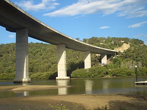
Woronora River Bridge
Bridge in New South Wales, Australia
Distance: Approx. 1661 meters
Latitude and longitude: -34.0194,151.0491
The Woronora River Bridge, also known as Woronora Bridge, is a four-lane road bridge that carries River Road across the Woronora River at Woronora, in Southern Sydney, New South Wales, Australia. The bridge, at the time of its completion in 2001, was the largest incrementally launched bridge in the Southern Hemisphere with horizontal and vertical curves.
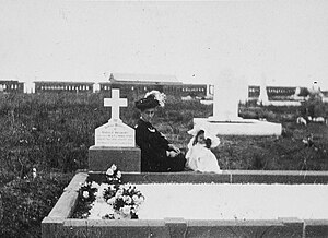
Woronora Cemetery railway station
Former railway station in New South Wales, Australia
Distance: Approx. 1121 meters
Latitude and longitude: -34.0322,151.049
Woronora Cemetery railway station was a funerary railway station on the Illawarra railway line in New South Wales, Australia. The station served the Woronora Memorial Park. The station opened months after the first burial in 1900, and closed in 1947 due to the rising popularity in funeral motor cars.
Weather in this IP's area
broken clouds
18 Celsius
18 Celsius
17 Celsius
18 Celsius
1016 hPa
89 %
1016 hPa
1004 hPa
10000 meters
2.57 m/s
210 degree
75 %
06:09:10
19:11:58