Country:
 USA
USARegion:
City:
Latitude and Longitude:
Time Zone:
Postal Code:
IP information under different IP Channel
ip-api
Country
Region
City
ASN
Time Zone
ISP
Blacklist
Proxy
Latitude
Longitude
Postal
Route
IPinfo
Country
Region
City
ASN
Time Zone
ISP
Blacklist
Proxy
Latitude
Longitude
Postal
Route
MaxMind
Country
Region
City
ASN
Time Zone
ISP
Blacklist
Proxy
Latitude
Longitude
Postal
Route
Luminati
Country
USASN
Time Zone
America/Chicago
ISP
AS-NSI-GLOBAL
Latitude
Longitude
Postal
db-ip
Country
Region
City
ASN
Time Zone
ISP
Blacklist
Proxy
Latitude
Longitude
Postal
Route
ipdata
Country
Region
City
ASN
Time Zone
ISP
Blacklist
Proxy
Latitude
Longitude
Postal
Route
Popular places and events near this IP address

Jefferson Park, Chicago
Community area in Chicago
Distance: Approx. 510 meters
Latitude and longitude: 41.98,-87.77
Jefferson Park is one of the 77 community areas of Chicago, located on the northwest side of the city. The neighborhood of Jefferson Park occupies a larger swath of territory. Jefferson Park is bordered by the community areas of Norwood Park to the northwest, Forest Glen to the northeast, Portage Park to the south, and the suburb of Harwood Heights to the west.
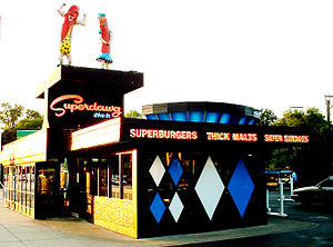
Superdawg
Restaurant in Illinois, United States
Distance: Approx. 1886 meters
Latitude and longitude: 41.996763,-87.78706
Superdawg is a drive-in hot dog stand with carhop service. It is located in the Norwood Park neighborhood of Chicago, at the intersection of Milwaukee, Devon, and Nagle Avenues. Superdawg has the distinction of being one of the few original drive-in restaurants left in the United States.
William Howard Taft High School (Chicago)
Chicago high school
Distance: Approx. 1389 meters
Latitude and longitude: 41.9844,-87.79192
Taft High School is a public four-year high school located in the Norwood Park neighborhood on the northwest side of Chicago, Illinois, United States. Taft serves communities on the far northwest side, specifically Norwood Park, Edison Park, Jefferson Park, Forest Glen and O'Hare. Taft is operated by the Chicago Public Schools district.
WSBC
Radio station in Illinois, United States
Distance: Approx. 272 meters
Latitude and longitude: 41.98141944,-87.77228333
WSBC (1240 kHz) is a commercial AM radio station in Chicago, Illinois. It broadcasts brokered programming, mostly ethnic and religious. It is owned by Hearland Signal LLC. WSBC transmits with 1,000 watts.

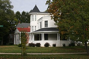
Noble–Seymour–Crippen House
Historic house in Illinois, United States
Distance: Approx. 1710 meters
Latitude and longitude: 41.98361111,-87.79597222
The Noble–Seymour–Crippen House is a mansion located at 5624 North Newark Avenue in Chicago's Norwood Park community area. Its southern wing, built in 1833, is widely considered the oldest existing building in Chicago.
Old Edgebrook District
Neighborhood in Forest Glen, United States
Distance: Approx. 1540 meters
Latitude and longitude: 41.995,-87.76833333
Old Edgebrook is a historic district and neighborhood in the Forest Glen community area of Chicago, Illinois, United States. It is located between Central and Devon Avenues and the Edgebrook Golf Course. It is surrounded on all sides by Cook County Forest Preserves.

Gladstone Park station
Railway station in the United States of America
Distance: Approx. 338 meters
Latitude and longitude: 41.9798,-87.7779
Gladstone Park is a station on Metra's Union Pacific Northwest Line located in the Gladstone Park neighborhood of Chicago, Illinois. Gladstone Park primarily serves rush hour trains and is closed on weekends and holidays. The station is located at 5500 N. Austin Avenue, adjacent to the Kennedy Expressway.
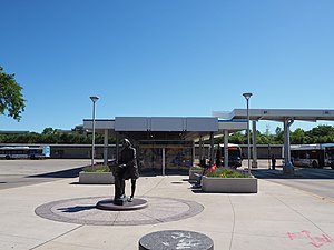
Jefferson Park Transit Center
Transport hub in Chicago, Illinois
Distance: Approx. 1731 meters
Latitude and longitude: 41.970766,-87.761232
The Jefferson Park Transit Center is an intermodal passenger transport hub in the Jefferson Park neighborhood of Chicago, Illinois. It serves as a station for rail and also as a bus terminal. Jefferson Park Transit Center's railroad station is on Metra's Union Pacific Northwest Line, with the station located at 4963 North Milwaukee Avenue.

Forest Glen station (Illinois)
Commuter rail station in Chicago, Illinois
Distance: Approx. 1701 meters
Latitude and longitude: 41.9781,-87.7556
Forest Glen is one of two Metra commuter railroad stations in the Forest Glen section of Chicago, Illinois, along the Milwaukee District North Line. It is located at 5301 North Forest Glen Avenue, is 10.2 miles (16.4 km) away from Chicago Union Station, the southern terminus of the line, and serves commuters between Union Station and Fox Lake, Illinois. In Metra's zone-based fare system, Forest Glen is in zone 2.

Jefferson Park (Chicago park)
United States historic place
Distance: Approx. 1826 meters
Latitude and longitude: 41.96833333,-87.76361111
Jefferson Park is a 7-acre (2.8 ha) park in the Jefferson Park community area of Chicago, Illinois on the National Register of Historic Places.
R.S. Owens & Company
Distance: Approx. 1286 meters
Latitude and longitude: 41.981525,-87.75988056
R.S. Owens is an awards design and manufacturing company based in Chicago, Illinois, and has been in business since 1938. The company describes itself as the "world's largest manufacturer of premier awards". The company manufactures and designs custom trophies for a worldwide market.

Jefferson Masonic Temple
Distance: Approx. 1498 meters
Latitude and longitude: 41.970561,-87.766304
Jefferson Masonic Temple is a building completed in 1913 in Jefferson Park, it provides a meeting space for Masonic Lodges and appendant bodies in the 5th Northeastern District of the Grand Lodge Of Illinois: Oriental Lodge #33, Hesperia #411, King Oscar Lodge #855, Paul Revere Lodge #998, and Kelvyn Park-Willing Lodge #1075. In 1913, the Wiley M. Providence Lodge formed the Jefferson Masonic Association and built their new temple. Jefferson Masonic Association now maintains the Jefferson Masonic Temple.
Weather in this IP's area
scattered clouds
9 Celsius
8 Celsius
6 Celsius
10 Celsius
1022 hPa
82 %
1022 hPa
999 hPa
10000 meters
2.06 m/s
260 degree
40 %
06:24:37
19:12:57