Country:
Region:
City:
Latitude and Longitude:
Time Zone:
Postal Code:
IP information under different IP Channel
ip-api
Country
Region
City
ASN
Time Zone
ISP
Blacklist
Proxy
Latitude
Longitude
Postal
Route
Luminati
Country
ASN
Time Zone
America/Chicago
ISP
IMMEDION
Latitude
Longitude
Postal
IPinfo
Country
Region
City
ASN
Time Zone
ISP
Blacklist
Proxy
Latitude
Longitude
Postal
Route
db-ip
Country
Region
City
ASN
Time Zone
ISP
Blacklist
Proxy
Latitude
Longitude
Postal
Route
ipdata
Country
Region
City
ASN
Time Zone
ISP
Blacklist
Proxy
Latitude
Longitude
Postal
Route
Popular places and events near this IP address

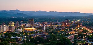
Asheville, North Carolina
City in the United States
Distance: Approx. 65 meters
Latitude and longitude: 35.59555556,-82.55194444
Asheville ( ASH-vil) is a city in and the county seat of Buncombe County, North Carolina, United States. Located at the confluence of the French Broad and Swannanoa rivers, it is the most populous city in Western North Carolina, and the state's 11th-most-populous city. According to the 2020 census, the city's population was 94,589, up from 83,393 in the 2010 census.

Asheville Art Museum
Distance: Approx. 90 meters
Latitude and longitude: 35.5944,-82.551
The Asheville Art Museum is a nonprofit visual art organization in Western North Carolina (WNC) and is accredited by the American Alliance of Museums. The museum is located on the center square of downtown Asheville, 2 South Pack Square at Pack Place. The Asheville Art Museum presents exhibitions and public programs based on its permanent collection of 20th and 21st century American art.
Jackson Building (Asheville, North Carolina)
Building in North Carolina, United States
Distance: Approx. 93 meters
Latitude and longitude: 35.5949,-82.5505
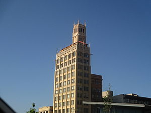
The Jackson Building is a 140 ft (43m) 15-story building in downtown Asheville, North Carolina, which was completed in 1924 in Pack Square. It was the first skyscraper in western North Carolina.

Asheville Female College
Distance: Approx. 189 meters
Latitude and longitude: 35.5946,-82.5535
The Asheville Female College was the first institution of higher education in the western portion of North Carolina, founded as the Asheville Female Seminary in 1841 by John Dickson, M.D. and Rev. Erastus Rowley, D.D. The school had its first quarters on the corner of Patton Avenue and Church Street in Asheville, North Carolina. Between 1851 and 1855 the school became the property of the Holston Conference of the Methodist Church and its name was changed to the Holston Conference Female College.

S & W Cafeteria (Asheville, North Carolina)
United States historic place
Distance: Approx. 228 meters
Latitude and longitude: 35.59444444,-82.55388889
S & W Cafeteria is a historic S & W Cafeteria building located in the Downtown Asheville Historic District of Asheville, Buncombe County, North Carolina, USA. It was designed by the architect Douglas Ellington and built in 1929. It is a three-story, brick building in the Art Deco style. The front facade is sheathed in grey ashlar and features polychrome ornamentation and exotic stylistic motifs.

Young Men's Institute Building
United States historic place
Distance: Approx. 174 meters
Latitude and longitude: 35.59388889,-82.55027778
Young Men's Institute Building, also known as the YMI Building, is a historic meeting hall located at Asheville, Buncombe County, North Carolina. It was designed by architect Richard Sharp Smith and built in 1892–1893. It is a 2+1⁄2-story, pebbledash coated masonry building with brick, stone, and wood accents.
Downtown Asheville Historic District
Historic district in North Carolina, United States
Distance: Approx. 166 meters
Latitude and longitude: 35.595,-82.55333333
Downtown Asheville Historic District is a national historic district located at Asheville, Buncombe County, North Carolina. The district encompasses about 279 contributing buildings and one contributing object in the central business district of Asheville. It includes commercial, institutional, and residential buildings in a variety of popular architectural styles including Colonial Revival, Queen Anne, and Art Deco.

The Arras
Tallest building in Asheville, North Carolina. Built in 1965
Distance: Approx. 65 meters
Latitude and longitude: 35.59518,-82.55221
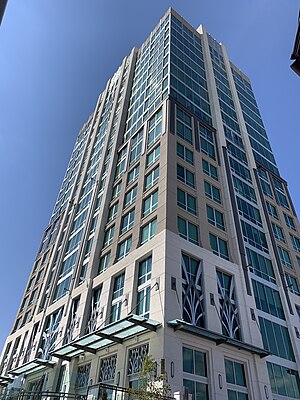
The Arras is the tallest building in Asheville, North Carolina with 19 stories and 201,000 square feet. It was built in 1965 as the Northwestern Bank Building and was later called the BB&T Building. In 2019, it reopened as the Art Deco style Kimpton Hotel Arras on floors 1 to 9, and Arras Private Residences condominium complex on floors 10-19 after a major renovation.
Wortham Center for the Performing Arts
Distance: Approx. 91 meters
Latitude and longitude: 35.59434,-82.55112
The Wortham Center for the Performing Arts, formerly known as the Diana Wortham Theatre, is a 28,000 square foot (2,600 m2) theater in Pack Place in Asheville, North Carolina. The main 500-seat Proscenium theater opened July 4, 1992 has about 50 shows each season between September and May, plus more than 100 events presented by groups that rent the space.
Vance Monument
Landmark in Asheville, North Carolina (1898–2021)
Distance: Approx. 3 meters
Latitude and longitude: 35.59508333,-82.55147222
The Vance Monument was a late 19th-century granite obelisk in Asheville, North Carolina, that memorialized Zebulon Vance, a former North Carolina governor from the area. The monument was designed by architect Richard Sharp Smith and was an "iconic landmark" and key structure in the Downtown Asheville Historic District. Smith was the supervising architect for George W. Vanderbilt's Biltmore Estate and the leading architect of the region in the late 19th and early 20th centuries.

Hayes and Hopson Building
Building in Asheville, North Carolina, United States
Distance: Approx. 172 meters
Latitude and longitude: 35.5951,-82.5496
The Hayes and Hopson Building (originally the Westall Building) is a historic three-story structure on South Spruce Street in Asheville, North Carolina. Built in 1907 and expanded in 1912, the building overlooks Pack Square Park. It became an important meeting point during Prohibition, when liquor was exchanged beneath the building via a network of tunnels.

Pack Square Park
Public square in Asheville, North Carolina
Distance: Approx. 204 meters
Latitude and longitude: 35.5955,-82.5493
Pack Square Park is a public square in Asheville, North Carolina. Situated immediately west of Asheville City Hall and Buncombe County Courthouse and established in 1903, it is bounded by South Spruce Street to the west, College Street to the north, Court Plaza to the east, and Marjorie Street to the south. In 2009, a memorial to Western North Carolina Veterans was installed on the northern side of the square, while a covered stage occupies the eastern side.
Weather in this IP's area
overcast clouds
9 Celsius
7 Celsius
6 Celsius
10 Celsius
1016 hPa
83 %
1016 hPa
938 hPa
10000 meters
4.12 m/s
8.75 m/s
350 degree
100 %
07:06:30
17:23:32

