Country:
Region:
City:
Latitude and Longitude:
Time Zone:
Postal Code:
IP information under different IP Channel
ip-api
Country
Region
City
ASN
Time Zone
ISP
Blacklist
Proxy
Latitude
Longitude
Postal
Route
Luminati
Country
ASN
Time Zone
America/Chicago
ISP
IMMEDION
Latitude
Longitude
Postal
IPinfo
Country
Region
City
ASN
Time Zone
ISP
Blacklist
Proxy
Latitude
Longitude
Postal
Route
db-ip
Country
Region
City
ASN
Time Zone
ISP
Blacklist
Proxy
Latitude
Longitude
Postal
Route
ipdata
Country
Region
City
ASN
Time Zone
ISP
Blacklist
Proxy
Latitude
Longitude
Postal
Route
Popular places and events near this IP address

Fruitdale, San Jose
Place in California, United States
Distance: Approx. 2224 meters
Latitude and longitude: 37.31277778,-121.93583333
Fruitdale is a district of San Jose, California, though some portions are still unincorporated as a census-designated place. The population of the CDP was 935 at the 2010 census.

Burbank, Santa Clara County, California
Place in California, United States
Distance: Approx. 1937 meters
Latitude and longitude: 37.32055556,-121.93166667
Burbank is a unincorporated community in Santa Clara County, California. As an urban Island, it is surrounded by the city of San Jose. The population was 4,926 at the 2010 census.

Winchester Mystery House
Mansion in San Jose, California
Distance: Approx. 1151 meters
Latitude and longitude: 37.31836111,-121.95076111
The Winchester Mystery House is a mansion in San Jose, California, that was once the personal residence of Sarah Winchester, the widow of firearms magnate William Wirt Winchester. The house became a tourist attraction nine months after Winchester's death in 1922. The Victorian and Gothic-style mansion is renowned for its size and its architectural curiosities and for the numerous myths and legends surrounding the structure and its former owner.

Harker School
Independent school in San Jose, California, United States
Distance: Approx. 2195 meters
Latitude and longitude: 37.3176,-121.9715
The Harker School is a private, co-educational school located in San Jose, California. Founded in 1893 as Manzanita Hall, Harker now has three campuses: Bucknall, Union, and Saratoga, named after the streets on which they lie. The Bucknall campus houses the Lower School (kindergarten through grade 5), the Union campus houses the Middle School (grades 6–8), and the Saratoga campus houses the Upper School (grades 9 through 12).

Santana Row
Neighborhood of San Jose in Santa Clara County, California, United States
Distance: Approx. 980 meters
Latitude and longitude: 37.32027778,-121.94777778
Santana Row (abbreviated as SR or The Row) is an upscale residential and commercial district of West San Jose in San Jose, California. Santana Row is intersected by Stevens Creek Boulevard, a major thoroughfare, and close to local landmarks like Westfield Valley Fair and the Winchester Mystery House.
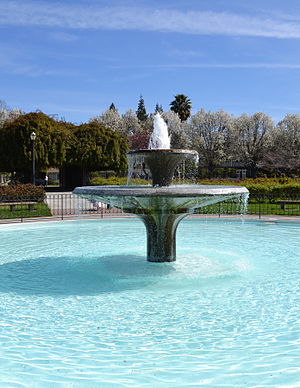
San Jose Municipal Rose Garden
Historic American rose garden in San Jose, California
Distance: Approx. 2013 meters
Latitude and longitude: 37.33176,-121.92859
The San Jose Municipal Rose Garden is a historic rose garden in San Jose, California, in the Rose Garden District. Founded in 1927, the garden is exclusively dedicated to roses and features more than 3,500 shrubs representing 189 rose varieties. The AARS named the SJ Municipal Rose Garden as "America's Best Rose Garden", making it the winner in the first nationwide competition ever.

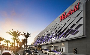
Westfield Valley Fair
Shopping mall in California, U.S.
Distance: Approx. 852 meters
Latitude and longitude: 37.325095,-121.942508
Westfield Valley Fair, commonly known as Valley Fair, is a prominent shopping mall in Santa Clara, California. Valley Fair is the largest mall, by area, in Northern California and has higher sales revenue than all other malls in California, including the two in Southern California which have larger area than Valley Fair. Valley Fair is the fourteenth largest shopping mall in the United States.

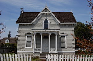
Andrew J. Landrum House
Historic house in California, United States
Distance: Approx. 2008 meters
Latitude and longitude: 37.34625,-121.945775
The Andrew J. Landrum House in Santa Clara, California, was built by Andrew J. Landrum, a prominent Santa Clara pioneer. Constructed in 1875, the house is an example of eclecticism in architectural styles. Landrum combined the then-popular Italianate and Carpenter Gothic styles he found in pattern books, as seen in the corner quoins, the Italianate porch with scroll brackets, gables with cross-bracing and the cruciform interior plan.
O'Connor Hospital
Hospital in California, United States
Distance: Approx. 1110 meters
Latitude and longitude: 37.3279,-121.9385
O'Connor Hospital is a hospital in San Jose, California, part of the Santa Clara County Health System. Located in the West San Carlos neighborhood of San Jose, O'Connor Hospital is one of the oldest hospitals in Santa Clara County, founded in 1889.
Le Papillon (restaurant)
Restaurant in California, United States
Distance: Approx. 2150 meters
Latitude and longitude: 37.31972222,-121.9725
Le Papillon (the French word for butterfly, pronounced [lə papiˈjɔ̃]) is a French restaurant located in San Jose, California. Le Papillon is located on a busy street corner between a hotel and a strip mall. Although the surrounding area is prosaic, the restaurant is "elegant (and expensive)".
Oratory of Our Mother of Perpetual Help
Church in California, USA
Distance: Approx. 2122 meters
Latitude and longitude: 37.347554,-121.947429
The Oratory of Our Mother of Perpetual Help is a traditional Catholic chapel operating independently of the Diocese of San Jose.
Wilson High School (California)
Alternative high school in Santa Clara, Santa Clara County, California, United States
Distance: Approx. 2023 meters
Latitude and longitude: 37.3463,-121.9567
Wilson High School is an alternative public high school in Santa Clara, California, United States. It is one of five high schools in the Santa Clara Unified School District (SCUSD) and is accredited by the Western Association of Schools and Colleges (WASC).
Weather in this IP's area
light rain
9 Celsius
8 Celsius
7 Celsius
11 Celsius
1013 hPa
80 %
1013 hPa
1009 hPa
10000 meters
2.06 m/s
270 degree
06:47:50
16:57:26
