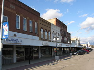
Country:
Region:
City:
Latitude and Longitude:
Time Zone:
Postal Code:
IP information under different IP Channel
ip-api
Country
Region
City
ASN
Time Zone
ISP
Blacklist
Proxy
Latitude
Longitude
Postal
Route
Luminati
Country
Region
ia
City
humboldt
ASN
Time Zone
America/Chicago
ISP
GLDFLDACCESS
Latitude
Longitude
Postal
IPinfo
Country
Region
City
ASN
Time Zone
ISP
Blacklist
Proxy
Latitude
Longitude
Postal
Route
db-ip
Country
Region
City
ASN
Time Zone
ISP
Blacklist
Proxy
Latitude
Longitude
Postal
Route
ipdata
Country
Region
City
ASN
Time Zone
ISP
Blacklist
Proxy
Latitude
Longitude
Postal
Route
Popular places and events near this IP address

Dakota City, Iowa
City in Iowa, United States
Distance: Approx. 1275 meters
Latitude and longitude: 42.72194444,-94.20027778
Dakota City is a city in and the county seat of Humboldt County, Iowa, United States. The population was 759 at the time of the 2020 census. Dakota City shares its western border with the much larger city of Humboldt.

Humboldt, Iowa
City in Iowa, United States
Distance: Approx. 775 meters
Latitude and longitude: 42.72361111,-94.22138889
Humboldt is a city in Humboldt County, Iowa, United States. The population was 4,792 at the time of the 2020 census, gaining 102 people over the 2010 total.

Humboldt High School (Iowa)
Public secondary school in Humboldt, Iowa, United States
Distance: Approx. 1245 meters
Latitude and longitude: 42.716111,-94.23
Humboldt High School is a public, co-educational high school in Humboldt, Iowa. It is a part of Humboldt Community School District, and serves grades nine through twelve. As the sole high school in its district, it serves Humboldt, Dakota City, Hardy, Renwick, and Rutland.
KHBT
Radio station in Humboldt, Iowa
Distance: Approx. 1724 meters
Latitude and longitude: 42.7325,-94.20638889
KHBT (97.7 FM) is an American commercial radio station that serves the Humboldt, Iowa, area. The station broadcasts an Classic Hits format. KHBT is licensed to Open Roads Media, L.L.C., of Humboldt, Iowa.

Berkhimer Bridge
United States historic place
Distance: Approx. 3870 meters
Latitude and longitude: 42.73916667,-94.25305556
Berkhimer Bridge is a high truss bridge built in 1899 located near Humboldt, Iowa. It spans the Des Moines River for 253.0 feet (77.1 m).

Humboldt County Courthouse (Iowa)
United States historic place
Distance: Approx. 464 meters
Latitude and longitude: 42.7225,-94.21611111
The Humboldt County Courthouse is located in Dakota City, Iowa, United States, and dates from 1939. It was listed on the National Register of Historic Places in 2003 as a part of the PWA-Era County Courthouses of IA Multiple Properties Submission. The courthouse is the second building the county has used for court functions and county administration.

Corydon Brown House
Historic house in Iowa, United States
Distance: Approx. 2096 meters
Latitude and longitude: 42.72444444,-94.19083333
The Corydon Brown House is a house in Dakota City, Iowa, United States. It was listed on the National Register of Historic Places on November 14, 1978. Corydon Brown, the former owner of the house, was a miller, and the house was a social hub for many years.
Des Moines River Bridge (Humboldt, Iowa)
United States historic place
Distance: Approx. 3802 meters
Latitude and longitude: 42.73194444,-94.25777778
The Des Moines River Bridge in Humboldt, Iowa was a plate girder bridge built in 1939 located in Humboldt County, Iowa. It carried Iowa Highway 3 over the West Fork of the Des Moines River for 403.2 feet (122.9 m). It was listed on the National Register of Historic Places (NRHP) in 1998.

Humboldt Public Library
Distance: Approx. 379 meters
Latitude and longitude: 42.72166667,-94.21638889
Humboldt Public Library in Humboldt, Iowa, USA, is a free public library. The library received a $10,000 grant from the Carnegie Corporation of New York on December 13, 1906. The Des Moines architectural firm of Hallett & Rawson designed the building.
Indian Creek (Des Moines River tributary)
Stream in Humboldt County, Iowa, U.S.
Distance: Approx. 4682 meters
Latitude and longitude: 42.6763599,-94.2132957
Indian Creek is a stream in Humboldt County, Iowa, in the United States. It is a tributary of the Des Moines River. Indian Creek was named after the Native Americans who once used the creek as their camping ground.

Stephen Harris Taft House
Historic house in Iowa, United States
Distance: Approx. 584 meters
Latitude and longitude: 42.72222222,-94.22
The Stephen Harris Taft House is a historic house in Humboldt, Iowa, United States. It was listed on the National Register of Historic Places in 2002. Stephen Taft was a native of New York who came to Iowa in 1862 and established the settlement of Springvale, which was eventually renamed Humboldt.
Humboldt Community School District
Public school district in Humboldt, Iowa, United States
Distance: Approx. 987 meters
Latitude and longitude: 42.721621,-94.203857
Humboldt Community School District is a rural public school district headquartered in Humboldt, Iowa. It is mostly in Humboldt County, with portions in Webster and Wright counties. It serves Dakota City, Humboldt, Hardy, Renwick, and Rutland.
Weather in this IP's area
mist
4 Celsius
2 Celsius
3 Celsius
5 Celsius
1018 hPa
100 %
1018 hPa
978 hPa
6437 meters
2.06 m/s
20 degree
100 %
06:57:50
17:03:13