208.89.5.208 - IP Lookup: Free IP Address Lookup, Postal Code Lookup, IP Location Lookup, IP ASN, Public IP
Country:
Region:
City:
Location:
Time Zone:
Postal Code:
IP information under different IP Channel
ip-api
Country
Region
City
ASN
Time Zone
ISP
Blacklist
Proxy
Latitude
Longitude
Postal
Route
Luminati
Country
ASN
Time Zone
America/Chicago
ISP
TELOV-FL-TPA
Latitude
Longitude
Postal
IPinfo
Country
Region
City
ASN
Time Zone
ISP
Blacklist
Proxy
Latitude
Longitude
Postal
Route
IP2Location
208.89.5.208Country
Region
florida
City
tampa
Time Zone
America/New_York
ISP
Language
User-Agent
Latitude
Longitude
Postal
db-ip
Country
Region
City
ASN
Time Zone
ISP
Blacklist
Proxy
Latitude
Longitude
Postal
Route
ipdata
Country
Region
City
ASN
Time Zone
ISP
Blacklist
Proxy
Latitude
Longitude
Postal
Route
Popular places and events near this IP address
Palma Ceia
Human settlement in Tampa, Florida, United States of America
Distance: Approx. 1328 meters
Latitude and longitude: 27.921,-82.495
Palma Ceia is a neighborhood located southwest of downtown Tampa, Florida in South Tampa. It is bounded by Miguel Street West of MacDill Avenue and Neptune Street East of MacDill Avenue to the north; Bay to Bay Boulevard from Dale Mabry to Himes and El Prado between Himes and the Crosstown Expressway to the south; MacDill Avenue between Neptune and San Miguel, Dale Mabry Highway between San Miguel and Bay to Bay and Himes between Bay to Bay and El Prado to the west; and the Lee Roy Selmon Expressway to the east. The street names throughout Palma Ceia are of Cuban origin, coming from streets in the old section of Havana.

Henry B. Plant High School
Public high school in Tampa, Florida, United States
Distance: Approx. 673 meters
Latitude and longitude: 27.92361111,-82.50222222
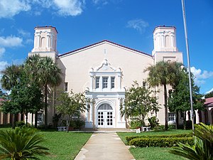
H.B. Plant High School is a public high school located in the neighborhood of South Tampa in Tampa, Florida, United States. It opened in 1927 between South Himes Avenue on the east and Dale Mabry Highway on the west. The school is named after railroad and hotel tycoon Henry B. Plant, who connected Tampa to the United States railroad system in 1884.
Academy of the Holy Names (Florida)
Private school in Tampa, , Florida, United States
Distance: Approx. 1632 meters
Latitude and longitude: 27.91472222,-82.49361111
The Academy of the Holy Names in Tampa, Florida, is a Catholic, coeducational elementary school and a college preparatory high school for young women, sponsored by the Sisters of the Holy Names of Jesus and Mary. It is the oldest Catholic school on Florida's West Coast and the second oldest high school in the state.

LeClaire Apartments
United States historic place
Distance: Approx. 1475 meters
Latitude and longitude: 27.92277778,-82.49361111
The LeClaire Apartments is a historic apartment building in Tampa, Florida, United States. It is located at 3013 through 3015 San Carlos Street. It was designed by Tampa architect Fred J. James.
Sunset Park (Tampa)
Neighborhood in Hillsborough, Florida, United States
Distance: Approx. 1455 meters
Latitude and longitude: 27.91888889,-82.52305556
Sunset Park is a neighborhood within the city limits of Tampa, Florida. As of the 2000 census the neighborhood had a population of 3,520. The ZIP Code serving the neighborhood is 33629.

Roosevelt Elementary School (Tampa, Florida)
United States historic place
Distance: Approx. 1183 meters
Latitude and longitude: 27.91638889,-82.49777778
The Roosevelt Elementary School is a historic U.S. school in Tampa, Florida. It is a part of Hillsborough County Public Schools. It is located at 3205 South Ferdinand Avenue and was constructed in 1925.
Palma Ceia West
Neighborhood in Hillsborough, Florida, United States
Distance: Approx. 970 meters
Latitude and longitude: 27.92833333,-82.51416667
Palma Ceia West is a neighborhood within the city limits of Tampa, Florida, located just west of Palma Ceia. As of the 2000 census the neighborhood had a population of 2,531. The ZIP Codes serving the neighborhood are 33609 and 33629.
Virginia Park (Tampa)
Neighborhood in Hillsborough, Florida, United States
Distance: Approx. 483 meters
Latitude and longitude: 27.91916667,-82.50416667
Virginia Park is a neighborhood within the city limits of Tampa, Florida. As of the 2000 census the neighborhood had a population of 4,378. The ZIP Codes serving the area are 33611 and 33629.
Culbreath Bayou
Neighborhood in Hillsborough, Florida, United States
Distance: Approx. 1721 meters
Latitude and longitude: 27.93138889,-82.52166667
Culbreath Bayou is a neighborhood within the city limits of Tampa, Florida. As of the 2000 census the neighborhood had a population of 290. The ZIP Code serving the neighborhood is 33629.

Britton Plaza Shopping Center
Shopping plaza in Tampa, Florida
Distance: Approx. 1688 meters
Latitude and longitude: 27.906527,-82.504152
Britton Plaza Shopping Center is a 522,689-square-foot (48,559.4 m2) [1] open-air shopping plaza in the Fair Oaks - Manhattan Manor neighborhood of Tampa, Florida (on the corner of Dale Mabry Highway and Euclid Avenue). The plaza was built in 1956 and includes these anchors: Publix Super Market, Bealls Outlet, Tuesday Morning, Stein Mart, Burlington Coat Factory, Marshall's, Michaels, and Big Lots, as well as a GNC, Taco Bell, and a variety of local stores including The Perfect Gift which opened in 2011. The plaza also has an eight-screen theater, operated by Five Star Cinemas, which reopened in August 2009.[2].
Maryland Manor
Neighborhood in Hillsborough, Florida, United States
Distance: Approx. 693 meters
Latitude and longitude: 27.9175,-82.51416667
Maryland Manor is a neighborhood in the southern area of Tampa, Florida, which represents District 4 of the Tampa City Council. The 2000 census numbers were unavailable, however, the latest estimated population was 1,616.

Datz
Restaurant in South Tampa, Florida, USA
Distance: Approx. 1494 meters
Latitude and longitude: 27.92194444,-82.49333333
Datz was a restaurant and bar in South Tampa, Florida, known for its deli and gastropub offerings. It was the flagship restaurant of Datz Restaurant Group. Since its inception, the Datz Restaurant Group had expanded to include Dough, a coffee and sweets shop that opened in 2012, and a Creole concept, Roux, that opened in Fall 2014, and closed in Summer 2023.
Weather in this IP's area
broken clouds
15 Celsius
15 Celsius
14 Celsius
16 Celsius
1020 hPa
90 %
1020 hPa
1020 hPa
10000 meters
4.12 m/s
70 degree
75 %