208.89.5.132 - IP Lookup: Free IP Address Lookup, Postal Code Lookup, IP Location Lookup, IP ASN, Public IP
Country:
Region:
City:
Location:
Time Zone:
Postal Code:
IP information under different IP Channel
ip-api
Country
Region
City
ASN
Time Zone
ISP
Blacklist
Proxy
Latitude
Longitude
Postal
Route
Luminati
Country
ASN
Time Zone
America/Chicago
ISP
TELOV-FL-TPA
Latitude
Longitude
Postal
IPinfo
Country
Region
City
ASN
Time Zone
ISP
Blacklist
Proxy
Latitude
Longitude
Postal
Route
IP2Location
208.89.5.132Country
Region
florida
City
tampa
Time Zone
America/New_York
ISP
Language
User-Agent
Latitude
Longitude
Postal
db-ip
Country
Region
City
ASN
Time Zone
ISP
Blacklist
Proxy
Latitude
Longitude
Postal
Route
ipdata
Country
Region
City
ASN
Time Zone
ISP
Blacklist
Proxy
Latitude
Longitude
Postal
Route
Popular places and events near this IP address

Oldsmar, Florida
City in Florida, United States
Distance: Approx. 2517 meters
Latitude and longitude: 28.03416667,-82.665
Oldsmar is a city in Pinellas County, Florida, United States. As of the 2020 census, the city had a population of 14,898. The Oldsmar name dates to April 12, 1916, when automobile pioneer Ransom E. Olds purchased 37,541 acres (151.92 km2) of land north of Tampa Bay to establish a planned community.

Safety Harbor, Florida
City in Florida, United States of America
Distance: Approx. 4707 meters
Latitude and longitude: 28.005,-82.695
Safety Harbor is a city on the west shore of Tampa Bay in Pinellas County, Florida, United States. It was settled in 1823 and incorporated in 1917. The population was 17,072 at the 2020 census.

Philippe Park
Distance: Approx. 4642 meters
Latitude and longitude: 28.00527778,-82.69277778
Philippe Park is a Pinellas County park located in Safety Harbor, Florida. The park is named after Odet Philippe, who is credited with introducing grapefruit to Florida. It is situated on 122 acres (0.49 km2) that was once part of Philippe's plantation.

Tampa Bay Downs
Distance: Approx. 4017 meters
Latitude and longitude: 28.04833333,-82.64555556
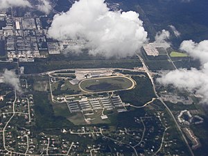
Tampa Bay Downs is an American Thoroughbred horse racing facility located in Westchase in Hillsborough County in the U.S. state of Florida, just outside Tampa. It opened in 1926 under the name Tampa Downs, and has also been known as Sunshine Park and Florida Downs and Turf Club.
WXGL
Radio station in St. Petersburg, Florida
Distance: Approx. 3345 meters
Latitude and longitude: 28.03944444,-82.65333333
WXGL (107.3 FM) is a commercial radio station licensed to St. Petersburg, Florida, and serving the Tampa Bay Area. It is owned by Cox Media Group and calls itself "The Eagle - Tampa Bay's Classic Hits." WXGL airs a classic hits radio format that leans toward classic rock, primarily from the 1980s and 1990s, although occasionally going older.

Countryside High School
Public high school in Clearwater, Florida
Distance: Approx. 3573 meters
Latitude and longitude: 28.023285,-82.711387
Countryside High School, also known as CHS, is a public high school located in Clearwater, Florida. Established in 1980, it is a part of the Pinellas County Schools system, and is one of the larger schools in Pinellas County. It draws students from Dunedin, suburban east Clearwater, Safety Harbor, and Oldsmar.
Countryside Mall (Clearwater, Florida)
Shopping mall in Clearwater, Florida
Distance: Approx. 5671 meters
Latitude and longitude: 28.01694444,-82.73333333
Countryside Mall (formerly Westfield Countryside) is a shopping mall in Clearwater, Florida. Situated near the coastline on the Gulf Coast, it serves over 9 million customers every year, and is home to five anchor stores, a 12-screen CMX Cinemas, numerous restaurants, and an ice skating rink.

Safety Harbor site
Archaeological site in Florida, United States
Distance: Approx. 4288 meters
Latitude and longitude: 28.00888889,-82.6775
The Safety Harbor site is an archaeological site in Philippe Park at 2525 Philippe Parkway in Safety Harbor, Florida, United States. It is the type site for the Safety Harbor culture, and includes the largest remaining mound in the Tampa Bay area. It was designated a National Historic Landmark in 1964.
Mease Countryside Hospital
Hospital in Florida, United States
Distance: Approx. 2294 meters
Latitude and longitude: 28.03891,-82.70806
Mease Countryside Hospital is a hospital in Safety Harbor, Florida.

Mobbly Bayou Preserve
Nature preserve in Pinellas County, Florida
Distance: Approx. 4134 meters
Latitude and longitude: 28.0228,-82.6541
Mobbly Bayou Preserve is a 396-acre (160 ha) county preserve located at the north end of upper Tampa Bay in the city of Oldsmar in Pinellas County in the U.S. state of Florida. The preserve encompasses a wide diversity of upland and coastal plant communities. The preserve is managed through an interlocal agreement with the city of Oldsmar, which is responsible for managing two recreational areas.
Lake Valencia (Pinellas County, Florida)
Lake in the state of Florida, United States
Distance: Approx. 4639 meters
Latitude and longitude: 28.0624,-82.7301
Lake Valencia, a natural lake located in Pinellas County, Florida, is the lake around which the Lake Valencia deed-restricted community of 291 homes was built. This lake is completely surrounded by residences and the west end can be accessed at Parson Brown Lane. Lake Valencia only has access at Parson Brown Lane.

Palm Harbor Museum
Distance: Approx. 6009 meters
Latitude and longitude: 28.049,-82.7475
The Palm Harbor Museum (formerly called North Pinellas Historical Museum) is located in the historic Hartley House in Palm Harbor, Florida. The house was built by Thomas W. Hartley, between 1914 and 1919, on property bought by his father, James Hartley, about 1880. The house was designed to accommodate the Hartley Family (Thomas, his wife Ida Stanton Hartley and their children Lucy, Clarine, Leonard and Orion).
Weather in this IP's area
scattered clouds
15 Celsius
15 Celsius
14 Celsius
16 Celsius
1020 hPa
89 %
1020 hPa
1019 hPa
10000 meters
2.24 m/s
3.13 m/s
127 degree
40 %