208.89.5.100 - IP Lookup: Free IP Address Lookup, Postal Code Lookup, IP Location Lookup, IP ASN, Public IP
Country:
Region:
City:
Location:
Time Zone:
Postal Code:
IP information under different IP Channel
ip-api
Country
Region
City
ASN
Time Zone
ISP
Blacklist
Proxy
Latitude
Longitude
Postal
Route
Luminati
Country
ASN
Time Zone
America/Chicago
ISP
TELOV-FL-TPA
Latitude
Longitude
Postal
IPinfo
Country
Region
City
ASN
Time Zone
ISP
Blacklist
Proxy
Latitude
Longitude
Postal
Route
IP2Location
208.89.5.100Country
Region
florida
City
sun city
Time Zone
America/New_York
ISP
Language
User-Agent
Latitude
Longitude
Postal
db-ip
Country
Region
City
ASN
Time Zone
ISP
Blacklist
Proxy
Latitude
Longitude
Postal
Route
ipdata
Country
Region
City
ASN
Time Zone
ISP
Blacklist
Proxy
Latitude
Longitude
Postal
Route
Popular places and events near this IP address

Apollo Beach, Florida
Census-designated place in Florida, United States
Distance: Approx. 7463 meters
Latitude and longitude: 27.77194444,-82.41083333
Apollo Beach is an unincorporated census-designated place in Hillsborough County, Florida, United States. The population was 14,055 at the 2010 census, up from 7,444 at the 2000 census.

Ruskin, Florida
Census-designated place in Florida, United States
Distance: Approx. 6765 meters
Latitude and longitude: 27.71472222,-82.43361111
Ruskin is an unincorporated census-designated place in Hillsborough County, Florida, United States. The area was part of the chiefdom of the Uzita at the time of the Hernando de Soto expedition in 1539. The community was founded August 7, 1908, on the shores of the Little Manatee River.

Wimauma, Florida
Census-designated place in Florida, United States
Distance: Approx. 4765 meters
Latitude and longitude: 27.70972222,-82.31777778
Wimauma is an unincorporated census-designated place in Hillsborough County, Florida, United States. The population was 6,373 at the 2010 census, up from 4,246 at the 2000 census.

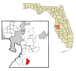
Sun City Center, Florida
Census-designated place in Florida, United States
Distance: Approx. 782 meters
Latitude and longitude: 27.71333333,-82.35972222
Sun City Center is an unincorporated census-designated place (CDP) in southern Hillsborough County, Florida, United States. It is located south of Tampa and north of Sarasota on I-75. As of the 2020 census, the population was 30,952.

Little Manatee River State Park
State park in Florida, United States
Distance: Approx. 5349 meters
Latitude and longitude: 27.67111111,-82.35611111
Little Manatee River State Park is a 2,433-acre (985 ha) Florida State Park located 5 miles (8.0 km) south of Sun City, off U.S. Route 301 on Lightfoot Road and along the Little Manatee River. The park was established in 1974 as Little Manatee River State Recreation Area with 663 hectares. It was designated as a state park in March 1999.

A. P. Dickman House
Historic house in Florida, United States
Distance: Approx. 6999 meters
Latitude and longitude: 27.71722222,-82.43611111
The A. P. Dickman House, also known as the Ruskin House Bed and Breakfast, is a historic home in Ruskin, Florida built in 1911. It is located at 120 Dickman Drive, Southeast. It was added to the National Register of Historic Places in 2000.

George McA. Miller House
Historic house in Florida, United States
Distance: Approx. 6883 meters
Latitude and longitude: 27.71361111,-82.43472222
The George McA. Miller House (also known as the Ruskin Women's Club) is a historic home in Ruskin, Florida. It is located at 508 Tamiami Trail. It was built in early 1900s as the residence of George McAnelly Miller, president of Ruskin College and his wife Addie Dickman Miller, the college's vice-president.
Earl J. Lennard High School
Public high school in the United States
Distance: Approx. 3882 meters
Latitude and longitude: 27.72297222,-82.40416667
Earl J. Lennard High School is a public high school located in Ruskin, Florida. It opened in 2006, mainly for the purpose to relieve overcrowding at East Bay High School in Gibsonton, Florida. It is named after former Hillsborough County Public Schools Superintendent, Dr.
Lake Wimauma
Lake in the state of Florida, United States
Distance: Approx. 5319 meters
Latitude and longitude: 27.7086,-82.3123
Lake Wimauma, on the south side of the town of Wimauma, Florida, could be considered two lakes, basically round in shape. When the water level is high, they are connected by a short narrow channel. The south part of the lake is much larger than the northern part.
North Ruskin, Florida
Unincorporated community in Florida, United States
Distance: Approx. 5956 meters
Latitude and longitude: 27.765,-82.395
North Ruskin is an unincorporated community located in southeastern Hillsborough County, Florida, United States, north of Ruskin. It is part of the census-designated place of Apollo Beach.
Apollo Beach Golf & Sea Club
Golf club in Apollo Beach, Florida, US
Distance: Approx. 7119 meters
Latitude and longitude: 27.76495006,-82.41476434
Apollo Beach Golf & Sea Club is a Robert Trent Jones-designed golf club in Apollo Beach, Florida, built in 1962. The course makes heavy use of the mangrove marshes and lagoons surrounding the course.
Sumner High School (Riverview, Florida)
Public high school in Riverview, Florida, United States
Distance: Approx. 6918 meters
Latitude and longitude: 27.76916667,-82.32444444
Jule F. Sumner High School is a public high school in Riverview, Florida. It opened in 2020 and was built to relieve overcrowding at East Bay High School in Gibsonton and Earl J. Lennard High School in Ruskin, though it also took some students from Joe E. Newsome High School in Lithia and from Durant High School in Plant City. The school is named after Jule F. Sumner, who was an early settler of the Southshore area.
Weather in this IP's area
scattered clouds
19 Celsius
19 Celsius
17 Celsius
21 Celsius
1021 hPa
69 %
1021 hPa
1019 hPa
10000 meters
3.58 m/s
4.92 m/s
103 degree
41 %