Country:
 USA
USARegion:
City:
Latitude and Longitude:
Time Zone:
Postal Code:
IP information under different IP Channel
ip-api
Country
Region
City
ASN
Time Zone
ISP
Blacklist
Proxy
Latitude
Longitude
Postal
Route
IPinfo
Country
Region
City
ASN
Time Zone
ISP
Blacklist
Proxy
Latitude
Longitude
Postal
Route
MaxMind
Country
Region
City
ASN
Time Zone
ISP
Blacklist
Proxy
Latitude
Longitude
Postal
Route
Luminati
Country
USASN
Time Zone
America/Chicago
ISP
123NET
Latitude
Longitude
Postal
db-ip
Country
Region
City
ASN
Time Zone
ISP
Blacklist
Proxy
Latitude
Longitude
Postal
Route
ipdata
Country
Region
City
ASN
Time Zone
ISP
Blacklist
Proxy
Latitude
Longitude
Postal
Route
Popular places and events near this IP address

Neuse Township, Wake County, North Carolina
Township in Wake County, North Carolina, U.S.
Distance: Approx. 4085 meters
Latitude and longitude: 35.8699522,-78.5887951
Neuse Township (also designated Township 13) is one of twenty townships within Wake County, North Carolina, United States. As of the 2010 census, Neuse Township had a population of 73,617, a 52.6% increase over 2000. Neuse Township, occupying 27.5 square miles (71.2 km2) in north-central Wake County, is almost completely occupied by portions of the city of Raleigh.
WRAL Soccer Center
Distance: Approx. 4583 meters
Latitude and longitude: 35.884689,-78.54818
The WRAL Soccer Center is a soccer complex featuring a 3,200-seat, lighted soccer-specific stadium located on Perry Creek Road in Raleigh, North Carolina. It is situated between Capital Boulevard (US Route 1) and Louisburg Road (NC Route 401), and just north of Interstate 540. The complex features a total of 25 soccer pitches.
Ravenscroft School
School in Raleigh, North Carolina, United States
Distance: Approx. 4299 meters
Latitude and longitude: 35.88416667,-78.63
Ravenscroft School is a coed independent private school located in Raleigh, North Carolina. The school enrolls students between PreKindergarten and 12th grade, and serves 1,254 students. The school has three divisions: Lower School, Middle School and Upper School.

North Carolina's 2nd congressional district
U.S. House district for North Carolina
Distance: Approx. 4151 meters
Latitude and longitude: 35.87,-78.6
North Carolina's 2nd congressional district is located in the central part of the state. The district contains most of Wake County. Prior to court-mandated redistricting in 2019, it also included northern Johnston County, southern Nash County, far western Wilson County, and all of Franklin and Harnett counties.

Capehart House
Historic house in North Carolina, United States
Distance: Approx. 4396 meters
Latitude and longitude: 35.94111111,-78.5675
The Capehart House is a Queen Anne style house built circa 1898 by Charles P. Snuggs for Lucy Catherine Capehart and her second husband, B. A. Capehart. Located on 424 North Blount Street in Raleigh, Wake County, North Carolina, it is one of the best examples of Queen Anne style architecture still standing in Raleigh. The Capehart House has an irregular skyline made of towers, turrets, dormers, and pediments, and luxurious facades ornamented with stained glass and decorative wooden designs.

Falls, North Carolina
Unincorporated community in North Carolina, United States
Distance: Approx. 3866 meters
Latitude and longitude: 35.94,-78.57944444
Falls (aka Falls of Neuse; Falls of the Neuse), is an unincorporated community in Wake County, North Carolina, United States, situated on Old Falls of Neuse Road, between Raleigh and Wake Forest, near the Wakefield Plantation development. Falls Dam, on the Neuse River, is within the community.
Neuse, North Carolina
Unincorporated community in North Carolina, US
Distance: Approx. 2236 meters
Latitude and longitude: 35.897373,-78.569169
Neuse is an unincorporated community in Neuse Township, Wake County, North Carolina, United States. Located on the Neuse River, it is approximately nine miles north-northeast of downtown Raleigh.

Neuse Christian Academy
Distance: Approx. 3844 meters
Latitude and longitude: 35.88777778,-78.62694444
Neuse Christian Academy (NCA), formerly known as Neuse Baptist Christian School, is a private, Christian, coeducational, primary and secondary day school located in Raleigh, North Carolina, United States. Also simply known as Neuse, the school seeks to educate students in a traditional Christian environment.

North Ridge Country Club
Country club and neighborhood in Raleigh, North Carolina
Distance: Approx. 3367 meters
Latitude and longitude: 35.8824163,-78.6136282
North Ridge Country Club is a member-owned country club located in northern Raleigh, North Carolina, along the North Ridge Estates neighborhood.

Falls of the Neuse Manufacturing Company
United States historic place
Distance: Approx. 3762 meters
Latitude and longitude: 35.93888889,-78.57888889
Falls of the Neuse Manufacturing Company, also known as the Manteo Manufacturing Company and Forest Manufacturing Company, is a historic paper mill complex located at Falls, Wake County, North Carolina. The main mill building was built from1854–1855, and is a three-story, quarried granite block building measuring 195 feet long and 54 feet wide. Located on the property is the stone mill dam, measuring about 400 feet wide and roughly 6 feet tall, and the one-story picker room, measuring 53 feet square.
Leesville, North Carolina
Unincorporated community in North Carolina, United States
Distance: Approx. 2864 meters
Latitude and longitude: 35.90722222,-78.55944444
Leesville is an unincorporated community located in Wake County, North Carolina, United States.
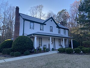
Pullen House
Historic plantation house in Raleigh, North Carolina
Distance: Approx. 469 meters
Latitude and longitude: 35.90694444,-78.59638889
Pullen House is a historic Victorian plantation house located in northern Raleigh, North Carolina. The house was the center of a small plantation in Wake County that was owned by the Pullen family. Richard Stanhope Pullen, a local businessman and philanthropist who funded the construction of Pullen Park, was born here.
Weather in this IP's area
scattered clouds
15 Celsius
15 Celsius
14 Celsius
17 Celsius
1019 hPa
86 %
1019 hPa
1006 hPa
10000 meters
2.57 m/s
40 degree
40 %
06:52:05
19:32:01