208.85.73.168 - IP Lookup: Free IP Address Lookup, Postal Code Lookup, IP Location Lookup, IP ASN, Public IP
Country:
Region:
City:
Location:
Time Zone:
Postal Code:
IP information under different IP Channel
ip-api
Country
Region
City
ASN
Time Zone
ISP
Blacklist
Proxy
Latitude
Longitude
Postal
Route
Luminati
Country
Region
mo
City
stlouis
ASN
Time Zone
America/Chicago
ISP
REJISCOMM-NET
Latitude
Longitude
Postal
IPinfo
Country
Region
City
ASN
Time Zone
ISP
Blacklist
Proxy
Latitude
Longitude
Postal
Route
IP2Location
208.85.73.168Country
Region
missouri
City
saint louis
Time Zone
America/Chicago
ISP
Language
User-Agent
Latitude
Longitude
Postal
db-ip
Country
Region
City
ASN
Time Zone
ISP
Blacklist
Proxy
Latitude
Longitude
Postal
Route
ipdata
Country
Region
City
ASN
Time Zone
ISP
Blacklist
Proxy
Latitude
Longitude
Postal
Route
Popular places and events near this IP address

Roman Catholic Archdiocese of St. Louis
Latin Catholic ecclesiastical jurisdiction in US
Distance: Approx. 520 meters
Latitude and longitude: 38.64277778,-90.25722222
The Archdiocese of St. Louis (Latin: Archidiœcesis Sancti Ludovici) is a Latin Church ecclesiastical territory, or archdiocese, of the Catholic Church in the eastern part of the U.S. state of Missouri. As of November 2024, the archdiocese is led by Archbishop Mitchell Thomas Rozanski, formerly the Bishop of Springfield in Massachusetts.

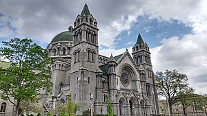
Cathedral Basilica of Saint Louis (St. Louis)
Church in Missouri, United States
Distance: Approx. 421 meters
Latitude and longitude: 38.6425,-90.25472222
The Cathedral Basilica of Saint Louis, also known as the Saint Louis Cathedral, is a Catholic cathedral in the Central West End neighborhood of St. Louis, Missouri. Completed in 1914, it is the mother church of the Archdiocese of St.

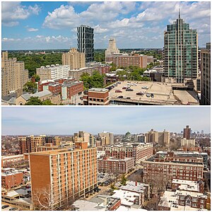
Central West End, St. Louis
Neighborhood of St. Louis in Missouri, United States
Distance: Approx. 656 meters
Latitude and longitude: 38.6403,-90.2548
The Central West End is a neighborhood in St. Louis, Missouri, stretching from Midtown's western edge to Union Boulevard and bordering on Forest Park with its array of free cultural institutions. It includes the Cathedral Basilica of Saint Louis (the New Cathedral) on Lindell Boulevard at Newstead Avenue, which houses the second-largest collection of mosaics in the world.

Ranken Technical College
Private college in St. Louis, Missouri, US
Distance: Approx. 903 meters
Latitude and longitude: 38.65332,-90.24842
Ranken Technical College is a private technical school in St. Louis, Missouri. It offers programs in five main divisions: Automotive, Electrical, Construction, Information Technology, and Manufacturing.
Rosati-Kain High School
Catholic school in St. Louis, Missouri, US
Distance: Approx. 452 meters
Latitude and longitude: 38.642,-90.2538
Rosati-Kain Academy (Formerly Rosati-Kain High School) is an all-girls Catholic high school in St. Louis, Missouri. Rosati-Kain is accredited as a college preparatory school by the North Central Association, the Missouri Department of Education, and the Roman Catholic Archdiocese of Saint Louis.

Second Presbyterian Church (St. Louis, Missouri)
Historic church in Missouri, United States
Distance: Approx. 285 meters
Latitude and longitude: 38.6475,-90.25555556
Second Presbyterian Church is a historic church at 4501 Westminster Place in St. Louis, Missouri.

Kate Chopin House (St. Louis, Missouri)
Historic house in Missouri, United States
Distance: Approx. 479 meters
Latitude and longitude: 38.64305556,-90.24888889
The Kate Chopin House, located at 4232 McPherson Avenue in St. Louis, Missouri, is the former home of author Kate Chopin. The house was built in 1897 by contractor Oscar F. Humphrey.

Butler House (St. Louis, Missouri)
Historic house in Missouri, United States
Distance: Approx. 732 meters
Latitude and longitude: 38.640616,-90.257735
The Butler House is a turreted, brick house built in 1892 for prominent St. Louis tobacco manufacturer James Gay Butler. It was designed in the Queen Anne style by Albert Knell, a Canadian architect.
KDNA (St. Louis)
FM radio station in Missouri, 1969 to 1972
Distance: Approx. 368 meters
Latitude and longitude: 38.6456,-90.2487
KDNA (102.5 FM) was a St. Louis, Missouri freeform non-commercial community radio station from February 8, 1969, until sometime in 1972. It billed itself as "Radio Free St.

Left Bank Books (St. Louis)
Independent bookstore in St. Louis, Missouri
Distance: Approx. 760 meters
Latitude and longitude: 38.648588,-90.26099
Left Bank Books is an independent bookstore located at 399 N. Euclid Street in the Central West End neighborhood of St. Louis, Missouri. It is the oldest independently operated bookstore in St.
Douglass University
African American university founded in 1926
Distance: Approx. 497 meters
Latitude and longitude: 38.64904,-90.24872
Douglass University was a university established for African Americans in 1926 in located in St. Louis, Missouri. It was the second university in the state of Missouri to admit African American students; and it was the second U.S. law school that admitted African Americans for a full law degree.

Bel Air Motel
Historic motel in St. Louis, Missouri, US
Distance: Approx. 777 meters
Latitude and longitude: 38.64277778,-90.26083333
Bel Air Motel, also known as Bel Air West, is a historic building and motel in the Central West End neighborhood of St. Louis, Missouri. It was listed on the National Register of Historic Places in 2009.
Weather in this IP's area
mist
8 Celsius
8 Celsius
7 Celsius
10 Celsius
1013 hPa
95 %
1013 hPa
994 hPa
2414 meters
20 %
