208.84.73.242 - IP Lookup: Free IP Address Lookup, Postal Code Lookup, IP Location Lookup, IP ASN, Public IP
Country:
Region:
City:
Location:
Time Zone:
Postal Code:
IP information under different IP Channel
ip-api
Country
Region
City
ASN
Time Zone
ISP
Blacklist
Proxy
Latitude
Longitude
Postal
Route
Luminati
Country
Region
mn
City
minneapolis
ASN
Time Zone
America/Chicago
ISP
VER
Latitude
Longitude
Postal
IPinfo
Country
Region
City
ASN
Time Zone
ISP
Blacklist
Proxy
Latitude
Longitude
Postal
Route
IP2Location
208.84.73.242Country
Region
minnesota
City
coon rapids
Time Zone
America/Chicago
ISP
Language
User-Agent
Latitude
Longitude
Postal
db-ip
Country
Region
City
ASN
Time Zone
ISP
Blacklist
Proxy
Latitude
Longitude
Postal
Route
ipdata
Country
Region
City
ASN
Time Zone
ISP
Blacklist
Proxy
Latitude
Longitude
Postal
Route
Popular places and events near this IP address

Coon Rapids, Minnesota
City in Minnesota, United States
Distance: Approx. 1506 meters
Latitude and longitude: 45.17222222,-93.30416667
Coon Rapids is a northern suburb of Minneapolis, and is the second-largest city by population in Anoka County, Minnesota, United States. The population was 63,599 at the 2020 census, making it the fifteenth largest city in Minnesota and the seventh largest Twin Cities suburb.

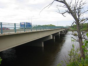
Richard P. Braun Bridge
Bridge in Minnesota-Coon Rapids, Minnesota
Distance: Approx. 4319 meters
Latitude and longitude: 45.129151,-93.298918
Richard P. Braun Bridge is a pair of 10-span concrete girder bridges spanning the Mississippi River between Brooklyn Park, Minnesota and Coon Rapids, Minnesota. The eastbound span was built in 1985 to connect Minnesota State Highway 252 with Minnesota State Highway 610 in Coon Rapids. The westbound span was built in 1999 as part of the continued construction of Highway 610 through Brooklyn Park.
Springbrook Nature Center
Park and nature reserve located in Fridley, Minnesota
Distance: Approx. 5818 meters
Latitude and longitude: 45.12377,-93.27458
Springbrook Nature Center is a 127-acre (0.51 km2) park and nature reserve located in Fridley, Minnesota. Springbrook features an interpretive building, over three miles (5 km) of hiking trails through wooded and wetland areas, and various public shelters. The mission of Springbrook Nature Center is to preserve the integrity of and enable access to the natural resource base.

Coon Rapids High School
Public high school in Coon Rapids, Minnesota, United States
Distance: Approx. 1955 meters
Latitude and longitude: 45.182,-93.326
Coon Rapids High School (CRHS) is a public high school in Coon Rapids, Minnesota, United States. It is part of the Anoka-Hennepin School District 11 and participates in the University of Minnesota's College in the Schools program.
Champlin Park High School
Public school in Champlin, Minnesota, United States
Distance: Approx. 3174 meters
Latitude and longitude: 45.1501415,-93.354898
Champlin Park High School is a four-year public high school in Champlin, Minnesota, United States. The school's name comes from the combination of Brooklyn Park and Champlin. Champlin Park's first graduating class was in 1993.

Coon Rapids Dam
Dam on the Mississippi River
Distance: Approx. 2441 meters
Latitude and longitude: 45.14388889,-93.31138889
The Coon Rapids Dam is a concrete gravity dam on the Mississippi River located in Brooklyn Park and Coon Rapids, Minnesota. It is approximately 12 miles (19 km) north of downtown Minneapolis. Between 1914 and 1966, it provided hydroelectric power generation for northern Twin Cities suburbs.
Mercy Hospital (Minnesota)
Hospital in Minnesota, United States
Distance: Approx. 4363 meters
Latitude and longitude: 45.18289,-93.36969
Mercy Hospital, located in Coon Rapids, Minnesota, is a 471-bed non-profit hospital that serves the northern Twin Cities metropolitan area. Mercy Hospital is a part of Allina Health.

Coon Rapids–Riverdale station
Commuter rail station in Minnesota, US
Distance: Approx. 3803 meters
Latitude and longitude: 45.19111111,-93.35138889
Coon Rapids–Riverdale station is a commuter rail station in Coon Rapids, Minnesota, located at 3050 Northdale Boulevard NW, south of the Riverdale shopping centers. It is served by the Northstar Commuter Rail line. The station features bicycle lockers and a park and ride lot with capacity for 466 vehicles.
Coon Rapids–Foley Boulevard station
Planned rail station in Minnesota, US
Distance: Approx. 3749 meters
Latitude and longitude: 45.14138889,-93.28611111
Coon Rapids–Foley Boulevard is a planned infill station on the Northstar commuter rail line in Coon Rapids, Minnesota, United States, at the site of a current Metro Transit park and ride facility. The station was originally included in Northstar plans, but it was cut in order to meet the Federal Transit Administration's cost-effectiveness index (CEI). The current park-and-ride facility is located on a sliver of land in between Minnesota State Highway 610 and Foley Boulevard.
Bunker Beach
Outdoor waterpark in Minnesota
Distance: Approx. 5814 meters
Latitude and longitude: 45.21027778,-93.28361111
Bunker Beach is a water park in Coon Rapids, Minnesota, United States, within the 1,700-acre (690 ha) Bunker Hills Regional Park. It is owned by the Anoka County Parks and Recreation Department.
Riverdale Village
Shopping mall in Minnesota, United States
Distance: Approx. 4694 meters
Latitude and longitude: 45.20056,-93.35223
Riverdale Village is an outdoor shopping center in Coon Rapids, Minnesota, United States. It opened in 1999 and has over 75 stores. It is located just off of U.S. Route 10.
Andrews Park (Champlin, Minnesota)
Distance: Approx. 4196 meters
Latitude and longitude: 45.16777778,-93.37361111
Andrews Park, Champlin Minnesota is a neighborhood park in Champlin, Minnesota. Andrews Park is a popular place in the community during the spring and summer seasons, providing a playground, splash pad with concession stand, athletic facilities, and a picnic pavilion which may be used for family reunions, birthday parties, and community events. In 2022, the Andrews Park Splash Pad will be open May 31 thru September 4.
Weather in this IP's area
clear sky
-20 Celsius
-27 Celsius
-21 Celsius
-19 Celsius
1024 hPa
79 %
1024 hPa
988 hPa
10000 meters
4.12 m/s
290 degree