208.84.58.104 - IP Lookup: Free IP Address Lookup, Postal Code Lookup, IP Location Lookup, IP ASN, Public IP
Country:
Region:
City:
Location:
Time Zone:
Postal Code:
IP information under different IP Channel
ip-api
Country
Region
City
ASN
Time Zone
ISP
Blacklist
Proxy
Latitude
Longitude
Postal
Route
Luminati
Country
Region
co
City
holyoke
ASN
Time Zone
America/Denver
ISP
PCTCNET-AS1
Latitude
Longitude
Postal
IPinfo
Country
Region
City
ASN
Time Zone
ISP
Blacklist
Proxy
Latitude
Longitude
Postal
Route
IP2Location
208.84.58.104Country
Region
colorado
City
holyoke
Time Zone
America/Denver
ISP
Language
User-Agent
Latitude
Longitude
Postal
db-ip
Country
Region
City
ASN
Time Zone
ISP
Blacklist
Proxy
Latitude
Longitude
Postal
Route
ipdata
Country
Region
City
ASN
Time Zone
ISP
Blacklist
Proxy
Latitude
Longitude
Postal
Route
Popular places and events near this IP address
Phillips County, Colorado
County in Colorado, United States
Distance: Approx. 4354 meters
Latitude and longitude: 40.59,-102.35
Phillips County is a county located in the U.S. state of Colorado. As of the 2020 census, the population was 4,530. The county seat is Holyoke.
Holyoke, Colorado
City in Colorado, United States
Distance: Approx. 142 meters
Latitude and longitude: 40.58194444,-102.30111111
Holyoke is the home rule municipality that is the county seat and the most populous municipality of Phillips County, Colorado, United States. As of the 2020 United States Census, its population was 2,346.
KSTH
Radio station in Holyoke, Colorado
Distance: Approx. 1739 meters
Latitude and longitude: 40.57944444,-102.31972222
KSTH (92.3 FM) is a radio station licensed to Holyoke, Colorado, United States. The station is owned by Armada Media - Mccook. The station has a construction permit from the U.S. Federal Communications Commission (FCC) to increase of effective radiated power to 35,000 watts.
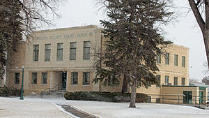
Phillips County Courthouse (Colorado)
United States historic place
Distance: Approx. 223 meters
Latitude and longitude: 40.58388889,-102.30111111
The Phillips County Courthouse, home of the Phillips Combined Court, located at 221 Interocean Ave. in Holyoke, Colorado was built in 1935 in Moderne style. It is significant for association with New Deal programs; the Public Works Administration built it, and it is the only surviving PWA project in the county.
W. E. Heginbotham House
Historic house in Colorado, United States
Distance: Approx. 338 meters
Latitude and longitude: 40.58055556,-102.30277778
The W. E. Heginbotham House, located at 539 S. Baxter in Holyoke, Colorado serves as Holyoke's public library and is known as Heginbotham Library. It is a historic building, was built during 1919–1921, and is listed on the National Register of Historic Places. It was deemed significant on a statewide level, rather than just locally, for its Craftsman architecture, especially "rare for a sparsely populated rural county", and for its landscaped gardens "which form a remarkable ensemble of designed spaces, plant materials and architectural features that are essentially intact.
Hargreaves Homestead Rural Historic District
Historic district in Colorado, United States
Distance: Approx. 8575 meters
Latitude and longitude: 40.50527778,-102.29805556
The Hargreaves Homestead Rural Historic District, about five miles south of Holyoke, Colorado, is a 320-acre (1.3 km2) farm property, a historic district that was listed on the National Register of Historic Places in 2013. In 2013, it included seven contributing buildings, 9 contributing structures, one contributing site, and two contributing objects, as well as 4 non-contributing resources.
Millage Farm Rural Historic District
Historic district in Colorado, United States
Distance: Approx. 3044 meters
Latitude and longitude: 40.555466,-102.306429
The Millage Farm Rural Historic District in Phillips County, Colorado near Haxtun, Colorado, is a 160 acres (0.65 km2) farm which was listed on the National Register of Historic Places in 2013. The district includes nine contributing buildings, ten contributing structures, one contributing site, and two contributing objects.
Weather in this IP's area
scattered clouds
3 Celsius
-0 Celsius
3 Celsius
3 Celsius
1022 hPa
58 %
1022 hPa
888 hPa
10000 meters
3.54 m/s
4.29 m/s
186 degree
25 %


