Country:
Region:
City:
Latitude and Longitude:
Time Zone:
Postal Code:
IP information under different IP Channel
ip-api
Country
Region
City
ASN
Time Zone
ISP
Blacklist
Proxy
Latitude
Longitude
Postal
Route
Luminati
Country
ASN
Time Zone
America/Chicago
ISP
IMMEDION
Latitude
Longitude
Postal
IPinfo
Country
Region
City
ASN
Time Zone
ISP
Blacklist
Proxy
Latitude
Longitude
Postal
Route
db-ip
Country
Region
City
ASN
Time Zone
ISP
Blacklist
Proxy
Latitude
Longitude
Postal
Route
ipdata
Country
Region
City
ASN
Time Zone
ISP
Blacklist
Proxy
Latitude
Longitude
Postal
Route
Popular places and events near this IP address

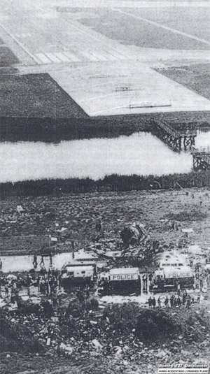
Eastern Air Lines Flight 66
1975 aviation accident
Distance: Approx. 1423 meters
Latitude and longitude: 40.64966667,-73.75208333
Eastern Air Lines Flight 66 was a regularly scheduled flight from New Orleans to New York City that crashed on June 24, 1975, while on approach to New York's John F. Kennedy International Airport, killing 113 of the 124 people on board.: 1 The crash was determined to be caused by wind shear caused by a microburst, but the failure of the airport and the flight crew to recognize the severe weather hazard was also a contributing factor.: 1
Springfield Gardens, Queens
Neighborhood in New York City
Distance: Approx. 478 meters
Latitude and longitude: 40.66,-73.77
Springfield Gardens is a neighborhood in the southeastern area of the New York City borough of Queens, bounded to the north by St. Albans, to the east by Laurelton and Rosedale, to the south by John F. Kennedy International Airport, and to the west by Farmers Boulevard. The neighborhood is served by Queens Community Board 12.

Laurelton station
Long Island Rail Road station in Queens, New York
Distance: Approx. 1667 meters
Latitude and longitude: 40.66853,-73.7518
Laurelton is a station on the Long Island Rail Road's Atlantic Branch, located at the intersection of 225th Street and 141st Road in the Laurelton neighborhood of Queens, New York City. It is 14.9 miles (24.0 km) from Penn Station in Midtown Manhattan.
Sundrome
Former terminal at JFK Airport in New York City
Distance: Approx. 1604 meters
Latitude and longitude: 40.647951,-73.7794
The Sundrome, later TWA Domestic Terminal and Terminal 6, was one of several terminals at John F. Kennedy International Airport. It was designed by I. M. Pei & Partners (now Pei Cobb Freed & Partners). Opened in 1969, it was initially used by National Airlines.
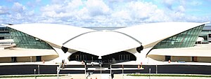
TWA Flight Center
Terminal at JFK Airport in Queens, New York
Distance: Approx. 1667 meters
Latitude and longitude: 40.64583333,-73.7775
The TWA Flight Center, also known as the Trans World Flight Center, is an airport terminal and hotel complex at John F. Kennedy International Airport (JFK) in New York City. The original terminal building, or head house, operated as a terminal from 1962 to 2001 and was adaptively repurposed in 2017 as part of the TWA Hotel. The head house is partially encircled by a replacement terminal building completed in 2008, and flanked by two buildings added for the hotel.

Springfield Junction (Long Island Rail Road)
Distance: Approx. 1736 meters
Latitude and longitude: 40.66758333,-73.7495
Springfield Junction was a junction between the Long Island Rail Road's Montauk Branch and Atlantic Branch in Laurelton, Queens, New York City, United States. It was located at the place where those two branches now begin to parallel, just east of Laurelton station and half a mile east of Springfield Boulevard. No rail station was located at the junction itself, however Springfield Gardens station was located nearby.
Higbie Avenue station
Long Island Railroad station in Queens, New York
Distance: Approx. 1697 meters
Latitude and longitude: 40.672328,-73.760102
Higbie Avenue was a railroad station along the Atlantic Branch of the Long Island Rail Road, in Queens, New York City. The station was located on 140th Avenue (formerly Higbie Avenue) and Edgewood Avenue in the Springfield section of Queens, New York City between Locust Manor and Laurelton stations.

JetBlue flight attendant incident
Aircraft incident involving disruptive flight attendant
Distance: Approx. 1757 meters
Latitude and longitude: 40.656,-73.786
The JetBlue flight attendant incident occurred after JetBlue Airways Flight 1052, from Pittsburgh to New York City on August 9, 2010, had landed at John F. Kennedy International Airport. Steven Slater, a veteran flight attendant announced over the plane's public address system that he had been abused by a passenger and was quitting his job. He then grabbed and drank two beers and exited the plane by deploying the evacuation slide and sliding down it.
Springfield Park (Queens)
Public park in Queens, New York
Distance: Approx. 560 meters
Latitude and longitude: 40.66166667,-73.76138889
Springfield Park is a public park in Springfield Gardens, in southeast Queens, New York City. It consists of 23.54 acres (9.53 ha), including the sizable Springfield Lake at its center. It is located on the west side of Springfield Boulevard between 145th Road and 147th Avenue, less than a mile north of JFK Airport.
Queens Detention Facility
Federal prison in New York City
Distance: Approx. 51 meters
Latitude and longitude: 40.65723,-73.764943
The Queens Detention Facility (QDF) is a federal prison in the Springfield Gardens neighborhood of Jamaica, Queens, New York City, and operated by the private prison company GEO Group. The facility opened in March 1997 under a contract between GEO Group and the U.S. Immigration and Customs Enforcement. When that agreement was not extended by ICE past its mid-2005 expiration, the United States Marshals Service contracted with GEO to house mostly pre-trial federal detainees here.

TWA Hotel
Hotel in Queens, New York
Distance: Approx. 1686 meters
Latitude and longitude: 40.64572,-73.77768
TWA Hotel is a hotel at John F. Kennedy International Airport in Queens, New York City, that opened on May 15, 2019. It uses the head house of the TWA Flight Center, designed by the architect Eero Saarinen and completed in 1962, and two flanking buildings added for the hotel project. It contains a total of 512 rooms, as well as conference space, several restaurants, and an aviation history museum.

Trans International Airlines Flight 863
1970 aviation accident
Distance: Approx. 1742 meters
Latitude and longitude: 40.65,-73.78333333
Trans International Airlines Flight 863 was a ferry flight from John F. Kennedy International Airport in New York City to Washington Dulles International Airport. On September 8, 1970, the Douglas DC-8 (registration N4863T) crashed during take-off from JFK's runway 13R. None of the 11 occupants, who were all crew members, survived. The probable cause of the accident was an asphalt-covered object lodged in between the right elevator and the right horizontal stabilizer, that jammed the elevator and caused the loss of pitch control.
Weather in this IP's area
broken clouds
9 Celsius
6 Celsius
7 Celsius
10 Celsius
1012 hPa
39 %
1012 hPa
1012 hPa
10000 meters
5.14 m/s
330 degree
75 %
06:42:26
16:37:19


