Country:
Region:
City:
Latitude and Longitude:
Time Zone:
Postal Code:
IP information under different IP Channel
ip-api
Country
Region
City
ASN
Time Zone
ISP
Blacklist
Proxy
Latitude
Longitude
Postal
Route
Luminati
Country
Region
id
City
maladcity
ASN
Time Zone
America/Boise
ISP
SUMOFIBER
Latitude
Longitude
Postal
IPinfo
Country
Region
City
ASN
Time Zone
ISP
Blacklist
Proxy
Latitude
Longitude
Postal
Route
db-ip
Country
Region
City
ASN
Time Zone
ISP
Blacklist
Proxy
Latitude
Longitude
Postal
Route
ipdata
Country
Region
City
ASN
Time Zone
ISP
Blacklist
Proxy
Latitude
Longitude
Postal
Route
Popular places and events near this IP address

Malad City, Idaho
City in Idaho, United States
Distance: Approx. 159 meters
Latitude and longitude: 42.19083333,-112.24916667
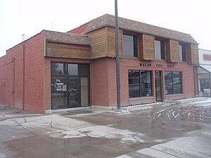
Malad City (also commonly known as Malad) is the only city and the county seat of Oneida County, Idaho, United States. In 2020 the population was 2,299 people. The city is named after the nearby Malad River, the name being French for "sickly".

Oneida County Courthouse (Idaho)
United States historic place
Distance: Approx. 842 meters
Latitude and longitude: 42.18666667,-112.24305556
Oneida County Courthouse in Malad, Idaho is an Art Deco building built as a Works Project Administration (WPA) project in 1939. It serves Oneida County, Idaho. It was listed on the National Register of Historic Places in 1987.
Pleasantview, Idaho
Unincorporated community in the state of Idaho, United States
Distance: Approx. 8191 meters
Latitude and longitude: 42.15611111,-112.33777778
Pleasantview is an unincorporated community in Oneida County, Idaho, United States. Pleasantview is located on Idaho State Highway 38 5 miles (8.0 km) west-southwest of Malad City.

Co-op Block and J. N. Ireland Bank
United States historic place
Distance: Approx. 752 meters
Latitude and longitude: 42.18638889,-112.245
The Co-op Block and J. N. Ireland Bank is a commercial block in Malad City, Idaho. It was added to the National Register of Historic Places on April 18, 1979. A section facing onto Main and a section facing onto Bannock were built in 1893, as part of an L-shaped structure built around a pre-existing wood-frame building at the corner.

Malad Second Ward Tabernacle
Historic church in Idaho, United States
Distance: Approx. 740 meters
Latitude and longitude: 42.18511667,-112.24881389
The Malad Second Ward Tabernacle is a tabernacle and meetinghouse of the Church of Jesus Christ of Latter-day Saints located in Malad City, Idaho. It is significant for its large scale and unorthodox adaptation of architectural styles, as well as its historical importance to Oneida County, which once was among the most populated counties in Idaho. It is, along with six other buildings in Oneida County, listed on the National Register of Historic Places.

United Presbyterian Church (Malad City, Idaho)
Historic church in Idaho, United States
Distance: Approx. 859 meters
Latitude and longitude: 42.18611111,-112.24347222
The United Presbyterian Church in Malad City, Idaho was built in 1882 and was listed on the National Register of Historic Places in 1979. Its NRHP nomination describes it as "a small and unpretentious brick chapel".

Jedd Jones House
Historic house in Idaho, United States
Distance: Approx. 576 meters
Latitude and longitude: 42.19083333,-112.24388889
The Jedd Jones House in Malad City, Idaho was built in 1905. It was listed on the National Register of Historic Places in 1979. Its NRHP nomination asserts:The wider architectural significance of the house stems from the impression of quality evinced by its precise and well-preserved rendering and architectural detail.

D.L. Evans Sr. Bungalow
Historic house in Idaho, United States
Distance: Approx. 532 meters
Latitude and longitude: 42.19,-112.24472222
The D.L. Evans Sr. Bungalow, located at 203 N. Main St in Malad City, Idaho, was built in 1915. It was listed on the National Register of Historic Places in 1979.
Weather in this IP's area
overcast clouds
8 Celsius
5 Celsius
8 Celsius
8 Celsius
999 hPa
44 %
999 hPa
846 hPa
10000 meters
6.14 m/s
10.36 m/s
193 degree
100 %
07:20:13
17:07:27