208.82.84.59 - IP Lookup: Free IP Address Lookup, Postal Code Lookup, IP Location Lookup, IP ASN, Public IP
Country:
Region:
City:
Location:
Time Zone:
Postal Code:
ISP:
ASN:
language:
User-Agent:
Proxy IP:
Blacklist:
IP information under different IP Channel
ip-api
Country
Region
City
ASN
Time Zone
ISP
Blacklist
Proxy
Latitude
Longitude
Postal
Route
db-ip
Country
Region
City
ASN
Time Zone
ISP
Blacklist
Proxy
Latitude
Longitude
Postal
Route
IPinfo
Country
Region
City
ASN
Time Zone
ISP
Blacklist
Proxy
Latitude
Longitude
Postal
Route
IP2Location
208.82.84.59Country
Region
virginia
City
christiansburg
Time Zone
America/New_York
ISP
Language
User-Agent
Latitude
Longitude
Postal
ipdata
Country
Region
City
ASN
Time Zone
ISP
Blacklist
Proxy
Latitude
Longitude
Postal
Route
Popular places and events near this IP address

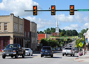
Christiansburg, Virginia
Town in Montgomery County, Virginia, USA
Distance: Approx. 1263 meters
Latitude and longitude: 37.14111111,-80.40777778
Christiansburg (formerly Hans Meadows) is a town in the southwestern portion of the commonwealth of Virginia, in the county of Montgomery. It has served as the seat of government for the county since 1792 when it was formally recognized by the Virginia General Assembly. Christiansburg is contiguously bordered on its north by the only other incorporated town in Montgomery County, Blacksburg.

Christiansburg Presbyterian Church
Historic house in Virginia, United States
Distance: Approx. 275 meters
Latitude and longitude: 37.12833333,-80.41138889
Christiansburg Presbyterian Church is a historic Presbyterian church located at 107 W. Main Street in Christiansburg, Montgomery County, Virginia. The church was organized in 1827. The building was erected in 1853 and is a four bay long, brick church building with a low hipped roof.
Phlegar Building
Historic commercial building in Virginia, United States
Distance: Approx. 64 meters
Latitude and longitude: 37.12944444,-80.40833333
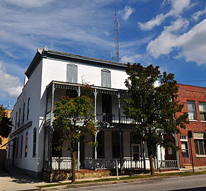
Phlegar Building is a historic office building located at Christiansburg, Montgomery County, Virginia. The original structure was built in the early 19th century, and extensively renovated after 1897. It is a three-story, rectangular brick building with Italianate style decorative details.
Surface House
Historic house in Virginia, United States
Distance: Approx. 1013 meters
Latitude and longitude: 37.13888889,-80.40833333
Surface House is a historic home located at Christiansburg, Montgomery County, Virginia. It was built about 1870, and is a one-story, double-pile center passage form frame dwelling on a stone foundation. It has a hipped roof surrounded by pairs of ornamental brackets in the eaves that also decorate the pedimented four-bay porch.
United States Post Office (Christiansburg, Virginia)
Historic post office in Virginia, United States
Distance: Approx. 58 meters
Latitude and longitude: 37.13027778,-80.40916667
US Post Office-Christiansburg is a historic post office building located at Christiansburg, Montgomery County, Virginia. It was designed and built in 1936, and was designed by the Office of the Supervising Architect of the Treasury Department under Louis A. Simon. The one-story, five-bay, brick building is in the Colonial Revival style.
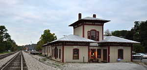
Cambria Freight Station
United States historic place
Distance: Approx. 1327 meters
Latitude and longitude: 37.14111111,-80.40416667
Cambria Freight Station, also known as Christiansburg Depot, is a historic freight station located at Christiansburg, Montgomery County, Virginia, US. It was built in 1868–1869, and is a wood-framed, one-story, U-shaped structure with a shallow hipped roof and deeply overhanging eaves in the Italianate style. A portion of the center section rises to form a tower-like second-story room, covered with an even shallower hipped roof. A long, one-story freight section extending eastward from the rear.
The Oaks (Christiansburg, Virginia)
Historic house in Virginia, United States
Distance: Approx. 479 meters
Latitude and longitude: 37.13277778,-80.405
The Oaks is a historic home located at Christiansburg, Montgomery County, Virginia. It was built in 1893, and is a two-story, asymmetrical Queen Anne style frame house. It features a wraparound porch, a polygonal tower, a polygonal turret, and a hipped roof with two cross gables and four brick chimneys.
Old Christiansburg Industrial Institute
United States historic place
Distance: Approx. 1078 meters
Latitude and longitude: 37.13916667,-80.40583333
Old Christiansburg Industrial Institute is a historic African American trade school complex located at Christiansburg, Montgomery County, Virginia. The complex includes the Hill School (1885), the Schaeffer Memorial Baptist Church (1885), and the Primary Annex (1888). The Hill School is a 2+1⁄2-story, cruciform-plan, gable-roof structure set on a low stone foundation.

South Franklin Street Historic District
Historic district in Virginia, United States
Distance: Approx. 339 meters
Latitude and longitude: 37.1275,-80.40638889
South Franklin Street Historic District is a national historic district located at Christiansburg, Montgomery County, Virginia. The district encompasses 26 contributing buildings in the town of Christiansburg. It includes principally single family brick and frame dwellings dated to the late-19th and early-20th centuries.

East Main Street Historic District (Christiansburg, Virginia)
Historic district in Virginia, United States
Distance: Approx. 389 meters
Latitude and longitude: 37.1325,-80.40611111
East Main Street Historic District is a national historic district located at Christiansburg, Montgomery County, Virginia. The district encompasses 45 contributing buildings and 1 contributing site in the town of Christiansburg. It includes principally single family brick and frame dwellings dated to the late-19th and early-20th centuries.

Cambria Historic District
Historic district in Virginia, United States
Distance: Approx. 389 meters
Latitude and longitude: 37.1325,-80.40611111
Cambria Historic District is a national historic district located at Christiansburg, Montgomery County, Virginia. The district encompasses 34 contributing buildings in the town of Christiansburg. It includes a variety of commercial, residential, and institutional buildings related to Cambria's historical role as the "port" for the nearby town of Christiansburg.

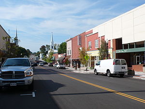
Christiansburg Downtown Historic District
Historic district in Virginia, United States
Distance: Approx. 27 meters
Latitude and longitude: 37.12972222,-80.40861111
Christiansburg Downtown Historic District is a national historic district located at Christiansburg, Montgomery County, Virginia. The district encompasses 32 contributing buildings, 1 contributing site, and 2 contributing objects in the central business district of Christiansburg. The district includes a variety of one-, two-, or three-story commercial or office buildings built primarily from the 1915-1950 period.
Weather in this IP's area
overcast clouds
-9 Celsius
-16 Celsius
-9 Celsius
-9 Celsius
1023 hPa
88 %
1023 hPa
939 hPa
10000 meters
4.7 m/s
11.34 m/s
305 degree
92 %


