Country:
 USA
USARegion:
City:
Latitude and Longitude:
Time Zone:
Postal Code:
IP information under different IP Channel
ip-api
Country
Region
City
ASN
Time Zone
ISP
Blacklist
Proxy
Latitude
Longitude
Postal
Route
IPinfo
Country
Region
City
ASN
Time Zone
ISP
Blacklist
Proxy
Latitude
Longitude
Postal
Route
MaxMind
Country
Region
City
ASN
Time Zone
ISP
Blacklist
Proxy
Latitude
Longitude
Postal
Route
Luminati
Country
USRegion
nh
City
manchester
ASN
Time Zone
America/New_York
ISP
TVC-AS1
Latitude
Longitude
Postal
db-ip
Country
Region
City
ASN
Time Zone
ISP
Blacklist
Proxy
Latitude
Longitude
Postal
Route
ipdata
Country
Region
City
ASN
Time Zone
ISP
Blacklist
Proxy
Latitude
Longitude
Postal
Route
Popular places and events near this IP address

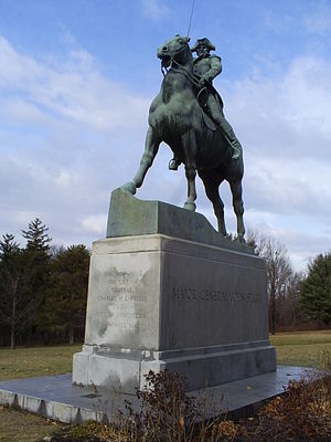
John Stark
18th century soldier from New Hampshire
Distance: Approx. 1182 meters
Latitude and longitude: 43.0142,-71.47095
Major-General John Stark (August 28, 1728 – May 8, 1822) was an American military officer who served during the French and Indian War and the Revolutionary War. He became known as the "Hero of Bennington" for his exemplary service at the Battle of Bennington in 1777.
Notre Dame College (New Hampshire)
Former Catholic college in the United States
Distance: Approx. 739 meters
Latitude and longitude: 43.01388889,-71.46527778
Notre Dame College was a Roman Catholic college located in Manchester, New Hampshire, United States, and affiliated with the Sisters of Holy Cross of Montreal, Quebec, Canada.

Zimmerman House (Manchester, New Hampshire)
Historic house in New Hampshire, United States
Distance: Approx. 1282 meters
Latitude and longitude: 43.02171944,-71.46287222
The Zimmerman House is a house museum in the North End neighborhood of Manchester, New Hampshire. Built in 1951, it is the first of two houses in New Hampshire designed by Frank Lloyd Wright (the other is the Toufic H. Kalil House, built in 1955 on the same street), and one of a modest number of Wright designs in the northeastern United States. The house was built for Dr.

Toufic H. Kalil House
House designed by Frank Lloyd Wright in New Hampshire, United States
Distance: Approx. 1362 meters
Latitude and longitude: 43.021639,-71.465353
The Toufic H. Kalil House is a house museum in the North End neighborhood of Manchester, New Hampshire, designed by Frank Lloyd Wright in 1955. The Usonian Automatic design of this house allowed Wright to meet the requirements of Dr. Toufic and Mildred Kalil, a Lebanese professional couple.

Frank Pierce Carpenter House
Historic house in New Hampshire, United States
Distance: Approx. 997 meters
Latitude and longitude: 43.00472222,-71.46583333
The Frank Pierce Carpenter House is a historic house at 1800 Elm Street on the north side of Manchester, New Hampshire. Built in 1891 for the president of the Amoskeag Paper Company, it is a fine local example of high-style Queen Anne architecture. It was listed on the National Register of Historic Places in 1994, and was home to the local chapter of the American Red Cross for approximately 71 years from the start of WWII. Today it is a privately owned office building protected by the Manchester Historic Association and known as the Carpenter Historic Building, LLC, which recently completed an award-winning historic renovation to the Carriage House onsite to bring back the stable and carriage entrance and former original living space for the caretaker now in use as office space.
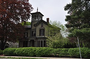
Thomas Russell Hubbard House
Historic house in New Hampshire, United States
Distance: Approx. 1423 meters
Latitude and longitude: 42.99833333,-71.45472222
The Thomas Russell Hubbard House is a historic house at 220 Myrtle Street in Manchester, New Hampshire. The 2½-story wood-frame house was built in 1867, by a farmer turned businessman and a prosperous owner of a factory and lumberyard, and is an exceptionally elaborate Italianate villa. It was listed on the National Register of Historic Places in 1988.

Smyth Tower
United States historic place
Distance: Approx. 1241 meters
Latitude and longitude: 43.01222222,-71.44194444
The Smyth Tower is a folly located on the grounds of the Manchester VA Medical Center at 718 Smyth Road in Manchester, New Hampshire. The fieldstone tower was built in 1888 by Frederick Smyth, and is the only surviving architectural structure related to his life. Smyth served as Governor of New Hampshire in 1865-67, and was an active promoter of veterans' issues in the post-Civil War period.
Stark Park
United States historic place
Distance: Approx. 1080 meters
Latitude and longitude: 43.01446,-71.4695
Stark Park is a city park located on the north side of Manchester, New Hampshire. It is a 30-acre (12 ha) parcel of land between River Road and the Merrimack River, which was once part of the larger farm property of American Revolutionary War hero John Stark. It was listed on the U.S. National Register of Historic Places in 2006, and the New Hampshire State Register of Historic Places in 2010.

Gen. John Stark House
Historic house in New Hampshire, United States
Distance: Approx. 833 meters
Latitude and longitude: 43.00833333,-71.46666667
The Gen. John Stark House is a historic house museum at 2000 Elm Street in Manchester, New Hampshire. The house, a single-story Cape style farmhouse, was built in 1736 by Archibald Stark.

William Parker Straw House
Historic house in New Hampshire, United States
Distance: Approx. 1068 meters
Latitude and longitude: 43.00722222,-71.46916667
The William Parker Straw House is a historic house at 282 North River Road in Manchester, New Hampshire. It was built in 1923 for William Parker Straw, a leading executive of the Amoskeag Manufacturing Company and president of the Amoskeag Bank, and is the city's finest example of Tudor Revival architecture. It was listed on the National Register of Historic Places in 1987.

Roger Sullivan House
Historic house in New Hampshire, United States
Distance: Approx. 1414 meters
Latitude and longitude: 42.99833333,-71.45833333
The Roger Sullivan House is a historic house at 168 Walnut Street in Manchester, New Hampshire. Built in 1892, it is the only known example of residential Queen Anne architecture by local architect William M. Butterfield, and is one of the city's finest examples of the style. It was listed on the National Register of Historic Places in 2004.
Sullivan House (Manchester, New Hampshire)
Historic house in New Hampshire, United States
Distance: Approx. 1204 meters
Latitude and longitude: 43.0211,-71.4624
The Sullivan House is a historic house at 1330 Union Street in Manchester, New Hampshire. Built in 1932–1933, it is an example of “Little House” architecture. It was added to the National Register of Historic Places in July 2023.
Weather in this IP's area
scattered clouds
13 Celsius
12 Celsius
12 Celsius
14 Celsius
1009 hPa
94 %
1009 hPa
999 hPa
10000 meters
2.06 m/s
230 degree
40 %
06:18:29
19:08:33