Country:
Region:
City:
Latitude and Longitude:
Time Zone:
Postal Code:
IP information under different IP Channel
ip-api
Country
Region
City
ASN
Time Zone
ISP
Blacklist
Proxy
Latitude
Longitude
Postal
Route
Luminati
Country
ASN
Time Zone
America/Toronto
ISP
ASN-WIBAND-1
Latitude
Longitude
Postal
IPinfo
Country
Region
City
ASN
Time Zone
ISP
Blacklist
Proxy
Latitude
Longitude
Postal
Route
db-ip
Country
Region
City
ASN
Time Zone
ISP
Blacklist
Proxy
Latitude
Longitude
Postal
Route
ipdata
Country
Region
City
ASN
Time Zone
ISP
Blacklist
Proxy
Latitude
Longitude
Postal
Route
Popular places and events near this IP address

George Massey Tunnel
Tunnel beneath the Fraser River in British Columbia
Distance: Approx. 2039 meters
Latitude and longitude: 49.121663,-123.075628
The George Massey Tunnel (often referred to as the Massey Tunnel) is a highway traffic tunnel in the Metro Vancouver region of southwestern British Columbia carrying Highway 99 beneath the south arm of the Fraser River. It is located approximately 20 km (12.4 mi) south of the city centre of Vancouver, British Columbia, and approximately 30 km (18.6 mi) north of the Canada–United States border at Blaine, Washington. Construction, costing approximately $16.6 million in 1959 ($140 million in 2017), began on the tunnel in March 1957, and it was opened to traffic on May 23, 1959 as the Deas Island Tunnel.

McRoberts Secondary School
High school in Richmond, British Columbia, Canada
Distance: Approx. 2240 meters
Latitude and longitude: 49.14027778,-123.126125
Hugh McRoberts Secondary School, officially École Secondaire Hugh McRoberts Secondary School, is a Canadian public school in Richmond, British Columbia and is a part of School District 38 Richmond. It is one of the two schools in Richmond that offer the French Immersion Secondary School program (the other being McMath). McRoberts is situated at Garden City Road and Williams Road.

Deas Island
Peninsula in British Columbia, Canada
Distance: Approx. 2800 meters
Latitude and longitude: 49.121,-123.065
Deas Island is a peninsula in the south arm of the Fraser River between Delta, British Columbia and Richmond, British Columbia, Canada. It is home to a regional park approximately 300 acres (120 ha) in size; and has three historic buildings: Burrvilla, a stately Victorian home; Inverholme, a one-room schoolhouse; and the Delta Agricultural Hall. Between 1895 and the 1940s, the peninsula had a small Greek settlement with a population of about 80 at its peak.

Matthew McNair Secondary School
High school in Richmond, British Columbia, Canada
Distance: Approx. 1805 meters
Latitude and longitude: 49.14238,-123.11285
Matthew McNair Secondary School is a public high school in Richmond, British Columbia and is part of School District 38 Richmond. Matthew McNair is one of the semester-style schools in Richmond. Its feeder schools include Hamilton Elementary, Walter Lee Elementary, Kingswood Elementary, Thomas Kidd Elementary, Woodward Elementary, and Morris Elementary.

Robert Cecil Palmer Secondary School
Secondary school in Richmond, British Columbia, Canada
Distance: Approx. 3530 meters
Latitude and longitude: 49.15404,-123.12921
Robert Cecil Palmer Secondary School, (commonly, R.C. Palmer Secondary School, RCPSS, RCP, and Palmer Secondary School) is a public, co-educational secondary school situated in Richmond, British Columbia, Canada which educates students in grades 8–12. Palmer Secondary School is one of the many schools under the Richmond School District. It is the only school in Richmond to offer the Pre-AP Incentive Program, the ACE-IT plumbing program and, previously, the Palmer Hockey Academy.

Fantasy Gardens
Former amusement park in Richmond, British Columbia, Canada
Distance: Approx. 1192 meters
Latitude and longitude: 49.13527778,-123.09027778
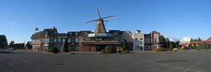
Fantasy Gardens, also known as Fantasy Garden World, was a former amusement park in Richmond, British Columbia that was located at the corner of Steveston Highway and No. 5 Road. The park was called Fantasy Gardens because it was surrounded by a series of stone buildings that were designed to resemble structures built during the Middle Ages.

Finn Slough
Distance: Approx. 1916 meters
Latitude and longitude: 49.11305556,-123.11555556
Finn Slough is a tiny Fraser River fishing community, sometimes referred to as Gilmore or Tiffin Slough. It is located at the south end of No. 4 Road in the Gilmore area of Richmond, British Columbia, Canada.

Ling Yen Mountain Temple
Buddhist monastery in British Columbia, Canada
Distance: Approx. 1608 meters
Latitude and longitude: 49.14035,-123.09108
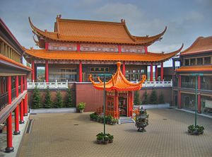
The Lingyen Mountain Temple (Chinese: 靈巖山寺; pinyin: líng yán shān sì) in Richmond, British Columbia, Canada is a Buddhist monastery, designed by Pacific Rim Architecture in the Chinese palatial style and completed in 1996. The temple has about 10,000 members in Greater Vancouver and several dozen resident monastics.

International Buddhist Temple
Chinese Buddhist temple in Richmond, British Columbia, Canada
Distance: Approx. 1671 meters
Latitude and longitude: 49.1332,-123.1234
The International Buddhist Temple (Chinese: 觀音寺; pinyin: Guān Yīn Sì; Guan Yin Temple) is located in Richmond, British Columbia, Canada. It is a Chinese Buddhist temple run by the International Buddhist Society. While the Society officially practices Mahayana Buddhism, the temple is open to Theravada Buddhist affiliates and visitors, as well as visitors of all religious and unique cultural backgrounds.
Thrangu Monastery (Canada)
Monastery in Richmond, British Columbia, Canada
Distance: Approx. 3364 meters
Latitude and longitude: 49.15,-123.13333333
Thrangu Monastery, Canada's first traditional Tibetan Buddhist monastery, was officially opened in Richmond, British Columbia, on July 25, 2010, by the Very Venerable Khenchen Thrangu Rinpoche, the worldwide leader of Thrangu Monasteries. Thrangu Rinpoche is a prominent tulku (reincarnate lama) in the Kagyu school of Tibetan Buddhism, the ninth reincarnation in his particular line. His full name and title is the Very Venerable Ninth Khenchen Thrangu Tulku, Karma Lodrö Lungrik Maway Senge.
Az-Zahraa Islamic Academy
Independent school in Richmond, BC, Canada
Distance: Approx. 2684 meters
Latitude and longitude: 49.15083333,-123.09111111
Az-Zahraa Islamic Academy (informally referred to as AZIA) is an independent Pre-school through Grade 7 school in Richmond, BC.

Ladner Ferry
Distance: Approx. 1601 meters
Latitude and longitude: 49.1175,-123.08666667
The Ladner Ferry was a crossing of the south arm of the Fraser River in Metro Vancouver, linking Ladner with Richmond. It operated from 1913 until 1959, when it was replaced by the George Massey Tunnel.
Weather in this IP's area
overcast clouds
10 Celsius
9 Celsius
9 Celsius
11 Celsius
1026 hPa
76 %
1026 hPa
1026 hPa
10000 meters
2.68 m/s
290 degree
100 %
09:07:23
18:44:40