Country:
 Canada
Region:
City:
Latitude and Longitude:
Time Zone:
Postal Code:
IP information under different IP Channel
ip-api
Country
Region
City
ASN
Time Zone
ISP
Blacklist
Proxy
Latitude
Longitude
Postal
Route
IPinfo
Country
Region
City
ASN
Time Zone
ISP
Blacklist
Proxy
Latitude
Longitude
Postal
Route
MaxMind
Country
Region
City
ASN
Time Zone
ISP
Blacklist
Proxy
Latitude
Longitude
Postal
Route
Luminati
Country
CAASN
Time Zone
America/Toronto
ISP
ASN-WIBAND-1
Latitude
Longitude
Postal
db-ip
Country
Region
City
ASN
Time Zone
ISP
Blacklist
Proxy
Latitude
Longitude
Postal
Route
ipdata
Country
Region
City
ASN
Time Zone
ISP
Blacklist
Proxy
Latitude
Longitude
Postal
Route
Popular places and events near this IP address
Queensborough Bridge
Bridge in New Westminster, British Columbia, Canada
Distance: Approx. 3730 meters
Latitude and longitude: 49.196415,-122.947183
Queensborough Bridge is a highway bridge in New Westminster, British Columbia. It was built in 1960 by John Laing and Son (Canada) for the City of New Westminster and cost $4 million (equivalent to $37.5 million in 2022). The bridge spans the north arm of the Fraser River for road access from the main part of New Westminster to the suburb of Queensborough at the east end of Lulu Island, giving the bridge its name.

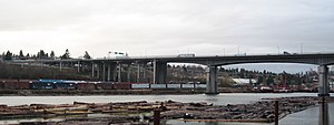
Alex Fraser Bridge
Bridge in Delta, BC
Distance: Approx. 1717 meters
Latitude and longitude: 49.1598,-122.9428
The Alex Fraser Bridge (also known as the Annacis Bridge) is a cable-stayed bridge over the Fraser River that connects Richmond and New Westminster with North Delta in Greater Vancouver, British Columbia. The bridge is named for Alex Fraser (1916 – 1989), a former British Columbia Minister of Transportation. The bridge was the longest cable-stayed bridge in the world when it opened on September 22, 1986, and was the longest in North America until the Arthur Ravenel Jr.
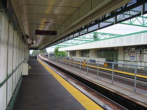
22nd Street station (SkyTrain)
Metro Vancouver SkyTrain station
Distance: Approx. 4063 meters
Latitude and longitude: 49.2,-122.94916667
22nd Street is an elevated station on the Expo Line of Metro Vancouver's SkyTrain rapid transit system. It is located on 7th Avenue and 22nd Street in the Connaught Heights neighbourhood of New Westminster, British Columbia, Canada. Due to its proximity to the Queensborough interchange, where the Queensborough Bridge meets with Stewardson and Marine Ways, the station serves as a hub for regional bus routes.

Annacis Island
Island in British Columbia, Canada
Distance: Approx. 1127 meters
Latitude and longitude: 49.16666667,-122.94972222
Annacis Island is a narrow island under the jurisdiction of City of Delta in Lower Mainland, British Columbia, located just downstream of the south arm of the Fraser River bifurcation between Lulu Island to the north and the Delta peninsula to the south. The island is now mostly an industrial zone, and contains one of Metro Vancouver's secondary wastewater treatment plants, the Annacis Island Wastewater Treatment Plant. The island is also home to the British Columbia Institute of Technology's Annacis Island campus.

Annacis Island Swing Bridge
Bridge in New Westminster, Delta
Distance: Approx. 3363 meters
Latitude and longitude: 49.18636,-122.932312
The Annacis Island Swing Bridge, built in 1986, is a road and rail swing bridge over the Annacis Channel of the Fraser River in the Lower Mainland of British Columbia, Canada. The bridge connects the community of Queensborough, part of New Westminster on Lulu Island, to Annacis Island in Delta. It replaced the Derwent Way Bridge built in 1955 at the same location.

Queensborough, New Westminster
Neighbourhood of New Westminster in Lower Mainland, British Columbia, Canada
Distance: Approx. 3078 meters
Latitude and longitude: 49.18333333,-122.93333333
Queensborough is a neighbourhood in the city of New Westminster, British Columbia, Canada. It is on the eastern tip of Lulu Island on the Fraser River. At the north end of Queensborough is a new development called Port Royal.

Sands Secondary School
High school in Delta, British Columbia, Canada
Distance: Approx. 3437 meters
Latitude and longitude: 49.15165,-122.922437
Sands Secondary is a public high school in Delta, British Columbia part of School District 37 Delta.

CNR Bridge
Bridge in Burnaby-Richmond
Distance: Approx. 2608 meters
Latitude and longitude: 49.182903,-122.988113
Opened in 1931, the Canadian National Railway (CNR) steel truss swing span railway bridge over the north arm of the Fraser River in Metro Vancouver links Burnaby with Richmond and the south arm Vancouver Fraser Port Authority facilities on Lulu Island. The Canadian Northern Railway (CNoR) had planned to lay track from the north end of the New Westminster Bridge and cross the Fraser at the 1931 location. However, when the CNoR opened the Lulu Island branch line in 1917, it connected with the British Columbia Electric Railway (BCER) Queensborough terminus.
CISL (AM)
Radio station in Richmond, British Columbia
Distance: Approx. 3744 meters
Latitude and longitude: 49.16638889,-123.01638889
CISL (650 kHz) is a commercial AM radio station licensed to Richmond, British Columbia, and serving the Greater Vancouver radio market. It is owned by Rogers Radio, a division of Rogers Sports & Media and airs a sports format branded as Sportsnet 650. It is the flagship station of the Vancouver Giants, Vancouver Canucks, Abbotsford Canucks, and is the Vancouver affiliate of the Toronto Blue Jays and Seattle Mariners.
Sungod Recreation Centre
Distance: Approx. 4256 meters
Latitude and longitude: 49.14542,-122.91479
Sungod Recreation Centre is a recreation centre located in Delta, British Columbia. The facility contains four pools, a swirl pool, a sauna, a steam room, a weight room, an aerobic studio, and an ice rink. It also hosts swimming lessons including kids, teens, and lifeguard courses.

Big Bend, Burnaby
Neighbourhood in Burnaby, British Columbia, Canada
Distance: Approx. 3812 meters
Latitude and longitude: 49.198,-122.979
Big Bend is the southernmost neighbourhood in Burnaby, British Columbia, Canada, located on the watershed of the Fraser River. The neighbourhood owes its name to the large bend that the river forms on its North Arm. Big Bend comprises all of Burnaby south of Marine Drive.
Don Island
Island in British Columbia
Distance: Approx. 1949 meters
Latitude and longitude: 49.16021,-122.99075
Don Island is a small uninhabited island in the Fraser River within metropolitan Vancouver, British Columbia, located just east of Annacis Island. While currently devoid of any permanent settlement, between 1901 and the 1940s Don Island and its neighbor Lion Island were home to over 400 Japanese Canadians, who were mainly employed at the Ewen Cannery, which was one of the largest salmon canneries in British Columbia. They were known to the Japanese Canadians as Oikawa-Jima and Sato-Jima.
Weather in this IP's area
broken clouds
13 Celsius
13 Celsius
12 Celsius
14 Celsius
1016 hPa
90 %
1016 hPa
1016 hPa
10000 meters
3.6 m/s
300 degree
75 %
06:54:55
19:16:02