Country:
 Canada
Region:
City:
Latitude and Longitude:
Time Zone:
Postal Code:
IP information under different IP Channel
ip-api
Country
Region
City
ASN
Time Zone
ISP
Blacklist
Proxy
Latitude
Longitude
Postal
Route
IPinfo
Country
Region
City
ASN
Time Zone
ISP
Blacklist
Proxy
Latitude
Longitude
Postal
Route
MaxMind
Country
Region
City
ASN
Time Zone
ISP
Blacklist
Proxy
Latitude
Longitude
Postal
Route
Luminati
Country
CAASN
Time Zone
America/Toronto
ISP
ASN-WIBAND-1
Latitude
Longitude
Postal
db-ip
Country
Region
City
ASN
Time Zone
ISP
Blacklist
Proxy
Latitude
Longitude
Postal
Route
ipdata
Country
Region
City
ASN
Time Zone
ISP
Blacklist
Proxy
Latitude
Longitude
Postal
Route
Popular places and events near this IP address
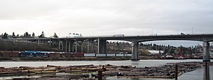
Queensborough Bridge
Bridge in New Westminster, British Columbia, Canada
Distance: Approx. 2751 meters
Latitude and longitude: 49.196415,-122.947183
Queensborough Bridge is a highway bridge in New Westminster, British Columbia. It was built in 1960 by John Laing and Son (Canada) for the City of New Westminster and cost $4 million (equivalent to $37.5 million in 2022). The bridge spans the north arm of the Fraser River for road access from the main part of New Westminster to the suburb of Queensborough at the east end of Lulu Island, giving the bridge its name.

Alex Fraser Bridge
Bridge in Delta, BC
Distance: Approx. 1873 meters
Latitude and longitude: 49.1598,-122.9428
The Alex Fraser Bridge (also known as the Annacis Bridge) is a cable-stayed bridge over the Fraser River that connects Richmond and New Westminster with North Delta in Greater Vancouver, British Columbia. The bridge is named for Alex Fraser (1916 – 1989), a former British Columbia Minister of Transportation. The bridge was the longest cable-stayed bridge in the world when it opened on September 22, 1986, and was the longest in North America until the Arthur Ravenel Jr.

North Delta
Neighbourhood of Delta in Lower Mainland, British Columbia, Canada
Distance: Approx. 3115 meters
Latitude and longitude: 49.15444444,-122.9
North Delta (founded as Annieville) is a largely middle-class commuter town situated in the Lower Mainland, of British Columbia, Canada. The community is the most populous of the three communities (North Delta, Ladner, and Tsawwassen) that make up the City of Delta. North Delta is home to numerous parks and recreational opportunities.

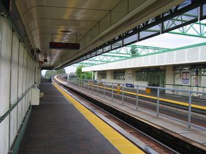
New Westminster station
Metro Vancouver SkyTrain station
Distance: Approx. 3253 meters
Latitude and longitude: 49.201354,-122.912716
New Westminster is an elevated station on the Expo Line of Metro Vancouver's SkyTrain rapid transit system. The station is located at the intersection of Columbia Street and 8th Street in New Westminster, British Columbia. In 2012, the station was incorporated into the Shops at New West complex, making it the first train station in Canada to have a direct connection to a shopping centre at the platform level.
22nd Street station (SkyTrain)
Metro Vancouver SkyTrain station
Distance: Approx. 3173 meters
Latitude and longitude: 49.2,-122.94916667
22nd Street is an elevated station on the Expo Line of Metro Vancouver's SkyTrain rapid transit system. It is located on 7th Avenue and 22nd Street in the Connaught Heights neighbourhood of New Westminster, British Columbia, Canada. Due to its proximity to the Queensborough interchange, where the Queensborough Bridge meets with Stewardson and Marine Ways, the station serves as a hub for regional bus routes.

Annacis Island
Island in British Columbia, Canada
Distance: Approx. 1674 meters
Latitude and longitude: 49.16666667,-122.94972222
Annacis Island is a narrow island under the jurisdiction of City of Delta in Lower Mainland, British Columbia, located just downstream of the south arm of the Fraser River bifurcation between Lulu Island to the north and the Delta peninsula to the south. The island is now mostly an industrial zone, and contains one of Metro Vancouver's secondary wastewater treatment plants, the Annacis Island Wastewater Treatment Plant. The island is also home to the British Columbia Institute of Technology's Annacis Island campus.

Annacis Island Swing Bridge
Bridge in New Westminster, Delta
Distance: Approx. 1342 meters
Latitude and longitude: 49.18636,-122.932312
The Annacis Island Swing Bridge, built in 1986, is a road and rail swing bridge over the Annacis Channel of the Fraser River in the Lower Mainland of British Columbia, Canada. The bridge connects the community of Queensborough, part of New Westminster on Lulu Island, to Annacis Island in Delta. It replaced the Derwent Way Bridge built in 1955 at the same location.

Queensborough, New Westminster
Neighbourhood of New Westminster in Lower Mainland, British Columbia, Canada
Distance: Approx. 1024 meters
Latitude and longitude: 49.18333333,-122.93333333
Queensborough is a neighbourhood in the city of New Westminster, British Columbia, Canada. It is on the eastern tip of Lulu Island on the Fraser River. At the north end of Queensborough is a new development called Port Royal.

Sands Secondary School
High school in Delta, British Columbia, Canada
Distance: Approx. 2592 meters
Latitude and longitude: 49.15165,-122.922437
Sands Secondary is a public high school in Delta, British Columbia part of School District 37 Delta.

North Delta Secondary School
High school in Delta, British Columbia, Canada
Distance: Approx. 2958 meters
Latitude and longitude: 49.15327,-122.90536
North Delta Secondary is a public high school in Delta, British Columbia, Canada. It is part of School District 37 Delta. North Delta Secondary School, when it was opened in 1957, was originally a secondary school designed to accommodate approximately 550 students.

Poplar Island (British Columbia)
Uninhabited island in British Columbia, Canada
Distance: Approx. 2860 meters
Latitude and longitude: 49.2,-122.93333333
Poplar Island is an uninhabited island located at the east end of the northern arm of the Fraser River in the City of New Westminster, British Columbia. It is the last large undiked island in the Fraser River's North Arm.
VirtualSchoolBC
Distance: Approx. 3031 meters
Latitude and longitude: 49.2007,-122.9192
VirtualSchoolBC is an online school offering free secondary school courses to British Columbia residents. It is headquartered in Westminster, British Columbia, Canada. VirtualSchoolBC is a public school within School District 40 New Westminster.
Weather in this IP's area
broken clouds
13 Celsius
13 Celsius
12 Celsius
15 Celsius
1016 hPa
98 %
1016 hPa
1015 hPa
10000 meters
3.6 m/s
300 degree
75 %
06:54:47
19:15:54