Country:
 USA
USARegion:
City:
Latitude and Longitude:
Time Zone:
Postal Code:
IP information under different IP Channel
ip-api
Country
Region
City
ASN
Time Zone
ISP
Blacklist
Proxy
Latitude
Longitude
Postal
Route
IPinfo
Country
Region
City
ASN
Time Zone
ISP
Blacklist
Proxy
Latitude
Longitude
Postal
Route
MaxMind
Country
Region
City
ASN
Time Zone
ISP
Blacklist
Proxy
Latitude
Longitude
Postal
Route
Luminati
Country
USRegion
ut
City
saltlakecity
ASN
Time Zone
America/Denver
ISP
1WIRE-FIBER
Latitude
Longitude
Postal
db-ip
Country
Region
City
ASN
Time Zone
ISP
Blacklist
Proxy
Latitude
Longitude
Postal
Route
ipdata
Country
Region
City
ASN
Time Zone
ISP
Blacklist
Proxy
Latitude
Longitude
Postal
Route
Popular places and events near this IP address

South Salt Lake, Utah
City in Utah, United States
Distance: Approx. 726 meters
Latitude and longitude: 40.70777778,-111.88916667
South Salt Lake is a city in Salt Lake County, Utah, United States and is part of the Salt Lake City Metropolitan Statistical Area. The population was 23,617 at the 2010 census.
Granite School District
School district in Utah, United States
Distance: Approx. 233 meters
Latitude and longitude: 40.71638889,-111.88916667
The Granite School District is a public school district spread across central Salt Lake County, Utah, serving West Valley City, Millcreek, Taylorsville, South Salt Lake, and Holladay; Kearns and Magna Townships; and parts of West Jordan, Murray and Cottonwood Heights. About 67,000 students are enrolled in its programs ranging from kindergarten to twelfth grade. It operates 9 high schools, 15 junior high schools, 62 elementary schools, as well as several specialty schools.

Columbus Center
Distance: Approx. 1014 meters
Latitude and longitude: 40.71555556,-111.8775
The Columbus School Building (aka the Columbus Center), one of South Salt Lake's most notable and unique buildings, currently serves as a community center. Located at 2531 South 400 East, the Columbus School building is not only a community landmark, but a vital gathering place as well. The grounds around the building resemble a plaza or garden type area landscaped with pathways, benches, statues, and various plants and trees.
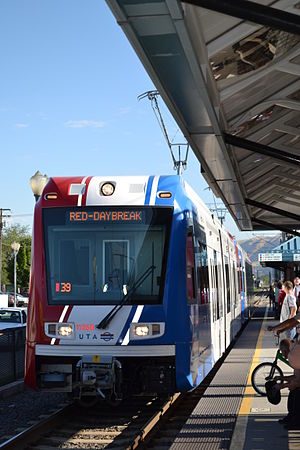
Central Pointe station
Distance: Approx. 1290 meters
Latitude and longitude: 40.7244,-111.8969
Central Pointe station is a light rail station in South Salt Lake, Utah, in the United States, served by all three lines of the Utah Transit Authority's (UTA) TRAX light rail system. In December 2013, the station also became the western terminus for the S Line (formerly known as Sugar House Streetcar).

Millcreek station
Distance: Approx. 1681 meters
Latitude and longitude: 40.699606,-111.894007
Millcreek station is a light rail station in South Salt Lake, Utah, United States serviced by the Blue Line and the Red Line of Utah Transit Authority's TRAX light rail system. The Blue Line provides service from Downtown Salt Lake City to Draper. The Red Line provides service from the University of Utah to the Daybreak community of South Jordan.
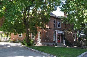
George M. Cannon House
Historic house in Salt Lake City, Utah, U.S.
Distance: Approx. 1756 meters
Latitude and longitude: 40.71944444,-111.86972222
The George M. Cannon House, built in 1890, is an historic Late Victorian mansion located at 720 East Ashton Avenue (2340 South) in the Forest Dale area of Salt Lake City, Utah. It was designed by noted Salt Lake architect John A. Headlund for George Mousley Cannon (December 25, 1861 – January 23, 1937), a member of the Cannon family, a prominent Intermountain West political family. In 1889 George M. Cannon had bought Forest Farm from the estate of Brigham Young and created the subdivision of Forest Dale and later the larger town of Forest Dale, which existed from 1902 until 1912, when it was reabsorbed into Salt Lake City.

Kearns-St. Ann's Orphanage
United States historic place
Distance: Approx. 1528 meters
Latitude and longitude: 40.725,-111.87805556
The Kearns-St. Ann's Orphanage, at 430 East 2100 South in South Salt Lake, Utah, was built in 1890. It was designed by architect Carl M. Neuhausen.

South Salt Lake City station
Distance: Approx. 883 meters
Latitude and longitude: 40.72222222,-111.89
South Salt Lake City is a streetcar stop in South Salt Lake, Utah, in the United States, served by Utah Transit Authority's (UTA) S Line (previously known as the Sugar House Streetcar). The S Line provides service from the Sugar House neighborhood of Salt Lake City to the city of South Salt Lake (where it connects with UTA's TRAX light rail system).

300 East station
Distance: Approx. 1070 meters
Latitude and longitude: 40.72222222,-111.88222222
300 East is a streetcar stop in South Salt Lake, Utah, served by Utah Transit Authority's (UTA) S Line (previously known as the Sugar House Streetcar). The S Line provides service from the Sugar House neighborhood of Salt Lake City to the city of South Salt Lake (where it connects with UTA's TRAX light rail system).

500 East station
Distance: Approx. 1372 meters
Latitude and longitude: 40.72222222,-111.87694444
500 East is a streetcar stop in South Salt Lake, Utah, served by Utah Transit Authority's (UTA) S Line (previously known as the Sugar House Streetcar). The S Line provides service from the Sugar House neighborhood of Salt Lake City to the city of South Salt Lake (where it connects with UTA's TRAX light rail system).

700 East station
Distance: Approx. 1769 meters
Latitude and longitude: 40.72277778,-111.87166667
700 East is a streetcar stop in the Sugar House neighborhood of Salt Lake City, Utah, in the United States, served by Utah Transit Authority's (UTA) S Line (previously known as the Sugar House Streetcar). The S Line provides service from Sugar House to the city of South Salt Lake (where it connects with UTA's TRAX light rail system).
Kearns-Saint Ann Catholic School
Private, coeducational school in South Salt Lake, Utah, United States
Distance: Approx. 1472 meters
Latitude and longitude: 40.7248,-111.8788
Kearns-Saint Ann School is a Catholic school for preschool to eighth grade students, located in South Salt Lake, Utah. Founded as St. Ann's Orphanage in 1891, it became a parochial school in 1955.
Weather in this IP's area
broken clouds
26 Celsius
26 Celsius
24 Celsius
27 Celsius
1013 hPa
30 %
1013 hPa
877 hPa
10000 meters
4.63 m/s
160 degree
75 %
07:02:05
19:48:20