208.81.80.199 - IP Lookup: Free IP Address Lookup, Postal Code Lookup, IP Location Lookup, IP ASN, Public IP
Country:
 USA
USARegion:
City:
Location:
Time Zone:
Postal Code:
ISP:
ASN:
language:
User-Agent:
Proxy IP:
Blacklist:
IP information under different IP Channel
ip-api
Country
Region
City
ASN
Time Zone
ISP
Blacklist
Proxy
Latitude
Longitude
Postal
Route
db-ip
Country
Region
City
ASN
Time Zone
ISP
Blacklist
Proxy
Latitude
Longitude
Postal
Route
IPinfo
Country
Region
City
ASN
Time Zone
ISP
Blacklist
Proxy
Latitude
Longitude
Postal
Route
IP2Location
208.81.80.199Country
usRegion
iowa
City
waterloo
Time Zone
America/Chicago
ISP
Language
User-Agent
Latitude
Longitude
Postal
ipdata
Country
Region
City
ASN
Time Zone
ISP
Blacklist
Proxy
Latitude
Longitude
Postal
Route
Popular places and events near this IP address

East High School (Waterloo, Iowa)
Public secondary school in Waterloo, Iowa, United States
Distance: Approx. 5472 meters
Latitude and longitude: 42.502,-92.329
Waterloo East High School in Waterloo, Iowa, United States is a public high school consisting of approximately 1000 students in grades 9–12. It is a part of the Waterloo Community School District.

East Waterloo Township, Black Hawk County, Iowa
Township in Iowa, United States
Distance: Approx. 1887 meters
Latitude and longitude: 42.51111111,-92.26555556
East Waterloo Township is one of seventeen rural townships in Black Hawk County, Iowa, United States. As of the 2000 census, its population was 5936.

KBBG
African American community radio station in Waterloo, Iowa
Distance: Approx. 4534 meters
Latitude and longitude: 42.5125,-92.32333333
KBBG (88.1 FM) is a non-commercial educational radio station licensed to serve the community of Waterloo, Iowa. KBBG is owned by Afro American Community Broadcasting, Inc and is organized as a 501(C)3 tax-exempt organization. Jimmie Porter founded the corporation in 1977 with a group of 16 other Waterloo residents.
Dewar, Iowa
Unincorporated town in Iowa, United States
Distance: Approx. 4331 meters
Latitude and longitude: 42.52555556,-92.21916667
Dewar is an unincorporated town in eastern Black Hawk County, Iowa, United States. It lies northeast of the city of Waterloo, the county seat of Black Hawk County. Its elevation is 889 feet (271 m).
Walnut Street Baptist Church (Waterloo, Iowa)
United States historic place
Distance: Approx. 5793 meters
Latitude and longitude: 42.5025,-92.33388889
Walnut Street Baptist Church is a church building in downtown Waterloo, Iowa, United States. It has also been known as Faith Temple Baptist Church. Built in 1908, it was designed for its triangular lot by Waterloo architect Clinton P. Shockley.

Rath Packing Company Administration Building
United States historic place
Distance: Approx. 5736 meters
Latitude and longitude: 42.4925,-92.32333333
The Rath Packing Company Administration Building, also known as Adams Store Inc., is a historic Late Gothic Revival building in Waterloo, Iowa. It is a surviving remnant of what was the largest meat-packing plant in the United States in 1941. The plant started in 1891 with hogs, and was "massive".

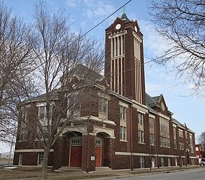
Roosevelt Elementary School (Waterloo, Iowa)
United States historic place
Distance: Approx. 5353 meters
Latitude and longitude: 42.51888889,-92.33611111
The Roosevelt Elementary School at 200 E. Arlington St. in Waterloo, Iowa was built during 1921-22 and extended in 1954. It was a Late Gothic Revival architecture work by Waterloo architect Mortimer B. Cleveland.

Dunsmore House
Historic house in Iowa, United States
Distance: Approx. 5597 meters
Latitude and longitude: 42.51325,-92.33736111
The Dunsmore House is a historic building in Waterloo, Iowa, United States. Thomas Chadwick, a master stonemason originally from England, built this house from native rusticated limestone about 1866. It is one of the earliest extant houses, and the only house made of limestone block still extant in the Waterloo-Cedar Falls area.
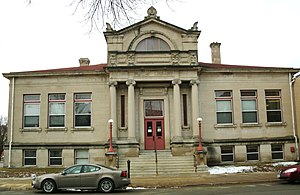
Waterloo Public Library-East Side Branch
United States historic place
Distance: Approx. 5946 meters
Latitude and longitude: 42.49916667,-92.33341667
The Waterloo Public Library-East Side Branch is a historic building located in Waterloo, Iowa, United States. The public library was established here in 1896. It operated out of two rented rooms, one on the east side of the Cedar River and other on the west side.

Grace Methodist Episcopal Church (Waterloo, Iowa)
United States historic place
Distance: Approx. 5668 meters
Latitude and longitude: 42.50097222,-92.33094444
Grace Methodist Episcopal Church, also known as Mount Moriah Missionary Baptist Church, is a historic building located in Waterloo, Iowa, United States. The congregation that built this building was organized in 1861 as First Methodist Episcopal Church. They built church buildings in 1865 at Lafayette and East Fifth Streets, and then at East Fourth and Mulberry Streets in 1877.

Highland Historic District (Waterloo, Iowa)
Historic district in Iowa, United States
Distance: Approx. 4446 meters
Latitude and longitude: 42.50027778,-92.31166667
The Highland Historic District is a nationally recognized historic district located in Waterloo, Iowa, United States. It was listed on the National Register of Historic Places in 1984. Because of industrial growth the city's population doubled between 1890 and 1900, and then again between 1900 and 1910.
Walnut Street Historic District (Waterloo, Iowa)
Historic district in Iowa, United States
Distance: Approx. 5818 meters
Latitude and longitude: 42.50277778,-92.33444444
The Walnut Street Historic District is a nationally recognized historic district located in Waterloo, Iowa, United States. It was listed on the National Register of Historic Places (NRHP) in 2019. At the time of its nomination the district consisted of 111 resources, including 91 contributing buildings and 20 non-contributing buildings.
Weather in this IP's area
haze
-13 Celsius
-20 Celsius
-14 Celsius
-12 Celsius
1021 hPa
81 %
1021 hPa
984 hPa
6437 meters
8.23 m/s
340 degree
100 %