Country:
Region:
City:
Latitude and Longitude:
Time Zone:
Postal Code:
IP information under different IP Channel
ip-api
Country
Region
City
ASN
Time Zone
ISP
Blacklist
Proxy
Latitude
Longitude
Postal
Route
Luminati
Country
ASN
Time Zone
America/Puerto_Rico
ISP
OSNET
Latitude
Longitude
Postal
IPinfo
Country
Region
City
ASN
Time Zone
ISP
Blacklist
Proxy
Latitude
Longitude
Postal
Route
db-ip
Country
Region
City
ASN
Time Zone
ISP
Blacklist
Proxy
Latitude
Longitude
Postal
Route
ipdata
Country
Region
City
ASN
Time Zone
ISP
Blacklist
Proxy
Latitude
Longitude
Postal
Route
Popular places and events near this IP address

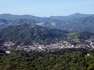
Utuado, Puerto Rico
Town and municipality in Puerto Rico
Distance: Approx. 2460 meters
Latitude and longitude: 18.26555556,-66.70055556
Utuado (Spanish pronunciation: [uˈtwaðo]) is a town and municipality of Puerto Rico located in the central mountainous region of the island known as the Cordillera Central. It is located north of Adjuntas and Ponce; south of Hatillo and Arecibo; east of Lares; and west of Ciales and Jayuya. It is the third-largest municipality in land area in Puerto Rico (after Arecibo and Ponce).

University of Puerto Rico at Utuado
Public college in Utuado, Puerto Rico
Distance: Approx. 1973 meters
Latitude and longitude: 18.25416183,-66.72098644
The University of Puerto Rico at Utuado (UPRU or UPR-Utuado) is a public college in Utuado, Puerto Rico. Founded in 1979, it is the youngest of the campuses that compose the University of Puerto Rico system. UPR-Utuado is also known by its previous name Colegio Regional de la Montaña (Regional College of the Mountain) and its acronym "CORMO".
Viví River
River of Puerto Rico
Distance: Approx. 2594 meters
Latitude and longitude: 18.2671761,-66.7082298
The Viví River (Spanish: Río Viví) is a river in Puerto Rico that runs through the town of Utuado and Adjuntas, Puerto Rico. It is about 11 miles long. The town was to begin work on a bridge that goes over the Viví River in 2019, since its destruction on September 20, 2017 by Hurricane Maria.

WUPR
Radio station in Utuado, Puerto Rico
Distance: Approx. 2681 meters
Latitude and longitude: 18.26777778,-66.70972222
WUPR (1530 AM) is a radio station broadcasting a Spanish news/talk format. Licensed to Utuado, Puerto Rico, it serves the Puerto Rico area.
Guaonica River
River of Puerto Rico
Distance: Approx. 2420 meters
Latitude and longitude: 18.256621,-66.724341
The Guaonica River (Spanish: Río Guaonica) is a river of Utuado, Puerto Rico.

Pellejas River
River of Puerto Rico
Distance: Approx. 1988 meters
Latitude and longitude: 18.2302333,-66.7176743
The Pellejas River (Spanish: Río Pellejas) is a river of Utuado, Puerto Rico. Pellejas is a tributary to the Río Grande de Arecibo river.
Roncador River
River of Puerto Rico
Distance: Approx. 3303 meters
Latitude and longitude: 18.2538433,-66.7351746
The Roncador River is a river of Puerto Rico.

Viví Abajo
Barrio of Utuado, Puerto Rico
Distance: Approx. 2957 meters
Latitude and longitude: 18.259344,-66.682867
Viví Abajo is a barrio in the municipality of Utuado, Puerto Rico. Its population in 2010 was 3,143.

Utuado barrio-pueblo
Historical and administrative center (seat) of Utuado, Puerto Rico
Distance: Approx. 2445 meters
Latitude and longitude: 18.265954,-66.706242
Utuado barrio-pueblo is a barrio and the administrative center (seat) of Utuado, a municipality of Puerto Rico. Its population in 2010 was 5,856.

Pellejas, Adjuntas, Puerto Rico
Barrio in Puerto Rico
Distance: Approx. 3570 meters
Latitude and longitude: 18.212137,-66.70952
Pellejas is a rural barrio in the municipality of Adjuntas, Puerto Rico. Its population in 2010 was 553.

Arenas, Utuado, Puerto Rico
Barrio of Puerto Rico
Distance: Approx. 486 meters
Latitude and longitude: 18.240029,-66.707603
Arenas is a barrio in the municipality of Utuado, Puerto Rico. Its population in 2010 was 1,860.

Church San Miguel Arcángel of Utuado
United States historic place
Distance: Approx. 2471 meters
Latitude and longitude: 18.2653105,-66.6991435
The Church of Saint Michael the Archangel of Utuado (Spanish: Iglesia San Miguel Arcángel de Utuado) is a historic Roman Catholic parish church located in Utuado Pueblo, the administrative and historic center of the municipality of Utuado, Puerto Rico. The church is listed in the Inventory of the Historic Churches of Puerto Rico, the Puerto Rico Register of Historic Sites and Zones and the United States National Register of Historic Places due to its architectural and historical significance. The church was designed in 1866 by Onofre Llorapart and built in stages between 1872 and 1878 in the main town square (plaza pública) of Utuado, on its east-facing block that it currently shares with the parish house (casa parroquial) and its adjacent Catholic school.
Weather in this IP's area
light rain
23 Celsius
24 Celsius
22 Celsius
25 Celsius
1014 hPa
95 %
1014 hPa
986 hPa
10000 meters
2.55 m/s
7.78 m/s
24 degree
100 %
06:34:34
17:49:30