208.81.207.34 - IP Lookup: Free IP Address Lookup, Postal Code Lookup, IP Location Lookup, IP ASN, Public IP
Country:
Region:
City:
Location:
Time Zone:
Postal Code:
IP information under different IP Channel
ip-api
Country
Region
City
ASN
Time Zone
ISP
Blacklist
Proxy
Latitude
Longitude
Postal
Route
Luminati
Country
Region
on
City
brampton
ASN
Time Zone
America/Toronto
ISP
COEXTRO-01
Latitude
Longitude
Postal
IPinfo
Country
Region
City
ASN
Time Zone
ISP
Blacklist
Proxy
Latitude
Longitude
Postal
Route
IP2Location
208.81.207.34Country
Region
ontario
City
mississauga
Time Zone
America/Toronto
ISP
Language
User-Agent
Latitude
Longitude
Postal
db-ip
Country
Region
City
ASN
Time Zone
ISP
Blacklist
Proxy
Latitude
Longitude
Postal
Route
ipdata
Country
Region
City
ASN
Time Zone
ISP
Blacklist
Proxy
Latitude
Longitude
Postal
Route
Popular places and events near this IP address
Paramount Fine Foods Centre
Arena in Mississauga, Ontario
Distance: Approx. 1434 meters
Latitude and longitude: 43.6323,-79.6535
The Paramount Fine Foods Centre, formerly the Hershey Centre, is a multi-purpose sports and entertainment complex located in Mississauga, Ontario, Canada. Its current name was adopted on July 1, 2018, following a new naming rights agreement with Mississauga-based restaurant chain Paramount Fine Foods.

Philip Pocock Catholic Secondary School
Catholic high school in Mississauga, Ontario, Canada
Distance: Approx. 962 meters
Latitude and longitude: 43.625,-79.626
Philip Pocock Catholic Secondary School (alternatively called as Philip Pocock, PPCSS, PP, Philip Pocock CSS, or Pocock) is a Roman Catholic high school in Mississauga, Ontario, Canada. It is operated by the Dufferin-Peel Catholic District School Board and has approximately 1,350 students. The school includes an Extended French Program as well as an Advanced Placement Program for Mathematics and the Sciences (Biology, Physics, Chemistry).
John Cabot Catholic Secondary School
Separate high school in Mississauga, Ontario, Canada
Distance: Approx. 2253 meters
Latitude and longitude: 43.6128,-79.6205
John Cabot Catholic Secondary School is located in Mississauga, Ontario, Canada. It is a separate Catholic high school within the Dufferin-Peel Catholic District School Board. The school mascot is the Colt.
CINA (AM)
Multicultural radio station in Mississauga, Ontario
Distance: Approx. 604 meters
Latitude and longitude: 43.62555556,-79.63111111
CINA (1650 kHz) is a commercial AM radio station, licensed to Mississauga, Ontario, Canada and serving the Greater Toronto area. It broadcasts a South-Asian format of talk, news and music shows. It is owned by Neeti Prakash Ray, who co-owns a sister station in Windsor, CINA-FM. By day, CINA is powered at 5,000 watts; however, to protect other stations from interference, at night it reduces power to 680 watts.
Baitul Hamd Mosque (Mississauga)
Mosque in Ontario, Canada
Distance: Approx. 851 meters
Latitude and longitude: 43.63722222,-79.63694444
The Baitul Hamd Mosque (Urdu: بیت الحمد, lit. 'House of Praise') is an Ahmadiyy mosque in Mississauga, Ontario, in Canada. The mosque is run by the Ahmadiyya Muslim Community Canada (AMJ). In 1999, the AMJ purchased the building from Trinity Club House.

Rockwood Village
Neighbourhood in Peel, Ontario, Canada
Distance: Approx. 2549 meters
Latitude and longitude: 43.62552778,-79.60497222
Rockwood Village is a neighbourhood in the eastern part of the City of Mississauga, Ontario, Canada, in the Regional Municipality of Peel. Its approximate boundaries are Eglinton Avenue in the north, Burnhamthorpe Road in the south, the Etobicoke Creek (the city limits of Mississauga) on the east and Dixie Road on the west. The Municipal Ward is Ward 3, the provincial riding is Mississauga East—Cooksville and the federal riding is Mississauga East—Cooksville.

Tahoe station
Distance: Approx. 2330 meters
Latitude and longitude: 43.63861111,-79.61
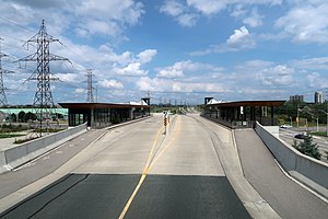
Tahoe is a bus rapid transit station on the Mississauga Transitway in Mississauga, Ontario, Canada. It is located along the east side of Eastgate Parkway on the south side of Tahoe Boulevard. Tahoe and Etobicoke Creek opened on 16 February 2016.

Dixie station (MiWay)
Bus station in Mississauga, Ontario
Distance: Approx. 1747 meters
Latitude and longitude: 43.63027778,-79.61444444
Dixie is a bus rapid transit station on the Mississauga Transitway in central Mississauga, Ontario, Canada. It is located on the west side of Dixie Road along the north side of Eastgate Parkway. The first four stations on the Transitway at Central Parkway, Cawthra, Tomken, and Dixie, opened on 17 November 2014.

Tomken station
Distance: Approx. 1339 meters
Latitude and longitude: 43.62166667,-79.62361111
Tomken is a bus rapid transit station on the Mississauga Transitway in central Mississauga, Ontario, Canada. It is located on the west side of Tomken Road along the north side of Eastgate Parkway. The first four stations on the Transitway at Central Parkway, Cawthra, Tomken and Dixie, opened on 17 November 2014.

Cawthra station
Bus rapid transit station in Ontario, Canada
Distance: Approx. 1505 meters
Latitude and longitude: 43.6175,-79.62777778
Cawthra is a bus rapid transit station on the Mississauga Transitway in central Mississauga, Ontario, Canada. It is located along the north side of Eastgate Parkway on the east side of Cawthra Road. The first four stations on the Transitway at Central Parkway, Cawthra, Tomken and Dixie, opened on 17 November 2014.

Central Parkway station
Distance: Approx. 2429 meters
Latitude and longitude: 43.60777778,-79.63611111
Central Parkway is a bus rapid transit station on the Mississauga Transitway in central Mississauga, Ontario, Canada. It is located on the east side of Central Parkway East along the south side of Highway 403. The street suffix "Parkway" was added to the station name so commuters didn't assume it was the central station in the system, which is located one stop west at the City Centre.

2016 Mississauga explosion
2016 explosion in Mississauga, Ontario, Canada
Distance: Approx. 2199 meters
Latitude and longitude: 43.6252,-79.6095
On June 28, 2016, a residential house exploded in the Hickory neighbourhood in Mississauga, Ontario, Canada.
Weather in this IP's area
overcast clouds
0 Celsius
-7 Celsius
-0 Celsius
1 Celsius
1010 hPa
89 %
1010 hPa
990 hPa
10000 meters
9.26 m/s
210 degree
100 %
