208.80.98.158 - IP Lookup: Free IP Address Lookup, Postal Code Lookup, IP Location Lookup, IP ASN, Public IP
Country:
 Canada
Region:
City:
Location:
Time Zone:
Postal Code:
ISP:
ASN:
language:
User-Agent:
Proxy IP:
Blacklist:
IP information under different IP Channel
ip-api
Country
Region
City
ASN
Time Zone
ISP
Blacklist
Proxy
Latitude
Longitude
Postal
Route
db-ip
Country
Region
City
ASN
Time Zone
ISP
Blacklist
Proxy
Latitude
Longitude
Postal
Route
IPinfo
Country
Region
City
ASN
Time Zone
ISP
Blacklist
Proxy
Latitude
Longitude
Postal
Route
IP2Location
208.80.98.158Country
caRegion
ontario
City
floral park
Time Zone
America/Toronto
ISP
Language
User-Agent
Latitude
Longitude
Postal
ipdata
Country
Region
City
ASN
Time Zone
ISP
Blacklist
Proxy
Latitude
Longitude
Postal
Route
Popular places and events near this IP address

Lake Couchiching
Distance: Approx. 4151 meters
Latitude and longitude: 44.66666667,-79.38333333
Lake Couchiching ( KOO-chitch-ing; from the Ojibwe gojijiing meaning "inlet") is a medium-sized lake in Central Ontario, Canada, separated from Lake Simcoe by a narrow channel. Lakes Simcoe and Couchiching are popular spots for fishing in summer and ice fishing in winter. Singer-songwriter Gordon Lightfoot paid homage to the lake in the song "Couchiching".
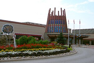
Casino Rama
Casino and hotel in Ontario, Canada
Distance: Approx. 6917 meters
Latitude and longitude: 44.64722222,-79.35027778
Casino Rama is a large casino, hotel, and entertainment complex located in the town of Rama, Ontario, on the reserve land of the Chippewas of Rama First Nation. It is jointly owned by the Chippewas of Rama First Nation and the Ontario Lottery and Gaming Corporation, with operation of the casino contracted to Gateway Casinos & Entertainment Limited. Casino Rama is Ontario's only First Nations "commercial casino" (as opposed to a lower-ranking charity casino) and the largest First Nations casino in Canada.

Orillia/Lake St John (Orillia Rama Regional) Water Aerodrome
Airport in Orillia, Ontario
Distance: Approx. 5952 meters
Latitude and longitude: 44.68333333,-79.31666667
Orillia/Lake St John (Orillia Rama Regional) Water Aerodrome (TC LID: CNV6) is located 6.5 nautical miles (12.0 km; 7.5 mi) northeast of Orillia, Ontario, Canada. The airport is classified as an airport of entry by Nav Canada and is staffed by the Canada Border Services Agency (CBSA). CBSA officers at this airport can handle general aviation aircraft only, with no more than 15 passengers.

Orillia Ramara Regional Airport
Airport in Orillia, Ontario
Distance: Approx. 6721 meters
Latitude and longitude: 44.6775,-79.30972222
Orillia Ramara Regional Airport (TC LID: CNJ4) is a registered aerodrome located 6.5 nautical miles (12.0 km; 7.5 mi) northeast of Orillia, Ontario, Canada. The airport is classified as an airport of entry by Nav Canada and is staffed by the Canada Border Services Agency (CBSA). CBSA officers at this airport can handle general aviation aircraft only, with no more than 15 passengers.

Washago station
Railway station in Ontario, Canada
Distance: Approx. 6426 meters
Latitude and longitude: 44.74877778,-79.335
Washago station is a passenger railway station in the community of Washago, Ontario, Canada, part of the Township of Severn in northeastern Simcoe County. The station is located immediately south of Simcoe County Road 169, east of Highway 11. It is the first station stop after Toronto Union Station for Via Rail's transcontinental Canadian route.

Webers
Restaurant in Ontario, Canada
Distance: Approx. 1494 meters
Latitude and longitude: 44.694,-79.39884
Webers (also known as Webers Hamburgers) is a hamburger restaurant on Ontario Highway 11, located 15 kilometres north of Orillia, Ontario that opened in July 1963. Webers grills their burgers over charcoal, with a grill man said to be able to flip up to 800 patties an hour. Long line ups are a common sight at the restaurant, which made the restaurant build a footbridge over the highway to provide access for guests from the southbound side.
Rama, Ontario
Distance: Approx. 3682 meters
Latitude and longitude: 44.702734,-79.339592
Rama is a First Nations community on the Chippewas of Rama First Nation reserve in Ontario, Canada. It is the home of Casino Rama. The community sports complex is called the Mnjikaning Arena Sports Ki, which was the home arena of the Couchiching Terriers ice hockey team, once affiliated with the Barrie Colts.
Moose Deer Point First Nation
Indian reserve in Ontario, Canada
Distance: Approx. 6826 meters
Latitude and longitude: 44.7,-79.3
Moose Deer Point First Nation is a Potawatomi First Nation in the District Municipality of Muskoka, Ontario. It has a reserve called Moose Point 79. The reserve is located along Twelve Mile Bay.
Mnjikaning First Nation 32
Indian reserve in Ontario, Canada
Distance: Approx. 6826 meters
Latitude and longitude: 44.7,-79.3
Mnjikaning First Nation 32 is an Anishinaabe reserve in Simcoe County, Ontario. It is the main reserve of the Chippewas of Rama First Nation.

Lake St. George Golf Club
Golf course in Washago, Canada
Distance: Approx. 2690 meters
Latitude and longitude: 44.72795,-79.38279
Lake St. George Golf Club is a 27-hole public golf course located in Washago, Ontario, Canada.
Washago Aerodrome
Airport in Washago, Ontario
Distance: Approx. 4506 meters
Latitude and longitude: 44.74055556,-79.36194444
Washago Aerodrome is located 1.3 nautical miles (2.4 km; 1.5 mi) west southwest of Washago, Ontario, Canada. It appears on Nav Canada navigation charts as an abandoned aerodrome, and is no longer listed in the Canada Flight Supplement. The former runway is still visible from the air.
Severn Bridge/Buck Lake Water Aerodrome
Airport in Canada
Distance: Approx. 7839 meters
Latitude and longitude: 44.77166667,-79.41305556
Severn Bridge/Buck Lake Water Aerodrome (TC LID: CBL2) is located 3.4 nautical miles (6.3 km; 3.9 mi) west of Severn Bridge, Ontario, Canada.
Weather in this IP's area
overcast clouds
-8 Celsius
-10 Celsius
-8 Celsius
-8 Celsius
1030 hPa
95 %
1030 hPa
1000 hPa
273 meters
1.35 m/s
2.34 m/s
168 degree
100 %