Country:
 USA
USARegion:
City:
Latitude and Longitude:
Time Zone:
Postal Code:
IP information under different IP Channel
ip-api
Country
Region
City
ASN
Time Zone
ISP
Blacklist
Proxy
Latitude
Longitude
Postal
Route
IPinfo
Country
Region
City
ASN
Time Zone
ISP
Blacklist
Proxy
Latitude
Longitude
Postal
Route
MaxMind
Country
Region
City
ASN
Time Zone
ISP
Blacklist
Proxy
Latitude
Longitude
Postal
Route
Luminati
Country
USASN
Time Zone
America/Chicago
ISP
AS-WAVE-1
Latitude
Longitude
Postal
db-ip
Country
Region
City
ASN
Time Zone
ISP
Blacklist
Proxy
Latitude
Longitude
Postal
Route
ipdata
Country
Region
City
ASN
Time Zone
ISP
Blacklist
Proxy
Latitude
Longitude
Postal
Route
Popular places and events near this IP address

Beaux Arts Village, Washington
Town in Washington, United States
Distance: Approx. 2363 meters
Latitude and longitude: 47.58583333,-122.20194444
Beaux Arts () is a town located in the Eastside region of King County, Washington, United States. It is the smallest municipality in the county, with a population of 317 as of the 2020 census and a land area of 0.1 sq mi. The town, a suburb of Seattle and Bellevue, is one of the most affluent areas in the metropolitan area.

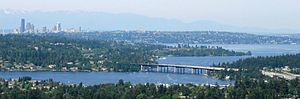
Mercer Island, Washington
City in Washington, United States
Distance: Approx. 1558 meters
Latitude and longitude: 47.57055556,-122.22194444
Mercer Island is a city in King County, Washington, United States, located on an island of the same name in the southern portion of Lake Washington. Mercer Island is in the Seattle metropolitan area, with Seattle to its west and Bellevue to its east. The island is connected to the mainland on both sides by bridges carrying Interstate 90, with the city of Seattle to the west and the city of Bellevue to the east.

Lacey V. Murrow Memorial Bridge
Floating bridge in Seattle, Washington, U.S.
Distance: Approx. 2922 meters
Latitude and longitude: 47.58988,-122.27031
The Lacey V. Murrow Memorial Bridge is a floating bridge in the Seattle metropolitan area of the U.S. state of Washington. It is one of the Interstate 90 floating bridges that carries the eastbound lanes of Interstate 90 across Lake Washington from Seattle to Mercer Island. Westbound traffic is carried by the adjacent Homer M. Hadley Memorial Bridge.

Homer M. Hadley Memorial Bridge
Floating bridge in Seattle, Washington, U.S.
Distance: Approx. 2857 meters
Latitude and longitude: 47.589841,-122.269421
The Third Lake Washington Bridge, officially the Homer M. Hadley Memorial Bridge, is a floating bridge in the Seattle metropolitan area of the U.S. state of Washington. It is one of the Interstate 90 floating bridges, carrying the westbound lanes of Interstate 90 across Lake Washington between Mercer Island and Seattle. The floating bridge is the fifth-longest of its kind in the world, at 5,811 feet (1,772 m).
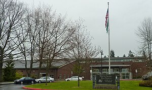
Mercer Island School District
School district in Washington, United States
Distance: Approx. 1398 meters
Latitude and longitude: 47.57166667,-122.22333333
The Mercer Island School District is a public U.S. school district in Washington. Located in an affluent bedroom community of Seattle, Mercer Island, it has a strong academic reputation. The six schools on Mercer Island provide approximately 4,000 students with primary and secondary education.
Mercer Island High School
American public high school
Distance: Approx. 1588 meters
Latitude and longitude: 47.57194444,-122.21861111
Mercer Island High School (MIHS) is a public high school located in Mercer Island, Washington, United States, as part of the Mercer Island School District. As of the 2022–23 school year, the school had an enrollment of 1,524 students and 74.51 classroom teachers (on an FTE basis), for a student–teacher ratio of 20.45. There were 68 students eligible for free lunch and 31 eligible for reduced-cost lunch.
East Channel Bridge
Highway bridge between Mercer Island and Bellevue, Washington, United States
Distance: Approx. 2509 meters
Latitude and longitude: 47.57888889,-122.2
The East Channel Bridge is a bridge carrying Interstate 90 from Mercer Island, Washington, to Bellevue, Washington, over the East Channel of Lake Washington, which separates Mercer Island from the rest of the Eastside. The original bridge was opened November 10, 1923, and was the first bridge to reach the island. George Lightfoot, known as the father of the other bridge on Mercer Island, the Lacey V. Murrow Memorial Bridge, had the charge of opening the bridge for boats.
KMIH
Radio station at Mercer Island High School in Mercer Island, Washington
Distance: Approx. 1564 meters
Latitude and longitude: 47.572,-122.219
KMIH (88.9 FM) is a high school radio station broadcasting an adult album alternative format. Licensed to Mercer Island, Washington, United States, the station is currently owned by Mercer Island School District, with studios at Mercer Island High School. This station is one of three high school radio stations in the Seattle Metro area, the other two being KNHC, and KASB. KMIH also services as the only FM service licensed to the City of Mercer Island and as such is used as one of the primary emergency communication methods for the city.

Aubrey Davis Park
Park in Mercer Island, Washington
Distance: Approx. 1355 meters
Latitude and longitude: 47.591795,-122.244465
Aubrey Davis Park, formerly the Mercer Island Lid and First Hill Lid, is a park lid covering 2,800 feet (850 m) of Interstate 90 (I-90) between West Mercer Way and 76th Avenue Southeast on Mercer Island, Washington, United States. The park was created as to minimize the impact of I-90, opening to the public in the 1990s. Former Mercer Island mayor Aubrey Davis lobbied for the park's creation in the 1970s.
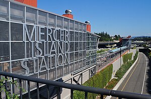
Mercer Island station
Future light rail station in Mercer Island, Washington
Distance: Approx. 630 meters
Latitude and longitude: 47.58805556,-122.23333333
Mercer Island station is a future light rail station on the 2 Line of the Link light rail network operated by Sound Transit. It will serve the city of Mercer Island and is located in the median of Interstate 90 at the north end of the island. The station is scheduled to open in 2025 as part of the 2 Line section that crosses Lake Washington between Seattle and the Eastside.
Northwest Yeshiva High School
Jewish high school in Mercer Island, Washington, United States
Distance: Approx. 2866 meters
Latitude and longitude: 47.55819722,-122.21998333
Located in Mercer Island, Washington, Northwest Yeshiva High School is the state's only accredited, co-ed, college preparatory, dual-curriculum Jewish High School.

Chace's Pancake Corral
Restaurant in Bellevue, Washington, U.S.
Distance: Approx. 3060 meters
Latitude and longitude: 47.59638889,-122.19791667
Chace's Pancake Corral is a family-owned restaurant in Bellevue, Washington, United States. Established in the 1950s, Chace's is the city's oldest restaurant.
Weather in this IP's area
light rain
11 Celsius
10 Celsius
9 Celsius
12 Celsius
1021 hPa
84 %
1021 hPa
1017 hPa
10000 meters
4.47 m/s
7.6 m/s
219 degree
100 %
07:32:44
18:14:51