Country:
Region:
City:
Latitude and Longitude:
Time Zone:
Postal Code:
IP information under different IP Channel
ip-api
Country
Region
City
ASN
Time Zone
ISP
Blacklist
Proxy
Latitude
Longitude
Postal
Route
Luminati
Country
ASN
Time Zone
America/Chicago
ISP
METROOPTIC
Latitude
Longitude
Postal
IPinfo
Country
Region
City
ASN
Time Zone
ISP
Blacklist
Proxy
Latitude
Longitude
Postal
Route
db-ip
Country
Region
City
ASN
Time Zone
ISP
Blacklist
Proxy
Latitude
Longitude
Postal
Route
ipdata
Country
Region
City
ASN
Time Zone
ISP
Blacklist
Proxy
Latitude
Longitude
Postal
Route
Popular places and events near this IP address

Green River (Duwamish River tributary)
Tributary of the Duwamish River in Washington, United States
Distance: Approx. 1953 meters
Latitude and longitude: 47.46666667,-122.25
The Green River is a 65-mile (105 km) long river in the state of Washington in the United States, arising on the western slopes of the Cascade Range south of Interstate 90. The upper Green River valley forms the western approach to Stampede Pass, and was once home to many small railroad and logging towns such as Weston, Lester, Green River Hot Springs, Nagrom, Maywood, Humphreys, Eagle Gorge, Lemolo, and Kanaskat. Shortly before World War I, the City of Tacoma, Washington, filed for water rights on the Green River.

Allentown, Tukwila, Washington
Distance: Approx. 2169 meters
Latitude and longitude: 47.49416667,-122.27611111
Allentown is a neighborhood of Tukwila, Washington, on the Duwamish River. It is situated between the Rainier View neighborhood of southern Seattle and the Boulevard Park neighborhood of unincorporated King County.
Highline Botanical Garden
Distance: Approx. 2314 meters
Latitude and longitude: 47.48,-122.30277778
Highline Botanical Garden is a 10.5-acre (4.2 ha) community botanical garden located at 13735 24th Avenue South, SeaTac, Washington. It is open daily without charge. The garden started as the private plantings by Elda and Ray Behm on a 1-acre (4,000 m2) site.

Starfire Sports
Stadium and sports facility in Tukwila, Washington, U.S.
Distance: Approx. 1940 meters
Latitude and longitude: 47.46972222,-122.24833333
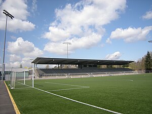
Starfire Sports is a multi-purpose stadium and sporting facility in Tukwila, Washington, United States. It is located on the banks of the Green River, just south of Seattle. The stadium is operated by the nonprofit corporation Starfire Sports and is home to several soccer and rugby teams.

Westfield Southcenter
Shopping mall in Tukwila, Washington
Distance: Approx. 2090 meters
Latitude and longitude: 47.459,-122.258
Westfield Southcenter, formerly known as Southcenter Mall, is a shopping mall located in Tukwila, Washington, United States. Owned by Unibail-Rodamco-Westfield, it is the largest shopping center in Washington state and the Pacific Northwest. The mall is anchored by Macy's (formerly The Bon Marché), JCPenney, Nordstrom, and Sears (formerly Frederick & Nelson), and also features an AMC movie theater, which opened in 2008.

Fort Dent
Distance: Approx. 2083 meters
Latitude and longitude: 47.46669444,-122.24805556
Fort Dent is a historic fort and present-day park in Tukwila, Washington.

Black River (Duwamish River tributary)
Distance: Approx. 1669 meters
Latitude and longitude: 47.47416667,-122.25083333
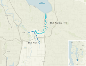
The Black River is a tributary of the Duwamish River in King County in the U.S. state of Washington. It drained Lake Washington until 1916, when the opening of the Lake Washington Ship Canal lowered the lake, causing part of the Black River to dry up. It still exists as a dammed stream about 2 miles (3.2 km) long.

Tukwila International Boulevard station
Light rail station in Tukwila, Washington
Distance: Approx. 1638 meters
Latitude and longitude: 47.46416667,-122.28805556
Tukwila International Boulevard station is a light rail station in Tukwila, Washington, United States. It is located between SeaTac/Airport and Rainier Beach stations on the 1 Line from Seattle–Tacoma International Airport to Downtown Seattle. The station consists of two elevated side platforms enclosed within a structure northeast of the interchange of State Route 99 (International Boulevard) and State Route 518.
Johnson Braund Design Group
Distance: Approx. 926 meters
Latitude and longitude: 47.46697,-122.268839
Johnson Braund, Inc. is an architecture and design firm with based out of Seattle, Washington. Firm acts as prototype designer for a number of Marriott International chains, including Residence Inn by Marriott, Courtyard by Marriott, and SpringHill Suites.

Foster, Washington
Ghost town in Washington (state)
Distance: Approx. 758 meters
Latitude and longitude: 47.48138889,-122.27555556
Foster, Washington was a former community in King County in the U.S. state of Washington. After being annexed in 1989, Foster's former area is a part of the city of Tukwila. A post office called Foster was established in 1903, and remained in operation until 1907.
Foster High School (Tukwila, Washington)
Public school in Tukwila, Washington, United States
Distance: Approx. 548 meters
Latitude and longitude: 47.475,-122.28027778
Foster High School is a public high school located in Tukwila, Washington. It serves students from 9th grade to 12th grade. It is part of the Tukwila School District, one of the most diverse school districts in the nation.

Tukwila School
Historic building in Washington, USA
Distance: Approx. 1242 meters
Latitude and longitude: 47.47222222,-122.25694444
The Tukwila School, later known as Tukwila Town Hall and Tukwila Library, is a public building in Tukwila, Washington. Built in 1920, the former school was added to the National Register of Historic Places in 1979.
Weather in this IP's area
overcast clouds
9 Celsius
8 Celsius
7 Celsius
11 Celsius
1021 hPa
82 %
1021 hPa
1012 hPa
10000 meters
3.13 m/s
4.47 m/s
117 degree
100 %
07:02:49
16:42:51
