Country:
 USA
USARegion:
City:
Latitude and Longitude:
Time Zone:
Postal Code:
IP information under different IP Channel
ip-api
Country
Region
City
ASN
Time Zone
ISP
Blacklist
Proxy
Latitude
Longitude
Postal
Route
IPinfo
Country
Region
City
ASN
Time Zone
ISP
Blacklist
Proxy
Latitude
Longitude
Postal
Route
MaxMind
Country
Region
City
ASN
Time Zone
ISP
Blacklist
Proxy
Latitude
Longitude
Postal
Route
Luminati
Country
USRegion
tx
City
houston
ASN
Time Zone
America/Chicago
ISP
CPANEL-INC
Latitude
Longitude
Postal
db-ip
Country
Region
City
ASN
Time Zone
ISP
Blacklist
Proxy
Latitude
Longitude
Postal
Route
ipdata
Country
Region
City
ASN
Time Zone
ISP
Blacklist
Proxy
Latitude
Longitude
Postal
Route
Popular places and events near this IP address
Houston Independent School District
Public school system in Texas
Distance: Approx. 3214 meters
Latitude and longitude: 29.802779,-95.454267
The Houston Independent School District (HISD) is the largest public school system in Texas, and the eighth-largest in the United States. Houston ISD serves as a community school district for most of the city of Houston and several nearby and insular municipalities in addition to some unincorporated areas. Like most districts in Texas, it is independent of the city of Houston and all other municipal and county jurisdictions.

Scarborough High School (Texas)
Public secondary school in Houston, Texas, U.S.
Distance: Approx. 85 meters
Latitude and longitude: 29.82916667,-95.46958333
George Cameron Scarborough High School is a secondary school located at 4141 Costa Rica in Houston, Texas, United States with a ZIP code of 77092. Part of the Houston Independent School District, Scarborough serves grades nine through twelve and has Houston ISD's Futures Academy.
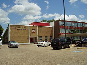
Waltrip High School
Public high school in Houston, Texas, United States
Distance: Approx. 3553 meters
Latitude and longitude: 29.819442,-95.434284
Stephen Pool Waltrip High School is a public high school located at 1900 West 34th Street in Houston, Texas, United States, 77018. Waltrip, which serves grades 9 through 12, is a part of the Houston Independent School District. Waltrip has Houston ISD's Research and Technology magnet program.

Theatre Suburbia
Distance: Approx. 2964 meters
Latitude and longitude: 29.8321,-95.5
Theatre Suburbia is a non-profit community theatre company in northwest Houston, Texas. The company is the city's longest running all-volunteer playhouse, having presented a full season of performances every year since 1961.
Northwest Mall
Shopping mall in Texas, United States
Distance: Approx. 3579 meters
Latitude and longitude: 29.7992,-95.4541
Northwest Mall was a shopping mall located in the Lazybrook/Timbergrove neighborhood of Houston, Texas near the intersection of U.S. Route 290 and Loop 610. The mall opened in October 1968, two weeks after its sister property, Almeda Mall, opened on the south side of Houston. The malls were nearly twins of each another.

Delmar Stadium
Stadium in Houston, Texas, US
Distance: Approx. 3052 meters
Latitude and longitude: 29.80361111,-95.45611111
Delmar Stadium is a 12,000-seat stadium located at 1900 Mangum Road in Houston, Texas, United States. It is primarily used for American football games of Houston Independent School District schools. It is a part of the Delmar-Tusa Sports complex includes a 5,000-seat basketball/volleyball arena, Delmar Fieldhouse, a 6,000-seat rugby/football/soccer/track venue, Dyer Stadium, a 3,000-seat football/soccer field, Delmar Jr.

Delmar Fieldhouse
Arena in Houston, Texas, U.S.
Distance: Approx. 3103 meters
Latitude and longitude: 29.80277778,-95.45694444
The James M. Delmar Fieldhouse is a 5,000-seat multi-purpose arena located in Houston, Texas. It is one of several Houston Independent School District’s athletics facilities. The $35.2 million facility hosts basketball and volleyball games and tournaments, as well as graduation ceremonies and other special events.
Southern Apache Museum
Museum in Houston, Texas, United States
Distance: Approx. 3661 meters
Latitude and longitude: 29.798565,-95.453642
The Southern Apache Museum is a nonprofit 501(c)(3) in Houston, Texas located 9600 Hempstead Highway, 550 Northwest Mall. This museum was created to educate the public about Native American history and cultures in Texas.

College of Health Care Professions
Private for-profit school in Texas, US
Distance: Approx. 3314 meters
Latitude and longitude: 29.8081,-95.4445
The College of Health Care Professions (CHCP) is a private for-profit school of allied health professions with its headquarters in Houston, Texas, and multiple campuses throughout the state.
Neon Boots Dancehall & Saloon
Bar in Houston, Texas, U.S.
Distance: Approx. 1671 meters
Latitude and longitude: 29.814445,-95.475974
Neon Boots Dancehall & Saloon is a Country and Western bar/honky tonk that was founded as the Esquire Ballroom in 1955 by Raymond Proske in Houston, Texas, at 11410 Hempstead northwest of downtown Houston. In the 1970s and 1980s the club was considered the main rival to Gilley's Club across town in Pasadena. The Esquire Ballroom closed in 1995 and remained unused for a number of years.
Houston station (Texas Central)
Planned high-speed rail terminus in the United States
Distance: Approx. 3579 meters
Latitude and longitude: 29.7992,-95.4541
Houston is the planned southern terminus of the Texas Central Railway high-speed line. The station is located in the Lazybrook/Timbergrove neighborhood of Houston, Texas, northeast of the Interstate 610 and U.S. Route 290 interchange at the site of the former Northwest Mall. The station is about 1.5 miles (2.4 km) from the METRO Northwest Transit Center and about 8 miles (13 km) from Downtown.
El Hidalguense
Mexican restaurant in Houston, Texas, U.S.
Distance: Approx. 2885 meters
Latitude and longitude: 29.8025,-95.47055556
El Hidalguense is a Mexican restaurant in Houston, Texas. Established in April 1994, the business was included in The New York Times's 2023 list of the 50 best restaurants in the United States.
Weather in this IP's area
clear sky
35 Celsius
42 Celsius
33 Celsius
36 Celsius
1009 hPa
54 %
1009 hPa
1007 hPa
10000 meters
3.6 m/s
07:08:55
19:22:08