208.69.252.161 - IP Lookup: Free IP Address Lookup, Postal Code Lookup, IP Location Lookup, IP ASN, Public IP
Country:
 Canada
Region:
City:
Location:
Time Zone:
Postal Code:
ISP:
ASN:
language:
User-Agent:
Proxy IP:
Blacklist:
IP information under different IP Channel
ip-api
Country
Region
City
ASN
Time Zone
ISP
Blacklist
Proxy
Latitude
Longitude
Postal
Route
db-ip
Country
Region
City
ASN
Time Zone
ISP
Blacklist
Proxy
Latitude
Longitude
Postal
Route
IPinfo
Country
Region
City
ASN
Time Zone
ISP
Blacklist
Proxy
Latitude
Longitude
Postal
Route
IP2Location
208.69.252.161Country
caRegion
british columbia
City
vancouver
Time Zone
America/Vancouver
ISP
Language
User-Agent
Latitude
Longitude
Postal
ipdata
Country
Region
City
ASN
Time Zone
ISP
Blacklist
Proxy
Latitude
Longitude
Postal
Route
Popular places and events near this IP address
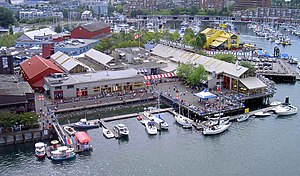
Granville Island
Peninsula and shopping district in Vancouver, British Columbia
Distance: Approx. 524 meters
Latitude and longitude: 49.27083333,-123.13416667
Granville Island is a peninsula and shopping district in the Fairview neighbourhood of Vancouver, British Columbia, Canada, across False Creek from Downtown Vancouver, under the south end of the Granville Street Bridge. Formerly an industrial manufacturing area, it was named after Granville Leveson-Gower, 2nd Earl Granville. It includes a public market, restaurants, a marina, a hotel, the False Creek Community Centre, numerous artists' studios and workshops, and various performing arts theatres, including the Arts Club Theatre Company and Carousel Theatre.
Fraser Institute
Canadian public policy think tank
Distance: Approx. 504 meters
Latitude and longitude: 49.27,-123.1453
The Fraser Institute is a libertarian-conservative Canadian public policy think tank and registered charity. It is headquartered in Vancouver, with additional offices in Calgary, Toronto, and Montreal. It has links to think tanks worldwide through the Economic Freedom Network and is a member of the free-market Atlas Network.

Burrard Bridge
Bridge in Vancouver
Distance: Approx. 369 meters
Latitude and longitude: 49.2754,-123.1366
The Burrard Street Bridge (sometimes referred to as the Burrard Bridge) is a four-lane, Art Deco style, steel truss bridge constructed in 1930–1932 in Vancouver, British Columbia, Canada. The high, five part bridge on four piers spans False Creek, connecting downtown Vancouver with Kitsilano via connections to Burrard Street (formerly Cedar Street south of False Creek) on both ends. It is one of three bridges crossing False Creek.

H. R. MacMillan Space Centre
Astronomy museum in British Columbia, Canada
Distance: Approx. 443 meters
Latitude and longitude: 49.276205,-123.1444
The H.R. MacMillan Space Centre, is an astronomy museum located at Vanier Park in Vancouver, British Columbia. The museum was opened on October 28, 1968, containing a Planetarium Star Theatre. Today the museum includes an exhibit gallery and demonstration theatre where public lectures and events are hosted.

Vancouver Fringe Festival
Theatre festival in Vancouver, Canada
Distance: Approx. 527 meters
Latitude and longitude: 49.2699,-123.1352
The Vancouver Fringe Festival is an annual alternative theatre festival held in Vancouver, British Columbia, Canada established in 1985. The event is organized and sponsored by the Vancouver Fringe Theatre Society, a non-profit organization founded in 1983 as the First Vancouver Theatrespace Society. The festival is usually staged in September at a number of venues around the city.
Museum of Vancouver
Civic museum in British Columbia, Canada
Distance: Approx. 411 meters
Latitude and longitude: 49.27611111,-123.14388889
The Museum of Vancouver (MOV) (formerly the Vancouver Museum and prior to that the Centennial Museum) is a civic history museum located in Vanier Park, Vancouver, British Columbia. The MOV is the largest civic museum in Canada and the oldest museum in Vancouver. The museum was founded in 1894 and went through a number of iterations before being rebranded as the Museum of Vancouver in 2009.

Senakw
Village site, housing development
Distance: Approx. 163 meters
Latitude and longitude: 49.2735,-123.1426
Sen̓áḵw (Salishan pronunciation: [sen̰aqʷ]) or sən̓aʔqʷ (Salishan pronunciation: [sənˀaʔqʷ]), rendered in English as Snawk, Snawq, Sneawq, or Snawkw, is a village site of the Indigenous Squamish people, located near what is now known as the Kitsilano neighbourhood of Vancouver, British Columbia, Canada. In 1869 the Colonial Government set aside land around the village, and in 1877 the Joint Reserve Commission established by the Provincial and Federal Governments to deal with land allotments to indigenous people in B.C., expanded the area set aside to approximately 80 acres (32 ha) as False Creek Indian Reserve No. 6 or more popularly the Kitsilano Indian Reserve.

Seaforth Armoury
Drill Hall / armoury in Vancouver British Columbia
Distance: Approx. 377 meters
Latitude and longitude: 49.271013,-123.144363
The Seaforth Armoury is a Canadian Forces armoury located at 1650 Burrard Street in Vancouver, British Columbia. It is the home of The Seaforth Highlanders of Canada, a Primary Reserve Infantry unit. The building was designed by the architectural firm of McCarter and Nairne, and is now listed as a Class A Heritage Building.

Armoury Studios
Canadian recording studio
Distance: Approx. 354 meters
Latitude and longitude: 49.2704,-123.1427
Armoury Studios is a Canadian recording studio located in Vancouver, British Columbia's Kitsilano neighbourhood.

Vancouver Academy of Music
Distance: Approx. 335 meters
Latitude and longitude: 49.2747,-123.1444
The Vancouver Academy of Music (VAM) is a Canadian music conservatory located in Vancouver, British Columbia. The school was founded as the Community Music School of Greater Vancouver in 1969 through efforts made by the Vancouver Community Arts Council. The school was originally located on West 12th Ave but relocated to the Music Centre in Vanier Park in May 1976.
Seaforth Peace Park
Park in British Columbia, Canada
Distance: Approx. 444 meters
Latitude and longitude: 49.2716,-123.146
Seaforth Peace Park, formerly Seaforth Park, is a park in Vancouver's Kitsilano neighbourhood, in British Columbia, Canada. The park's name refers to the neighboring Seaforth Armoury.
AnnaLena (restaurant)
Restaurant in Vancouver, British Columbia
Distance: Approx. 537 meters
Latitude and longitude: 49.27081,-123.14683
AnnaLena is a restaurant in Vancouver, British Columbia. The restaurant has received a Michelin star.
Weather in this IP's area
snow
-2 Celsius
-2 Celsius
-3 Celsius
-1 Celsius
1011 hPa
89 %
1011 hPa
998 hPa
1609 meters
0.89 m/s
2.68 m/s
99 degree
100 %