Country:
 USA
USARegion:
City:
Latitude and Longitude:
Time Zone:
Postal Code:
IP information under different IP Channel
ip-api
Country
Region
City
ASN
Time Zone
ISP
Blacklist
Proxy
Latitude
Longitude
Postal
Route
IPinfo
Country
Region
City
ASN
Time Zone
ISP
Blacklist
Proxy
Latitude
Longitude
Postal
Route
MaxMind
Country
Region
City
ASN
Time Zone
ISP
Blacklist
Proxy
Latitude
Longitude
Postal
Route
Luminati
Country
USRegion
ut
City
stgeorge
ASN
Time Zone
America/Denver
ISP
IW-ASN-11071
Latitude
Longitude
Postal
db-ip
Country
Region
City
ASN
Time Zone
ISP
Blacklist
Proxy
Latitude
Longitude
Postal
Route
ipdata
Country
Region
City
ASN
Time Zone
ISP
Blacklist
Proxy
Latitude
Longitude
Postal
Route
Popular places and events near this IP address

Utah Tech University
University in St. George, Utah, United States
Distance: Approx. 2091 meters
Latitude and longitude: 37.10447222,-113.56519444
Utah Tech University (UT), formerly Dixie State University (DSU), is a polytechnic 4-year public university in St. George, Utah. The university offers doctoral degrees, master's degrees, bachelor's degrees, associate degrees, and certifications.
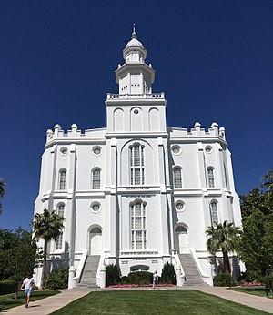
St. George Utah Temple
Latter-day Saint Temple in St. George, Utah
Distance: Approx. 2215 meters
Latitude and longitude: 37.100403,-113.578104
The St. George Utah Temple, formerly known as the St. George Temple, is a temple of the Church of Jesus Christ of Latter-day Saints in St.

KMYU
MyNetworkTV affiliate in St. George, Utah
Distance: Approx. 2774 meters
Latitude and longitude: 37.06333333,-113.57388889
KMYU (channel 12) is a television station licensed to St. George, Utah, United States, serving as the MyNetworkTV affiliate for the state of Utah. It is owned by Sinclair Broadcast Group alongside Salt Lake City–based CBS affiliate KUTV (channel 2) and independent station KJZZ-TV (channel 14).
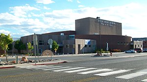
Dixie High School (Utah)
Public school in Saint George, Utah , United States
Distance: Approx. 1758 meters
Latitude and longitude: 37.09583333,-113.57638889
Dixie High School is located at 350 East 700 South, in St. George, Utah, United States. It is a Utah Class 4A school of Region 9 (2023-2025 classification) and reported 1,248 students on October 1, 2018.
Bruce Hurst Field
Distance: Approx. 1530 meters
Latitude and longitude: 37.09916667,-113.56583333
Bruce Hurst Field is a stadium in St. George, Utah. It is primarily used for baseball, hosting the Utah Tech University baseball team.
Burns Arena
Indoor arena at Utah Tech University
Distance: Approx. 1730 meters
Latitude and longitude: 37.101,-113.566
Burns Arena is a multi-purpose arena in St. George, Utah. It is the home of the Utah Tech Trailblazers basketball teams.
St. George Regional Hospital
Hospital in St. George, Utah, United States
Distance: Approx. 1688 meters
Latitude and longitude: 37.1,-113.55361111
Intermountain St. George Regional Hospital (formerly Dixie Regional Medical Center (DRMC)) is a 284-bed hospital located on two campuses in St. George, Utah, United States.
KWBR-LP
Radio station in St. George, Utah
Distance: Approx. 2745 meters
Latitude and longitude: 37.06333333,-113.57305556
KWBR (105.7 FM) is a radio station broadcasting a Smooth Jazz music format. Licensed to St. George, Utah, United States, the station is currently owned by Association of Community Resources and News (A.C.O.R.N.).
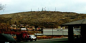
Webb Hill
Distance: Approx. 2707 meters
Latitude and longitude: 37.0635923,-113.5727338
Webb Hill is a hill located in St. George, Utah, in Washington County. The hill houses numerous radio and television tower facilities that serve the local area.
Santa Clara River (Utah)
River in Utah, United States
Distance: Approx. 2360 meters
Latitude and longitude: 37.07305556,-113.58194444
The Santa Clara River is a 52-mile-long (84 km) river whose three forks join above Pine Valley in the Pine Valley Mountains in Washington County, Utah, United States. It flows west, then south, then briefly southeast before joining the Virgin River just south of downtown St. George.
Dixie Center
Convention center in St. George, Utah, United States
Distance: Approx. 2151 meters
Latitude and longitude: 37.076918,-113.582284
The Dixie Center is a convention center located in St. George, Utah, United States. It was built in 1998, with renovations taking place in 2006.

Greater Zion Stadium
Stadium at Utah Tech University
Distance: Approx. 1598 meters
Latitude and longitude: 37.09944444,-113.56722222
Greater Zion Stadium, originally Hansen Stadium and later Trailblazer Stadium, is a stadium on the campus of Utah Tech University in St. George, Utah. It is primarily used for American football, and is the home field of the Utah Tech Trailblazers football and soccer programs.
Weather in this IP's area
clear sky
24 Celsius
23 Celsius
23 Celsius
25 Celsius
1013 hPa
23 %
1013 hPa
927 hPa
10000 meters
3.6 m/s
120 degree
07:11:17
19:52:31