Country:
 USA
USARegion:
City:
Latitude and Longitude:
Time Zone:
Postal Code:
IP information under different IP Channel
ip-api
Country
Region
City
ASN
Time Zone
ISP
Blacklist
Proxy
Latitude
Longitude
Postal
Route
IPinfo
Country
Region
City
ASN
Time Zone
ISP
Blacklist
Proxy
Latitude
Longitude
Postal
Route
MaxMind
Country
Region
City
ASN
Time Zone
ISP
Blacklist
Proxy
Latitude
Longitude
Postal
Route
Luminati
Country
USRegion
ut
City
hurricane
ASN
Time Zone
America/Denver
ISP
IW-ASN-11071
Latitude
Longitude
Postal
db-ip
Country
Region
City
ASN
Time Zone
ISP
Blacklist
Proxy
Latitude
Longitude
Postal
Route
ipdata
Country
Region
City
ASN
Time Zone
ISP
Blacklist
Proxy
Latitude
Longitude
Postal
Route
Popular places and events near this IP address

Hurricane, Utah
City in Utah, United States
Distance: Approx. 4461 meters
Latitude and longitude: 37.17416667,-113.32611111
Hurricane ( HUR-ih-kən) is a city in Washington County, Utah, United States. Its population was 20,036 as of the 2020 United States Census estimates. The Hurricane valley makes up the easternmost part of the St.
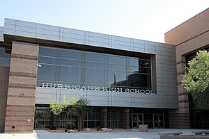
Hurricane High School (Utah)
High school in Hurricane, Utah, United States
Distance: Approx. 6741 meters
Latitude and longitude: 37.175,-113.295
Hurricane High School is the only high school in Hurricane, Utah, United States. It enrolls students in grades 10–12 from Hurricane and surrounding communities, including La Verkin, Toquerville, Hildale, Virgin, Rockville, and Springdale. As of the 2022 school year, there are 1,141 students enrolled.

Sand Hollow State Park
State park in Utah, United States
Distance: Approx. 3606 meters
Latitude and longitude: 37.11555556,-113.37638889
Sand Hollow State Park is a state park located in Utah, USA, featuring a 1,322-acre (535 ha) reservoir and an extensive off highway vehicle recreation area on Sand Mountain. The park is near the town of Hurricane. The park was officially dedicated in April 2003 and surrounds the Sand Hollow Reservoir.

Harrisburg, Utah
Ghost town in Utah, United States
Distance: Approx. 7304 meters
Latitude and longitude: 37.20583333,-113.39444444
Harrisburg is a ghost town in Washington County, Utah, United States. Established as Harrisville in 1859, the town was flooded by the Virgin River in 1862, causing the residents to move farther up Quail Creek. Soon after, the town's name was changed to Harrisburg.

Diamond Ranch Academy
Therapeutic boarding school in Utah, US
Distance: Approx. 2554 meters
Latitude and longitude: 37.1595,-113.3845
Diamond Ranch Academy was a therapeutic boarding school just outside the town of Hurricane, Utah, United States. It admitted adolescents, 12–18, with various issues, including anger management issues and major depressive disorder. Diamond Ranch Academy was founded in Idaho Falls in 1999 by Rob Dias and later moved to southern Utah, where it occupied a 200-acre (81 ha) ranch.

Quail Creek State Park
Reservoir in the state of Utah, United States
Distance: Approx. 5621 meters
Latitude and longitude: 37.1925,-113.38527778
Quail Creek State Park is a state park of Utah, United States, featuring a 600-acre (240 ha) reservoir. The park is located within Hurricane, Utah, 9 miles (14 km) west of the city center and 1.5 miles (2.4 km) south of the historic ghost town of Harrisburg. Quail Creek State Park offers camping, boating, swimming, and fishing.
Purgatory Correctional Facility
Distance: Approx. 4715 meters
Latitude and longitude: 37.15833333,-113.41222222
Purgatory Correctional Facility is the county jail of Washington County, Utah. Also known as the Washington County Jail, it is located near St. George, Utah, at Purgatory Flats, hence its unusual name.

Hurricane-LaVerkin Bridge
United States historic place
Distance: Approx. 9271 meters
Latitude and longitude: 37.18972222,-113.27277778
The Hurricane-La Verkin Bridge spans the Virgin River, connecting the towns of Hurricane and LaVerkin in southern Utah, United States.

Hurricane Canal
United States historic place
Distance: Approx. 8581 meters
Latitude and longitude: 37.18456944,-113.27797222
The Hurricane Canal is a hand-excavated irrigation canal that diverted water from the Virgin River to the east side of Hurricane, Utah, United States.

Ash Creek (Utah)
Stream in northern Washington County, Utah, U.S.
Distance: Approx. 9014 meters
Latitude and longitude: 37.203,-113.2897
Ash Creek is a stream in northern Washington County, Utah, United States. It is a tributary of the Virgin River. Ash Creek was named after the ash timber near its course.
Weather in this IP's area
clear sky
23 Celsius
22 Celsius
22 Celsius
24 Celsius
1013 hPa
33 %
1013 hPa
913 hPa
10000 meters
3.6 m/s
120 degree
07:10:26
19:51:45