Country:
 USA
USARegion:
City:
Latitude and Longitude:
Time Zone:
Postal Code:
IP information under different IP Channel
ip-api
Country
Region
City
ASN
Time Zone
ISP
Blacklist
Proxy
Latitude
Longitude
Postal
Route
IPinfo
Country
Region
City
ASN
Time Zone
ISP
Blacklist
Proxy
Latitude
Longitude
Postal
Route
MaxMind
Country
Region
City
ASN
Time Zone
ISP
Blacklist
Proxy
Latitude
Longitude
Postal
Route
Luminati
Country
USRegion
ut
City
cedarcity
ASN
Time Zone
America/Denver
ISP
IW-ASN-11071
Latitude
Longitude
Postal
db-ip
Country
Region
City
ASN
Time Zone
ISP
Blacklist
Proxy
Latitude
Longitude
Postal
Route
ipdata
Country
Region
City
ASN
Time Zone
ISP
Blacklist
Proxy
Latitude
Longitude
Postal
Route
Popular places and events near this IP address

Cedar City, Utah
City in the United States
Distance: Approx. 45 meters
Latitude and longitude: 37.6775,-113.06194444
Cedar City is the largest city in Iron County, Utah, United States. Located 250 miles (400 km) south of Salt Lake City, it is 170 miles (270 km) north of Las Vegas on Interstate 15. Southern Utah University is located in Cedar City.
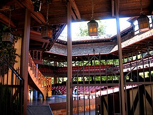
Utah Shakespeare Festival
Annual Theatrical Festival in Cedar City, Utah, United States
Distance: Approx. 535 meters
Latitude and longitude: 37.67628056,-113.06798056
The Utah Shakespeare Festival is a theatrical festival that performs works by Shakespeare as their cornerstone. The Festival is held during the summer and fall on the campus of Southern Utah University in Cedar City, Utah, United States.

Southern Utah University
Public university in Cedar City, Utah, US
Distance: Approx. 868 meters
Latitude and longitude: 37.675448,-113.071632
Southern Utah University (SUU) is a public university in Cedar City, Utah, United States. Founded in 1897 as a normal school, Southern Utah University now has over 1,800 graduates each year with baccalaureate and other graduate degrees from its six colleges. SUU offers more than 140 undergraduate and 19 graduate programs.
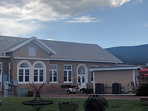
America First Event Center
Distance: Approx. 989 meters
Latitude and longitude: 37.67555556,-113.07305556
America First Event Center is a 5,300-seat multi-purpose arena in Cedar City, Utah. It was built in 1985. It is home to the Southern Utah University Thunderbirds basketball, volleyball and gymnastics teams.

Eccles Coliseum
Stadium in Utah, United States
Distance: Approx. 1324 meters
Latitude and longitude: 37.67583333,-113.07694444
Eccles Coliseum is an 8,500-seat multi-purpose stadium in the western United States, on the campus of Southern Utah University in Cedar City, Utah. It is the home venue of the Southern Utah Thunderbirds football team of the United Athletic Conference and track and field teams of the Western Athletic Conference (WAC). The stadium also hosts the Utah Summer Games opening ceremonies and several events.
SUCCESS Academy
Charter school in Utah
Distance: Approx. 939 meters
Latitude and longitude: 37.67472222,-113.07222222
SUCCESS Academy (Southern Utah Center for Computer, Engineering and Science Students) is an early college high school based in Cedar City, Utah, United States. SUCCESS Academy has three campuses, one located at Southern Utah University (SUU) in the Iron County School District, one at Utah Tech University in the Washington County School District.
Cedar City Historic District
Historic district in Utah, United States
Distance: Approx. 453 meters
Latitude and longitude: 37.67305556,-113.06138889
The Cedar City Historic District is a set of one hundred and seventy-two buildings in Cedar City, Utah. Of these, one hundred and four contribute to its historical integrity. Cedar City was originally an iron works near the Latter-day Saint city of Parowan.
Joseph S. Hunter House
Historic house in Utah, United States
Distance: Approx. 149 meters
Latitude and longitude: 37.677268,-113.060317
Joseph S. Hunter House is a historic house in Cedar City, Utah, United States. Listed on the National Register of Historic Places in 1982, it was delisted in 2007 after being moved to the Frontier Homestead State Park Museum.
Frontier Homestead State Park Museum
State park and museum in the United States
Distance: Approx. 1251 meters
Latitude and longitude: 37.68833333,-113.06166667
Frontier Homestead State Park Museum is a state park and museum of in Cedar City, Utah, United States.
Thunderbird Park (Cedar City)
Distance: Approx. 1130 meters
Latitude and longitude: 37.67666,-113.074813
Thunderbird Park was a baseball venue in Cedar City, Utah, United States. It was home to the Southern Utah Thunderbirds baseball team. As part of the athletic program's move to the Big Sky Conference for the 2012–2013 season, Southern Utah's baseball program was discontinued.
Groovefest American Music Festival
Distance: Approx. 514 meters
Latitude and longitude: 37.68166667,-113.06111111
Groovefest Music & Art Festival - formerly Groovefest American Music Festival is a multi-day music festival held in Cedar City, Utah, United States. The festival is held each year during the final week of June. It is a seven-day festival that is dedicated to American music, with genres including blues and folk, bluegrass, country, Americana, and jazz.
Cedar City Railroad Depot
Distance: Approx. 524 meters
Latitude and longitude: 37.6818,-113.0623
The Cedar City Railroad Depot was a train station in Cedar City in the U.S. state of Utah. Built in 1923, the station directly contributed to the growth of the iron ore and livestock industries in the area. The depot was constructed by the Union Pacific Railroad.
Weather in this IP's area
clear sky
16 Celsius
15 Celsius
16 Celsius
19 Celsius
1016 hPa
39 %
1016 hPa
828 hPa
10000 meters
3.6 m/s
150 degree
07:08:53
19:50:55