208.64.22.161 - IP Lookup: Free IP Address Lookup, Postal Code Lookup, IP Location Lookup, IP ASN, Public IP
Country:
Region:
City:
Location:
Time Zone:
Postal Code:
ISP:
ASN:
language:
User-Agent:
Proxy IP:
Blacklist:
IP information under different IP Channel
ip-api
Country
Region
City
ASN
Time Zone
ISP
Blacklist
Proxy
Latitude
Longitude
Postal
Route
db-ip
Country
Region
City
ASN
Time Zone
ISP
Blacklist
Proxy
Latitude
Longitude
Postal
Route
IPinfo
Country
Region
City
ASN
Time Zone
ISP
Blacklist
Proxy
Latitude
Longitude
Postal
Route
IP2Location
208.64.22.161Country
Region
connecticut
City
trumbull
Time Zone
America/New_York
ISP
Language
User-Agent
Latitude
Longitude
Postal
ipdata
Country
Region
City
ASN
Time Zone
ISP
Blacklist
Proxy
Latitude
Longitude
Postal
Route
Popular places and events near this IP address
Trumbull, Connecticut
Town in Fairfield County, Connecticut, US
Distance: Approx. 2075 meters
Latitude and longitude: 41.23305556,-73.21833333
Trumbull is a town located in Fairfield County, Connecticut, United States. The town is part of the Greater Bridgeport Planning Region, and borders on the cities of Bridgeport and Shelton, as well as the towns of Stratford, Fairfield, Easton and Monroe. The population was 36,827 during the 2020 census.
Trumbull High School
Public school in Trumbull, Fairfield County, Connecticut, United States
Distance: Approx. 2102 meters
Latitude and longitude: 41.2645,-73.1922
Trumbull High School is a large public high school located in Trumbull, Connecticut. The current principal is Todd Manuel.
Christian Heritage School (Connecticut)
School in Trumbull, Connecticut
Distance: Approx. 2368 meters
Latitude and longitude: 41.2392,-73.18439
Christian Heritage School is a private, non-denominational, college preparatory Christian school in Trumbull, Connecticut, providing education to students from kindergarten through 12th grade.
WCUM
Radio station in Connecticut, United States
Distance: Approx. 3460 meters
Latitude and longitude: 41.21954167,-73.20178056
WCUM (1450 AM) is a radio station broadcasting a Spanish tropical format. Licensed to Bridgeport, Connecticut, United States, it serves the Bridgeport area. WCUM’s transmitter and studios are both located on State Street and Chopsey Road in Bridgeport.
Trumbull Mall
Shopping mall in Trumbull, Connecticut
Distance: Approx. 2480 meters
Latitude and longitude: 41.231268,-73.224225
Trumbull Mall (formerly known as Westfield Trumbull, Westfield Shoppingtown Trumbull, and Trumbull Shopping Park) is a shopping mall located in Trumbull, Connecticut. It was the first enclosed shopping mall in Connecticut upon opening in 1964. The mall was developed by the Frogue Corporation, and was the first U.S. acquisition by Australian mall operator Westfield Group in 1977.
Pinewood Lake
Lake in Connecticut, United States
Distance: Approx. 2804 meters
Latitude and longitude: 41.256,-73.176
Pinewood Lake is a natural lake located northwest of 330 feet (100 m) tall Mischa Hill in the Nichols Farms Historic District section of Trumbull, Connecticut.
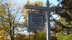
Unity Burial Ground
Cemetery in Trumbull, Connecticut
Distance: Approx. 3166 meters
Latitude and longitude: 41.2363,-73.1756
The Unity Burial Ground is a small graveyard located on the southeast end of White Plain in the Nichols section of Trumbull, Connecticut. It is located a few rods north of the site of the first meeting house that was built in the parish of Unity, off of White Plains Road. The cemetery was laid out in 1730 and the first burial was that of 7 year old Samuel Bennitt on June 21, 1731.
Long Hill, Trumbull, Connecticut
Place in Connecticut, United States
Distance: Approx. 3426 meters
Latitude and longitude: 41.2775,-73.2275
Long Hill is a neighborhood and census-designated place (CDP) in the town of Trumbull in Fairfield County, Connecticut, United States. It is located west of the Pequonnock River. The main thoroughfare is Connecticut Route 111, present-day Main Street.

St. Theresa Church (Trumbull, Connecticut)
Church in Connecticut, United States
Distance: Approx. 1629 meters
Latitude and longitude: 41.23844722,-73.22018611
St. Theresa Church is a Roman Catholic church in Trumbull, Connecticut, a part of the Diocese of Bridgeport. The parish is considered the Mother Church of Trumbull and is the largest in town with over 3,100 parishioner families.

Fairchild Wheeler Interdistrict Multi-Magnet High School
Magnet school in Bridgeport, Connecticut
Distance: Approx. 3437 meters
Latitude and longitude: 41.2251,-73.1847
Fairchild Wheeler Interdistrict Multi-Magnet High School is a magnet high school located in Bridgeport, Connecticut. It has an enrollment of approximately 1500 students in grades 9 through 12. 70% of students live in Bridgeport, and 30% of students live in the following districts: Easton, Fairfield, Milford, Monroe, Shelton, Stratford and Trumbull.
Trumbull Center, Connecticut
Census-designated place in Connecticut, United States
Distance: Approx. 1262 meters
Latitude and longitude: 41.24416667,-73.19583333
Trumbull Center is a section or neighborhood of the town of Trumbull in Fairfield County, Connecticut in New England. It is considered the center of the town, and was the seat of town government from 1883 through 1957. The Pequonnock River flows through the center in an easterly direction.
Daniels Farm, Connecticut
Census-designated place in Connecticut, United States
Distance: Approx. 3116 meters
Latitude and longitude: 41.27777778,-73.20222222
Daniels Farm is a census-designated place (CDP) in the town of Trumbull, Fairfield County, Connecticut, United States. It is in the northeastern part of Trumbull and is bordered to the northeast by the city of Shelton. The Connecticut Route 25 expressway forms the southwest edge of the CDP, and Route 111 (Monroe Turnpike) forms the short northwest edge.
Weather in this IP's area
overcast clouds
-4 Celsius
-9 Celsius
-5 Celsius
-3 Celsius
1011 hPa
81 %
1011 hPa
1001 hPa
10000 meters
4.02 m/s
7.57 m/s
231 degree
100 %


